Related Research Articles
Transport in Lithuania relies mainly on road and rail networks.

Daugavpils is a state city in southeastern Latvia, located on the banks of the Daugava River, from which the city derives its name. The parts of the city to the north of the river belong to the historical Latvian region of Latgale, and those to the south lie in Selonia. It is the second-largest city in the country after the capital Riga, which is located some 230 kilometres northwest and is the ninth most populous city in the Baltic states.
Jēkabpils district was an administrative division of Latvia, located in Latgale region, in the country's east. It was organized into three cities and twenty one parishes, each with a local government authority. The main city in the district was Jēkabpils.

Latgale, also known as Latgalia or Latgallia, is one of the Historical Latvian Lands. It is the easternmost region of the country and lies north of the Daugava River. While most of Latvia is historically Lutheran, Latgale is predominantly Roman Catholic: 65.3% according to a 2011 survey. After the Counter-Reformation it was the northernmost predominantly Catholic province or region in Europe. There is a considerable Eastern Orthodox minority (23.8%), of which 13.8% are Russian Orthodox Christians and 10.0% are Old Believers. As of 2020, the region's population was 255,968.

Selonia, also known as Augšzeme, is one of the Historical Latvian Lands encompassing the eastern part of the historical region of Semigallia as well as a portion of northeastern Lithuania. Its main city and cultural center is Jēkabpils. The Selonian language has become extinct, though some of the inhabitants still speak a Selonian subdialect.

The University of Daugavpils is a public university in Daugavpils, Latvia, and the largest regional university in the country.

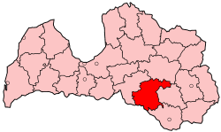
Daugavpils District was an administrative division of Latvia, located in Latgale region, in the country's south-east. It was organized into two cities and twenty one parishes, each with a local government authority. The district council headquarters were located in the city of Daugavpils, which, however, was not part of the district. As of 2009, The district's area was 2,525.5 km2, which contained 21 parishes, one city and one municipality.

The Daugavpils International Airport was located 12 km northeast of Daugavpils in the village of Lociki, Naujene Parish, Augšdaugava Municipality, in the Latgale region of Latvia.

Naujene Parish is an administrative unit of Augšdaugava Municipality in the Latgale region of Latvia.

Vidriži Parish is an administrative unit of Limbaži Municipality, Latvia.

Following the occupation of Latvia by Nazi Germany in the summer of 1941, the Daugavpils Ghetto was established in an old fortress near Daugavpils. Daugavpils is the second largest city in Latvia, located on the Daugava River in the southeastern, Latgale, region of Latvia. The city was militarily important as a major road and railway junction. Before World War II, Daugavpils was the center of a thriving Jewish community in the Latgale region and one of the most important centers of Jewish culture in eastern Europe. Over the course of the German occupation of Latvia, the vast majority of the Jews of Latgale were killed as a result of the Nazi extermination policy.

Daugavpils Fortress, also known as Dinaburg Fortress or Dvinsk Fortress, is an early 19th century fortress in Daugavpils, Latvia. It is the only early 19th century military fortification of its kind in Northern Europe that has been preserved without significant alterations. The construction of the fortress began in 1810 by decree of Tsar Alexander I of Russia, in the atmosphere of increased tension before Napoleon's invasion of the Russian Empire in 1812. Construction of the fortress, due to Napoleon's invasion, lengthy delays, serious floodings and slow construction work, was fully completed only in 1878.
Daugavpils Municipality was a municipality in Latgale, Latvia from 2009 to 2021.

Madona Municipality is a municipality in Vidzeme, Latvia. The administrative center is Madona.

Dinaburga Castle, also known as Vecdaugavpils or Vecpils, is a castle located in Naujene Parish, Augšdaugava Municipality in the Latgale region of Latvia, east of Daugavpils. It is strategically situated on a high bank of the Daugava River. It was built between 1273 and 1277 by the Livonian Order, and destroyed by Russian troops before 1577. Nowadays, fragments of the foundation are exposed.

The Saints Boris and Gleb Cathedral is the main Orthodox church in Daugavpils, Latvia. It can hold 5,000 people, being the biggest Orthodox church in Latvia.
Pilskalne Parish is an administrative unit of Augšdaugava Municipality in the Selonia region of Latvia.

Mark Rothko Art Centre is a multi-functional institution of culture, arts and education, located inside the arsenal building of the Daugavpils fortress in Daugavpils, Latvia. It is a unique in Eastern Europe, in that some original paintings of Mark Rothko are on public display, on loan from the proprietors. He was one of the greatest artists of the 20th century and was categorized by others, but not by himself, as a member of the abstract expressionism movement, specifically color-field painting, for his famous serene few color rectangle large paintings.

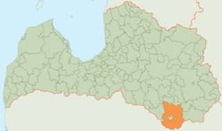
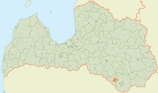
Augšdaugava Municipality is one of the 35 municipalities established in Latvia in 2021. It surrounds the independent city of Daugavpils and its municipal headquarters are located there. Its first elected municipal council has taken office on 1 July 2021.
References
- ↑ "Database of placenames" (in Latvian). Retrieved 28 September 2010.
| Authority control databases: National |
|---|
55°56′21″N26°38′52″E / 55.93917°N 26.64778°E
| | This Latgale location article is a stub. You can help Wikipedia by expanding it. |