Related Research Articles

Stevens County is a county located in the U.S. state of Washington along the Canada–US border. At the 2010 census, its population was 43,531. As of July 2020, the population was estimated to be 46,360. The county seat and largest city is Colville. The county was created in 1863 and named after Isaac Stevens, the first governor of Washington Territory.

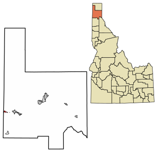
Pend Oreille County is a county located in the northeast corner of the U.S. state of Washington, along the Canada–US border. As of the 2010 census, the population was 13,001. The county seat and largest city is Newport. The county was created out of Stevens County on March 1, 1911. It is the most recently formed of the state's 39 counties. It is named after the Pend d'Oreilles tribe, who in turn were ostensibly named for large shell earrings that members wore.
Bonner County is a county in the northern part of the U.S. state of Idaho. As of the 2010 census, the population was 40,877. The county seat and largest city is Sandpoint. Partitioned from Kootenai County and established in 1907, it was named for Edwin L. Bonner, a ferry operator.
Oldtown is a city in Bonner County, Idaho and suburb of Newport, Washington, with a population of 184 at the 2010 census. It is located on the Pend Oreille River, just east of Newport. There are no natural or physical barriers, and it is strictly a political division, separated by the straight-line state boundary. Oldtown is squeezed between this boundary to the west and the river to the east, leaving the main business district on U.S. Route 2 with only 700 feet of space in which to operate on the Idaho side. Many homes are located in the south end on the other side of the railroad, as the Pend Oreille is somewhat further away here.

Cusick is a town in Pend Oreille County, Washington, United States. The population was 207 at the 2010 census. Cusick is the headquarters of the federally recognized Kalispel Indian Community of the Kalispel Reservation.

Ione is a town in Pend Oreille County, Washington, United States. The population was 447 at the 2010 census.

Metaline is a town in Pend Oreille County, Washington, United States. The population was 173 at the 2010 census.
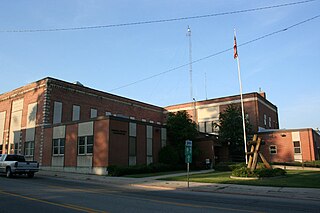
Newport is a city in and the county seat of Pend Oreille County, Washington, United States. The population was 2,126 at the 2010 census. It is part of the Spokane metropolitan area.

The Pend d'Oreille, also known as the Kalispel, are Indigenous peoples of the Northwest Plateau. Today many of them live in Montana and eastern Washington. The Kalispel peoples referred to their primary tribal range as Kaniksu.

The Little Pend Oreille National Wildlife Refuge is a wildlife preserve, one of the national wildlife refuges operated by the United States Fish and Wildlife Service. The refuge is located east of Colville, Washington, along the west slope of the Selkirk Mountain Range. It lies mostly in eastern Stevens County, with a small part extending eastward into western Pend Oreille County. It is the only mountainous, mixed-conifer forest refuge outside Alaska and the largest in Washington state.

State Route 31 (SR 31) is a Washington state highway located entirely in Pend Oreille County. The highway, which is 26.79 miles (43.11 km) long, starts at an intersection with SR 20 in Tiger and travels north to the Canada–US border north of Metaline Falls. At the border, SR 31 becomes British Columbia Highway 6 (BC 6). The route parallels the Pend Oreille River for most of its route and the primary functions of the highway is to serve and connect Tiger, Ione, Metaline and Metaline Falls with British Columbia.

Primary State Highway 6 (PSH 6) was a Washington state highway in the older primary and secondary system that existed from 1937 until 1964 in Spokane and Pend Oreille counties. The road ran from an intersection with PSH 3, U.S. Route 2 and US 395 in Spokane north to British Columbia Highway 6 (BC 6) at the Canada–US border near Metaline Falls, passing its branch route and two secondary routes.

Laclede is an unincorporated community in Bonner County, Idaho, United States. Laclede is located on U.S. Route 2 at the intersection of Riley Creek and the Pend Oreille River. Laclede has a post office with ZIP code 83841.
Blueslide is an unincorporated community in Pend Oreille County, in the U.S. state of Washington.
Dalkena is an unincorporated community in Pend Oreille County, in the U.S. state of Washington.
Davis Creek is a stream in the U.S. state of Washington. It is a tributary of Pend Oreille River.
Jared is an unincorporated community in Pend Oreille County, in the U.S. state of Washington.
Penrith is an unincorporated community in Pend Oreille County, in the U.S. state of Washington.
Garfield is an unincorporated community in Bonner County, in the U.S. state of Idaho. The community is situated on Garfield Bay, an inlet of Lake Pend Oreille.
References
- ↑ U.S. Geological Survey Geographic Names Information System: Locke, Washington
- ↑ "Pend Oreille County". Jim Forte Postal History. Retrieved 23 May 2015.
- ↑ "Historical Facts of Region Outlined at History Confab". Spokane Daily Chronicle. Aug 26, 1952. p. 5. Retrieved 23 May 2015.
Municipalities and communities of Pend Oreille County, Washington, United States | ||
|---|---|---|
| City |  | |
| Towns | ||
| Unincorporated communities | ||
Coordinates: 48°25′36″N117°19′04″W / 48.42667°N 117.31778°W
| | This Pend Oreille County, Washington state location article is a stub. You can help Wikipedia by expanding it. |