Vågan is a municipality in Nordland county, Norway. It is part of the traditional district of Lofoten. The administrative centre of the municipality is the town of Svolvær. Some of the villages in Vågan include Digermulen, Gimsøysand, Gravermarka, Henningsvær, Hopen, Kabelvåg, Kleppstad, Laupstad, Liland, Skrova, Straumnes, and Sydalen.
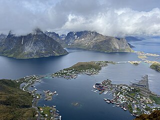
Lofoten, Lufoahtta (Lule Sami), or Lufuohttá (Northern Sami) is an archipelago and a traditional district in the county of Nordland, Norway. Lofoten has distinctive scenery with dramatic mountains and peaks, open sea and sheltered bays, beaches, and untouched lands. There are two towns, Svolvær and Leknes – the latter is approximately 169 km (105 mi) north of the Arctic Circle and approximately 2,420 km (1,500 mi) away from the North Pole. The archipelago experiences one of the world's largest elevated temperature anomalies relative to its high latitude.

Hinnøya (Norwegian) or Iinnasuolu (Northern Sami) is the fourth-largest island in Norway, and the largest outside the Svalbard archipelago. The 2,204.7-square-kilometre (851.2 sq mi) lies just off the western coast of Northern Norway. The island sits on the border of Nordland and Troms counties. The western part of the island is in the district of Vesterålen, the southwestern part is in the Lofoten district, the southeastern part is in the Ofoten district, and the northeastern part is in Troms. As of 2017, Hinnøya had a population of 32,688. The only town on the island is the town of Harstad. Some of the larger villages include Borkenes, Lødingen, Sigerfjord, and Sørvik. The island is split between several municipalities: Harstad, Tjeldsund and Kvæfjord in Troms county, as well as Andøy, Hadsel, Lødingen, Sortland, and Vågan in Nordland county.

Vesterålen or Viestterálas (Northern Sami) is a district and archipelago in Nordland county, Norway. It is located just north of Lofoten and west of Harstad. It is the northernmost part of Nordland county. Sortland is the largest town, situated near the center of the archipelago. Vesterålen includes the municipalities of Andøy, Bø, Hadsel, Sortland, and Øksnes.

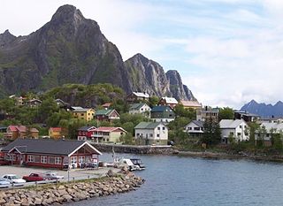
Svolvær, Suolvearra (Northern Sami), or Spålavuolle (Lule Sami) is a town and the administrative centre of Vågan Municipality in Nordland County, Norway. It is located on the island of Austvågøya in the Lofoten archipelago, along the Vestfjorden. The 2.36-square-kilometre (580-acre) town has a population (2023) of 4,736 and a population density of 2,007 inhabitants per square kilometre (5,200/sq mi).
Skutvika or Skutvik is a small village in Hamarøy Municipality in Nordland county, Norway. The village is situated at the southwestern extreme of the Hamarøya peninsula, about 90 kilometres (56 mi) north of the town of Bodø, 95 kilometres (59 mi) southwest of the town of Narvik, and 40 kilometres (25 mi) south of the town of Svolvær. To the west and south of Skutvik is the Økssundet, a sound connecting the Sagfjorden and Vestfjorden. The landscape in the immediate vicinity of the village is dominated by hills, while further north a row of mountains rises up to 950 metres (3,120 ft) above sea level.

Tjeldsundet (Norwegian) or Dielddanuorri (Northern Sami) is a strait in Northern Norway. The 50-kilometre long strait is located between the island of Hinnøya and mainland Norway in its northern part and between Hinnøya and the island of Tjeldøya in its southern part. Tjeldsundet has been an important waterway for more than 1,000 years and was well known and used during the Viking Age.
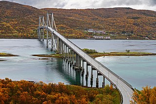
The Tjeldsund Bridge is a suspension road bridge that crosses the Tjeldsundet strait between the mainland and the island of Hinnøya in Troms county, Norway. The bridge is 1,007 metres (3,304 ft) long, the main span is 290 metres (950 ft), and the maximum clearance to the sea is 41 metres (135 ft). The bridge has 32 spans.

The Raftsund Bridge is a two-lane cantilever road bridge in Hadsel Municipality in Nordland county, Norway. The bridge carries the European route E10 highway and it crosses the Raftsundet strait between the islands of Austvågøya and Hinnøya. The bridge is 711 metres (2,333 ft) long, the main span is 298 metres (978 ft), and the maximum clearance to the sea beneath the bridge is 45 metres (148 ft). The bridge has 4 spans.

Harstad/Narvik Airport is an international airport located in Evenes Municipality in Nordland county, Norway. The airport serves the towns of Harstad and Narvik. It is co-located with Evenes Air Station of the Royal Norwegian Air Force. The civilian sector is owned and operated by the state-owned Avinor and handled 654,977 passengers in 2013. Evenes has a 2,812-meter (9,226 ft) runway, a parallel taxiway and a terminal with five gates. The airlines with daily scheduled services are Norwegian Air Shuttle, Scandinavian Airlines (SAS) and Widerøe. Destinations with daily services are Oslo, Trondheim, Bodø, Tromsø and Andenes. Evenes is the only primary airport in Central Hålogaland and its catchment area for Oslo-bound flights includes Lofoten and Vesterålen.

European route E10 is the second shortest Class A road which is part of the International E-road network. It begins in Å, Norway and ends in Luleå, Sweden. The road is about 850 kilometres (530 mi) in length. The Norwegian part of the road is also named Kong Olav Vs vei.

Narvik Airport, Framnes is a former public regional airport closed down in 2017 in Narvik Municipality in Nordland county, Norway. It was located at Framnes in the town of Narvik, along the Ofotfjorden. It was operated by the state-owned Avinor and consisted of a 965-meter (3,166 ft) runway aligned 01–19.

Leknes Airport is a regional airport serving the town of Leknes and the surrounding areas in the Lofoten archipelago in Nordland county, Norway. The airport is located just outside Leknes in Vestvågøy Municipality. The European route E10 highway passes along the east side of the airport. In 2014, Leknes Airport had 101,757 passengers. It is operated by Avinor.
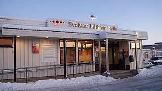
Svolvær Airport is a regional airport serving the town of Svolvær in Vågan Municipality in Nordland county, Norway.

Austvågøya is the northeasternmost and largest of the larger islands in the Lofoten archipelago in Nordland county, Norway. It is located between the Vestfjorden and the Norwegian Sea. The island of Vestvågøya lies to the southwest and the large island of Hinnøya to the northeast. In 2017, the island had about 9,000 residents.

Flakstadøya is an island in the Lofoten archipelago in Nordland county, Norway. The entire island lies within Flakstad Municipality with the Vestfjorden on the east side of the island and the Norwegian Sea on the west side of the island.
A fixed link or fixed crossing is a permanent, unbroken road or rail connection across water that uses some combination of bridges, tunnels, and causeways and does not involve intermittent connections such as drawbridges or ferries. A bridge–tunnel combination is commonly used for major fixed links.

Grytøya (Norwegian) or Rivttek (Northern Sami) is an island in Harstad Municipality in Troms county, Norway. The 108-square-kilometre (42 sq mi) island lies just north of the large island of Hinnøya and south of the island of Bjarkøya. It is surrounded by the Vågsfjorden in the east and the Andfjorden in the west. The highest peak on the island is the 1,012-metre (3,320 ft) tall mountain Nona. The population of Grytøya (2017) is 433. The southeastern part of the island is the most agriculturally productive.

County Road 82 is a road in Nordland county, Norway. It runs between the village of Fiskebøl and the town of Andenes. The road runs through the municipalities of Hadsel, Sortland, and Andøy. At Fiskebøl, the road intersects with the European route E10 highway before crossing the Hadselfjorden on the Fiskebøl–Melbu Ferry. Bridges on the road include Andøy Bridge, Sortland Bridge, Hadsel Bridge, and Børøy Bridge. Two sections are designated as part of two National Tourist Routes in Norway: the section from the intersection with E10 to Fiskebøl is part of Lofoten National Tourist Route, and the section through Andenes is part of Andenes National Tourist Route. During summer, the Andenes–Gryllefjord Ferry connects to County Road 86 at Gryllefjord on the island of Senja. Before 1 January 2010, the road was called National Road 82, but due to reforms that went into effect on that day, the county took over the ownership and maintenance of the road.

Central Hålogaland is a district of Northern Norway constituting the traditional districts of Ofoten, Lofoten, Vesterålen, and southern Troms. It has a population of 117,000, with the largest towns being Harstad (23,000) and Narvik (18,000). Smaller towns which act as regional centers include Svolvær, Sortland, and Leknes. The district covers 23 municipalities and an area of 11,600 square kilometers (4,500 sq mi). The Norwegian Police Service has Central Hålogaland as a police district with head office in Harstad.
