Lohna is a village situated in Jhanjharpur Block of Madhubani District in the Indian state of Bihar. It is well connected by road and railways. The nearest railway station is Lohna Road Station which is at distance of around 2 km from the village. Total area of the village is 2200 Bigha (About 880 Lac sq Feet). The river Lakshmana (Lakhandey) divides the village in two equal parts. The name Lohna came from Lohini Bhagwati which was on the bank of the river Lakshmana.
Jhanjharpur is a town and headquarters of a sub-division in the Madhubani district of the state of Bihar, India.
Madhubani district is one of the thirty-eight districts of Bihar state, India, and Madhubani town is the administrative headquarters of this district. Madhubani district is a part of Darbhanga division. The district occupies an area of 3,501 square kilometres (1,352 sq mi) and has a population of 4,487,379.
India, also known as the Republic of India, is a country in South Asia. It is the seventh largest country by area and with more than 1.3 billion people, it is the second most populous country as well as the most populous democracy in the world. Bounded by the Indian Ocean on the south, the Arabian Sea on the southwest, and the Bay of Bengal on the southeast, it shares land borders with Pakistan to the west; China, Nepal, and Bhutan to the northeast; and Bangladesh and Myanmar to the east. In the Indian Ocean, India is in the vicinity of Sri Lanka and the Maldives, while its Andaman and Nicobar Islands share a maritime border with Thailand and Indonesia.
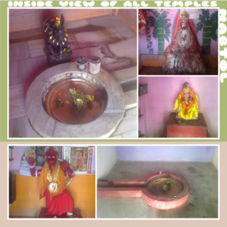
A description about the village is given in "SKAND PURAN". A Sanskrit Mahavidyalay (College) is also in the village, which is about to take its last breath. 60/70 years before it was a popular Sanskrit Mahavidyalay, 400 to 500 students were studying there. The diminished building is yet evidencing it. A temple named BIDESHWAR ASTHAN is also here. Here temple of Shiv and Parwati are situated. Gramay Devata named Maksudan Baba is near Bideshwar Asthan. People come here to Worship after Mundan and Upanayana of their sons.
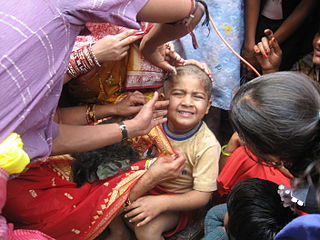
The Chudakarana or the Mundana, is the eighth of the sixteen Hindu saṃskāras (sacraments), in which a child receives their first haircut.
Upanayana is one of the traditional saṃskāras that marked the acceptance of a student by a guru (teacher) and an individual's entrance to a school in Hinduism. The tradition is widely discussed in ancient Sanskrit texts of India and varies regionally. The sacred thread is received by the boy during this ceremony, that he continues wearing across his chest thereafter.
Now the village is well connected by NH HIGHWAY 57 which was completed in 2010. Nearest Railway Station is Lohna Road Station.
Legendary poet Mahakavi Umapati (author of Rukmini Swember) was born in Lohna. [1]
Postal Pin Code for Lohna(West) and Lohna(East) are 847424 & 847407 respectively. [2]
Brahmagiri, is a mountain range in the Western Ghats of south India. It is situated on the border between Kodagu district in Karnataka state in the north and Wayanad district of Kerala state on the south. Brahmagiri Hill, at 1608 m height, is a scenic tourist attraction. The top of Brahmagiri Hill is well forested and has a lot of wildlife.
Sheikhpura is a city and a municipality in Sheikhpura district in the Indian state of Bihar. Sheikhpura is also an administrative headquarter of Sheikhpura district.
Bhabua is a city of Kaimur district in the state of Bihar, India. It is the headquarters of Kaimur district. It is all set to be declared as the world's first green City.
Kaimur district is one of the thirty-eight districts of Bihar state, India. The district headquarters are located at Bhabua. Before 1991, it was part of Rohtas District, Bihar.
Azhikode is a coastal village situated in Kannur district of Kerala, south India. The northern end of the village is called Azhikkal. The place is the birthplace of Sukumar Azhikode, an influential thinker and literary critic. It is about 5 km from Kannur.
Jhinjhak is a town and a Nagar Palika Parishad in Kanpur Dehat District in the Indian state of Uttar Pradesh. The town is situated on the banks of the Lower Ram Ganga canal.
Khadda is a town, a Nagar panchayat and a Tehsil in Kushinagar district in the Indian state of Uttar Pradesh. It is situated approximately 8km from the border of Bihar and 18km from the India-Nepal border.
Rosera is a town (Subdivision) at the bank of River Budhi Gandak. It is a municipality in Samastipur district in the Indian state of Bihar.
Mohania is a city in Kaimur district in the Indian state of Bihar. It serves as headquarters for the Mohania sub-division in Kaimur district. It is 17 km by road north of the city of Bhabua, at the intersection of National Highway 19 and State Highway 14. National Highway 319 originates from Mohania.
Obra is a small town 15 km away from the district headquarters on NH-98 (Garwa-Patna). Obra is also the headquarters of Obra block, under Daudnagar sub-division and a block of 144 villages having population of 220,000. In Obra block there are 20 panchayats each averaging 6 villages. Block stretched in north, east and south and demarcated by Daudnagar, Rafiganj, Aurangabad blocks and in west it is Rohtas district. Mahatma Gandhi and Bihar Vibhuti Dr. Anugraha Narain Sinha came to Obra during national independence movement.
Raghopur is a community development block in Vaishali district of Bihar. Situated between two streams of the Ganges river, it is a river island. It is connected to Patna by Pipa pul.
Runni Saidpur is a town and a block located in Sitamarhi district, Bihar, India. It is situated on the southern bank of the Lakhandei River. National Highway 77, the main national highway connecting Sonbarsa-Muzaffarpur-Hajipur-Patna-Gaya-Chandwa, National Highway 77 passes through Runni Saidpur. Thus it is a gateway to Sitamarhi and parts of Nepal.
Tatuar is a village under Manigachi block in Darbhanga District of Bihar. It is surrounded by villages like Barka Gaon to the east, Bhrahmpura to the west, Sakhwar to the north and Baghant to the south. Situated in the Mithila region, residents of the village speak Maithili. Among other languages, Hindi is widely understood whereas a working knowledge of English is restricted to the educated population of the village.
Aami Mandir considered as shakti peeth is a temple of Goddess Sati situated in Dighwara, India.
Nabtol is a village in northern Bihar, India. It is situated in the Jhanjharpur Block of the Madhubani District in the Indian State of Bihar. The village is near State Highway 52, and is only 3 kilometers from National Highway 57. Its PIN code is 847404.
Bakulari (Hindi:बकुलारी) is a village located in Sohagara Panchayat of Guthani Block of Siwan district in the Indian state of Bihar.
Matiya is a village of Vaishali district in the Bihar state of India.It is surrounded by four district of Bihar, which are Samastipur in East, Saran in West, Muzaffarpur in North and Patna in South. The nearest city Hajipur is about 23 km and 31 km away from here. Nearest Railway Station from here is Desari in West and Sahadai Buzurg in East.
Pilode is a village is located in Amalner Tehsil of Jalgaon district in Maharashtra, India. It is situated 10 km away from sub-district headquarter Amalner and 65 km away from district headquarter Jalgaon.
Dumari is a village in Taraiya Block of Saran district in Bihar, India. Located in a rural area of Saran district, it is one of the 79 villages of Taraiya Block. The village has 321 homes.
Moozhikkulam is a small village in Chengamanad Panchayath near Angamaly in Eranakulam district in the Indian state of Kerala. This village is situated at the banks of Chalakkudy river. Parakadavu Village office located at Moozhikulam.
This article related to a location in Bihar is a stub. You can help Wikipedia by expanding it. |