
Bhutan is a sovereign country at the crossroads of East Asia and South Asia, located towards the eastern extreme of the Himalayas mountain range. It is fairly evenly sandwiched between the sovereign territory of two nations: first, the People's Republic of China (PRC) on the north and northwest. There are approximately 477 kilometres (296 mi) of border with the country's Tibet Autonomous Region (TAR), or simply Tibet. The second nation is the Republic of India on the south, southwest, and east; there are approximately 659 kilometres (409 mi) with the states of Arunachal Pradesh, Assam, West Bengal, and Sikkim, in clockwise order from the kingdom. Bhutan's total borders amount to approximately 1,139 kilometres (708 mi). The Indian state of Sikkim to the west, the India to the south, and the Assam state of India to the southeast are other close neighbours; the former two are separated by only very small stretches of Indian territory.

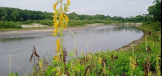
The Brahmaputra is a trans-boundary river which flows through Tibet (China), Northeastern India, and Bangladesh. It is known as Brahmaputra or Luit in Assamese, Yarlung Tsangpo in Tibetan, the Siang/Dihang River in Arunachali, and Jamuna River in Bengali. It is the 9th largest river in the world by discharge, and the 15th longest.

The Dooars or Duars are the alluvial floodplains in eastern-northeastern India and southern Bhutan that lie south of the outer foothills of the Himalayas and north of the Brahmaputra River basin. This region is about 30 km (19 mi) wide and stretches over about 350 km (220 mi) from the Teesta River in West Bengal to the Dhansiri River in Udalguri district of Assam. The region forms the gateway to Bhutan. It is part of the Terai-Duar savanna and grasslands ecoregion.

Mo Chhu is a major river in Bhutan. The word "Chhu" means "river" or "water" in Dzongkha, the official national language in Bhutan. The river rises in Gasa Dzongkhag (district) near the border between Bhutan and Tibet. From there, the Mo Chhu flows generally southward to Punakha in central Bhutan, where it joins the Pho Chhu from the northeast. The confluence of the two streams is immediately below the Punakha Dzong, which is the winter home of the Dratshang Lhentshog and the Je Khenpo. The combined streams are then joined by the Dang Chhu near the town of Wangdue Phodrang, and the name of the river becomes the Puna Tsang Chhu. The river then flows through Dagana and Tsirang Districts. After leaving Bhutan near the town of Lhamoidzingkha, formerly known as Kalikhola, the river enters Assam in India and is known as the Sankosh. The Sankosh ultimately empties into the Brahmaputra, flowing into the Bay of Bengal.

Sankosh is a river that rises in northern Bhutan and empties into the Brahmaputra in the state of Assam in India. In Bhutan, it is known as the Puna Tsang Chu below the confluences of several tributaries near the town of Wangdue Phodrang.
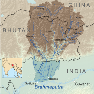
Mangde Chhu or Tongsa river flows in central Bhutan traversing roughly north–south. The river rises in Wangdue Phodrang district, near Gangkhar Puensum, Bhutan's highest peak at 7,546 metres (24,757 ft). Bhutan's main east–west highway crosses the Mangde Chhu about 8 kilometres (5 mi) west of Trongsa. South of Trongsa, the river drains the eastern slopes of the Black Mountains (Bhutan), and forms the eastern boundaries of Black Mountain National Park and Royal Manas National Park. Another highway follows the river south from Trongsa to Shemgang. The highway leaves the river at Tingtinbi, and eventually reaches the Indian border at Gelegphug. South of Tingtinbi, the Mangde is joined by the Bumthang River from the east, and is known as the Tongasa. Shortly before entering India in Assam, the Manas River flows into the river from the east, and the river exits Bhutan near Manas.

The Jaldhaka River (Pron:/ˌdʒælˈdɑːkə/), also known as Dichu, is a tributary of the Brahmaputra and a trans-boundary river flowing through India, Bhutan and Bangladesh with a length of 233 kilometres. It originates from the Bitang Lake at Kupup, Gangtok District, Sikkim, near the Jelep La pass below Dongkya Mountain Range. It flows through Pakyong District of Sikkim, India and then passes through forests of Samtse District of Bhutan where it flows for around 40 kilometres and than re-enters India at Bindu, Kalimpong district. Further it passes through Neora Valley National Park, Chapramari Wildlife Sanctuary and Gorumara National Park in West Bengal along with cities and towns, like Paren, Gairibas, Jhalong, Dhupguri, Falakata, Mathabhanga and flows through Kalimpong, Jalpaiguri and Cooch Behar districts in West Bengal, India before entering Bangladesh at Mogolhat, Lalmonirhat District of Rangpur Division. It is known as Dharla River in Bangladesh and flows through towns like Kolaghat, Phulbari and Kurigram City and Passes southwards until the Dharla debouches into the Brahmaputra River at Bagua Anantpur of Kurigram District. Due to the river's wandering over several international borders, only a small length of the river lies in Bangladesh and Bhutan and most of its path lies in India. In some places, this river is also known as Mansai river and Singhimari river.
Gaurang is a 98-kilometre (61 mi)-long river which originates in Bhutan and flows southward into India. It first enters India in Chirang district, where it is known as Swrmanga, then flows westward into Kokrajhar district, then turns south into Dhubri district, where it terminates on the right bank of the Brahmaputra River.
Chirang District is an administrative district in the Bodoland Territorial Region of Assam state in the North-East of India.

Manas National Park is a national park, Project Tiger reserve, and an elephant reserve in Assam, India. Located in the Himalayan foothills, it borders the Royal Manas National Park in Bhutan. The park is known for its rare and endangered endemic wildlife such as the Assam roofed turtle, hispid hare, golden langur and pygmy hog. Manas is also famous for its population of the wild water buffalo. Because of its exceptional biodiversity, scenery, and variety of habitats, Manas National Park is a biosphere reserve and a UNESCO World Heritage Site.

The Manas River, known in Bhutan as the Drangme Chhu, is a transboundary river in the Himalayan foothills between southern Bhutan, India, and China. It is the largest of Bhutan's four major river systems, with the other three being the Amo Chu or Torsa River, the Wang Chu or Raidak, and the Puna Tshang Chu or Sankosh. It is met by three other major streams before it again debouches into India in western Assam. The river flows for a total length of 400 kilometres (250 mi), including through Tibet for 24 km (15 mi), Bhutan for 272 kilometres (169 mi), and Assam for 104 kilometres (65 mi) before it joins the mighty Brahmaputra River at Jogighopa. A major tributary of the Manas, the Aie River, joins it in Assam at Bangpari.

The Subansiri is a trans-Himalayan river and a tributary of the Brahmaputra River that flows through Tibet's Lhuntse County in the Shannan Prefecture, and the Indian states of Arunachal Pradesh and Assam. The Subansiri is approximately 518 kilometres (322 mi) long, with a drainage basin 32,640 square kilometres (12,600 sq mi). It is the largest tributary of the Brahmaputra contributing 7.92% of the Brahmaputra's total flow.
Beki River is one of the right bank tributaries of the mighty Brahmaputra River, which flows down from the Bhutan region but a large portion flows in Indian state Assam. It touches flows from Bhutan touching Mathanguri, Naranguri, Khusrabari, Valaguri, Mainamata, Udalguri, Barpeta Road, Nichukha, Sorbhog, Kalgachia, Balaipathar, Kharballi, Bardanga, Kamarpara, Srirampur, Daoukmari, Jania, Chanpur, Rubi,Sawpur, Gobindapur, Moinbari and Balikuri. There are views of the river and its surroundings from the bridges situated on NH no- 31.
The Puthimari River rises in Assam, India. It is a tributary of the Brahmaputra River, the fourth largest in the world. The Puthimari is known for its floods and high sediment load. Puthimari River flows through Rangia Sub-division, Hajo and Hajo Sub-division. The Baralia River, Suklai River, and Lokhaitora River is a tributery river of the Puthimari river.
Pho Chhu is one of the major rivers of Bhutan, which tracks its source to Gasa District on the borders between Bhutan and Tibet. It joins with the Mo Chhu at the confluence below Punakha Dzong, the winter residence of Dratshang Lhentshog. Upon Dang Chhu joining below Wangdue Dzong, the trio flows as Puna Tsang Chhu and finally empties into the Brahmaputra, upon being joined by several tributaries on its course through the valley of Assam. Its source is susceptible to glaciers which even destroyed a part of Punakha Dzong.

Tawang Chu is the main river of the Tawang district in Arunachal Pradesh, India. The entire district may be regarded as the basin of the Tawang Chu river. In addition, two south-flowing rivers from Tibet, viz., Tsona Chu and Nyamjang Chu, join the river within the district. The combined river flows west into Bhutan, where it progresses to the Manas River and flows into the Assam state of India.

The Pagladiya River is a northern bank tributary of the Brahmaputra River in the Indian state of Assam. The Pagladiya River originates in the Bhutan hills and flows through Baksa District and Nalbari district before its confluence with the Brahmaputra River. Pagladiya River is perennial, very shallow, and is characteristically known for flash floods and high discharge rates.

The Aie River is a tributary of the Manas River in the Indian state of Assam. The river originates from Black Mountains (Bhutan). The Aie river flows through the Chirang district of Assam and joins Manas river at Bangpari of Chirang district. Aie means mother in Bodo language. The Dwijing Festival is an annual festival set on the banks of Aie river near the Hagrama bridge of Chirang district which is a colorful celebration of Assam's culture.

The Champabati River is a tributary of the Brahmaputra River in the Indian state of Assam. The Champabati River has three sub tributaries - Bhur River, Lopani and Dhol pani which are originated from Bhutan hills.

The Tipkai River is a north and Himalayan tributary of the Brahmaputra River in the Indian state of Assam. It rises in the Bhutan hills, flows through the Kokrajhar district and Dhubri district of Assam and joins the Brahmaputra River at Chatakurachar of Dhubri district.

