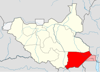
Eastern Equatoria is a state in South Sudan. It has an area of 73,472 km2. The capital City is Torit. On October 1, 1972, the state was divided into Imatong and Namorunyang states and was re-established by a peace agreement signed on 22 February 2020.

Torit is a city of Eastern Equatoria State in South Sudan.
The Ketebo people are an ethnic group in South Sudan. The Ketebo are inhabitants of Bira which is the land of the Ketebo. Bira which was a Ugandan Protectorate until 1925 and was transferred to Sudan's administration in 1926. The Ketebo are sometimes referred to by the Didinga as "Loceha/Loceka". The Ketebo live in Bira, which is one of the Payams of Kidepo County, Torit, Eastern Equatoria State of South Sudan. They are one of the smallest and least known tribes in South Sudan. The Ketebo in Uganda are called Mening, which is also one of the smallest tribes in Uganda. The population of this ethnic group is over 45,000. Bira is the land of the Ketebo which include; Lofus, Madial, Lorum, Lotome, Lojilingare, Arata, Nakoringole, Lonyili, Kamulach, Tulel, Ofi, Natedo, Nahitahapel (Ihapelmoru), Naurkori, Lochorangichokio, Lokudul, Napeyase, Ogeng, Tongoborei, Kalabe (Apoka), Irobi, Narus, Koryang, Tomoodo, Koryang, Losigiria, Irobi just to mention a few. The Ketebo people are also found in Lotukei in Budi County.

Magwi County, also Magwe County, is a county in Eastern Equatoria, South Sudan.

The Roman Catholic Diocese of Torit is a diocese located in Torit in the ecclesiastical province of Juba in South Sudan.
Torit Airport is an airport serving the town of Torit, in South Sudan.
Torit County is an administrative region in Eastern Equatoria of South Sudan, with headquarters in the town of Torit, which is also the state capital.
Tirangore is a village in the Hiyala Payam of Torit County in the Eastern Equatoria State of South Sudan. It lies to the northeast of Torit.
Chukudum is a Town in the Budi County of the Eastern Equatoria state of South Sudan.
Budi County is an administrative area of Eastern Equatoria state in South Sudan, with headquarters in Chukudum.
The Southern Sudan Peace Commission (SSPC) was established in 2006. The purpose of the Peace Commission is promote peace among the people of South Sudan and to help consolidate the results of the Comprehensive Peace Agreement (CPA) signed in January 2005 between the Sudan People's Liberation Movement (SPLM) and the Government of Sudan.
Louis Lobong Lojore is a South Sudanese Politician and a military governor in the rank of brigadier general in the South Sudan People's Defence Forces (SSPDF) and the current governor of Eastern Equatoria State in South Sudan. He was the governor of Eastern Equatoria state from 2010 to 2015, governor of Kapoeta State from 2015 to 2020, and has been the governor of the recreated Eastern Equatoria state since 29 June 2020. Lobong is the longest serving governor in South Sudan.

Namorunyang is a village and Payam of Kapoeta South County in Eastern Equatoria, South Sudan.
Kapoeta South County is an administrative region in Eastern Equatoria State. The county logo is a ram with horns and slightly bent tail. The county includes the Kapoeta Town, Machi and Namorunyang Payams.
Narus is a community in the Eastern Equatoria State of South Sudan. It is the headquarters of Kapoeta East County.
The Loyuro River is a stream in Eastern Equatoria State of South Sudan. The river originates in the east of Didinga Hills, flowing eastward into Greater Kapoeta and discharging into the swampy area northeast of Narus. The river floods during the rainy season, but ceases to flow at other times. The Toposa people have a ritual center at Loyuro River. Lolimi is a permanent water hole on the river, on the road between Narus and Kapoeta.
Kapoeta East County is an administrative region of Eastern Equatoria state in South Sudan, bordered by Kenya to the south, Ethiopia to the east and Jonglei state to the west. It is part of the Greater Kapoeta region of the state. The largest ethnic group is the Toposa people. The principal town is Narus. The county includes the disputed Ilemi triangle, controlled by Kenya. The emblem of the county is a horned bull, with big humps and a large tail.
Loyoro is a community in Eastern Equatoria state of South Sudan, about 50 kilometres (31 mi) as the crow flies to the north east of Narus. It lies on the Loyoro River. Loyoro is part of the Narus parish of the Catholic Diocese of Torit.
Nanyangacor is a community in Eastern Equatoria state of South Sudan. It is in the Eastern Uplands of Kapoeta East County, near the border with Ethiopia.
Kapoeta North County is an administrative division of Eastern Equatoria. The principal settlement is Riwoto and the largest ethnic group are the Toposa people. The county emblem is an elephant.
