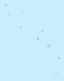
Tuvalu is an island country in the Polynesian subregion of Oceania in the Pacific Ocean. Its islands are situated about midway between Hawaii and Australia. They lie east-northeast of the Santa Cruz Islands, northeast of Vanuatu, southeast of Nauru, south of Kiribati, west of Tokelau, northwest of Samoa and Wallis and Futuna, and north of Fiji. Tuvalu is composed of three reef islands and six atolls. They are spread out between the latitude of 5° and 10° south and between the longitude of 176° and 180°. They lie west of the International Date Line. Tuvalu has a population of 10,507. The total land area of the islands of Tuvalu is 26 square kilometres (10 sq mi).
Halmahera, formerly known as Jilolo, Gilolo, or Jailolo, is the largest island in the Maluku Islands. It is part of the North Maluku province of Indonesia, and Sofifi, the capital of the province, is located on the west coast of the island.
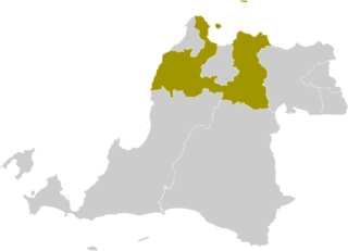
Serang Regency is a regency of Banten province, Indonesia. It is located in the northwest corner of the island of Java. The administrative center of the regency is at Baros, while the capital of the province is the independent municipality of Serang which was split off the regency in 2007.

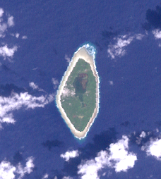
Nanumea is the northwesternmost atoll in the Polynesian nation of Tuvalu, a group of nine coral atolls and islands spread over about 400 miles (640 km) of Pacific Ocean just south of the equator and west of the International Date Line. Nanumea is 4 km2 (1.5 sq mi) with a population of 512 people.
Nanumanga or Nanumaga is a reef island and a district of the Oceanian island nation of Tuvalu. It has a surface area of about 3 km² with a population of 491.

Alonnisos, also transliterated as Alonissos, is a Greek island in the Aegean Sea. After Skiathos and Skopelos it is the third member of the Northern Sporades. It is 3 km (2 mi) (2 nm) east of the island of Skopelos. Alonnisos is also the name of a village on the island, as well as the municipality that encompasses the island and the village.

Streymoy is the largest and most populated island of the Faroe Islands. The capital, Tórshavn, is located on its southeast coast. The name means "island of currents". It also refers to the largest region of the country that also includes the islands of Hestur, Koltur and Nólsoy.

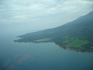
Port Renfrew is a small unincorporated community located on the south shore of Port San Juan, an inlet on the west coast of Vancouver Island in British Columbia, Canada. Port Renfrew has a population of 144 and has been touted as "the Tall Tree Capital of Canada".
Cova Figueira is a city in the southeastern part of the island of Fogo, Cape Verde. In 2010 its population was 1,230, making it the most populated place in the municipality. It is situated 22 km east of the island capital São Filipe. Since 2005, it serves as the seat of Santa Catarina do Fogo Municipality. Its elevation is 480 meters above sea level. The volcano Pico do Fogo is 7.7 km to the northwest. Nearby places include Figueira Pavão in the southwest, Mãe Joana and Estância Roque in the west and Tinteira in the north. Cova Figueira was elevated to a city in 2010.
Lake na is an islet of Nanumea atoll, Tuvalu. Nanumean traditions describe Lakena as being formed when sand spilled from the baskets of two women, Pai and Vau, when they were forced off Nanumea by Tefolaha, the Tongan warrior who became the ancestor of the people of Nanumea.
Lafogaki is an islet of Nanumea atoll, Tuvalu. It is a small uninhabited islet, which Nanumean traditions describe as being formed when sand spilled from the baskets of two women, Pai and Vau, when they were forced off Nanumea by Tefolaha, the Tongan warrior who became the ancestor of the people of Nanumea.
Teaafua a Taepoa or Teaafua-a-Taepoa, is an islet of Nanumea atoll, Tuvalu. It is a small uninhabited islet, which Nanumean traditions describe as being formed when sand spilled from the baskets of two women, Pai and Vau, when they were forced off Nanumea by Tefolaha, the Tongan warrior who became the ancestor of the people of Nanumea.
Te Motu Foliki is an islet of Nanumea atoll, Tuvalu. It is a small uninhabited islet, which Nanumean traditions describe as being formed when sand spilled from the baskets of two women, Pai and Vau, when they were forced off Nanumea by Tefolaha, the Tongan warrior who became the ancestor of the people of Nanumea.

This is a survey of the postage stamps and postal history of Tuvalu.
The Tuvalu Games is a multi-sport event, much like the Pacific Games, with participation exclusively from islands around Tuvalu.

Nanumea Airfield is a former World War II airfield on the island of Nanumea in the Ellice Islands.
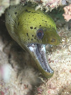
Tuvaluan mythology tells stories of the creation of the islands of Tuvalu and of the founding ancestors of each island. While on some of the islands there are stories of spirits creating the islands, a creation story that is found on many of the islands is that te Pusi mo te Ali created the islands of Tuvalu; te Ali is believed to be the origin of the flat atolls of Tuvalu and te Pusi is the model for the coconut palms that are important in the lives of Tuvaluans. The strength of this belief has the consequence that Moray eel are tapu and are not eaten.
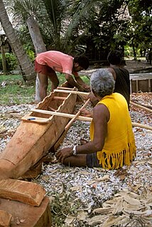
A paopao, is the name used by the Polynesian-speaking inhabitants of the Ellice Islands for their single-outrigger canoes, of which the largest could carry four to six adults. The large double-hulled sailing canoes had ceased to be constructed in the Ellice Islands some time before contact with Europeans.

The coral reefs of Tuvalu consist of three reef islands and six atolls, containing approximately 710 km2 (270 sq mi) of reef platforms. The islands of the Tuvalu archipelago are spread out between the latitude of 5° to 10° south and longitude of 176° to 180°, west of the International Date Line. The islands of Tuvalu are volcanic in origin. On the atolls, an annular reef rim surrounds the lagoon, and may include natural reef channels. The reef islands have a different structure to the atolls, and are described as reef platforms as they are smaller tabular reef platforms that do not have a salt-water lagoon, although they may have a completely closed rim of dry land, with the remnants of a lagoon that has no direct connection to the open sea or that may be drying up.