Related Research Articles

The Eastport Peninsula is a small extension of land into the central part of Bonavista Bay in the Canadian province of Newfoundland and Labrador. The peninsula is adjacent to Terra Nova National Park and contains seven small communities: Eastport, Happy Adventure, Sandy Cove, Salvage, St. Chad's, Burnside and Sandringham.
Ramea is a small village in Newfoundland and Labrador located on Northwest Island, one of a group of five major islands located off the south coast of Newfoundland, Canada. The island is approximately 3.14 km long by 0.93 km wide. The other major islands in the archipelago are Great Island, Middle Island, Harbour Island, and South West Island.
Woody Point is a town located in the heart of Gros Morne National Park, on the western coast of Newfoundland. Situated on Bonne Bay, the Town of Woody Point encompasses three areas: Curzon Village, Woody Point and Winterhouse Brook. It has a total population of 244 residents. Woody Point is a Registered Heritage District and has a waterfront with many heritage buildings and four Registered Newfoundland and Labrador Heritage Structures. The community is served by Route 431.
Bakers Brook is a former Canadian fishing settlement on Bonne Bay, on the island of Newfoundland, in the Canadian province of Newfoundland and Labrador.
Merasheen Island is an island in Newfoundland and Labrador, Canada. With a length of approximately 35 km and a width at its widest point of 9 km, it is situated about 6 km from Presque. It is the largest island in the Placentia Bay.
New-Wes-Valley is a municipality in Newfoundland and Labrador, Canada.

Norris Point is a community in the Canadian province of Newfoundland and Labrador.

Pouch Cove is a town in the Canadian province of Newfoundland and Labrador. The population is 2,063 according to the Canada 2021 Census. It is located on the northeast Avalon Peninsula, 27 kilometres north of St. John's, the province's capital city.

Bonne Bay Marine Station is a marine ecology research and teaching facility on Bonne Bay along Newfoundland's west coast. It offers services to students, researchers, educators and the general public. The station is within Gros Morne National Park, a recognized UNESCO World Heritage Site. The aquarium portion of the facility is open to visitors. Interactive aquariums tours are provided to walk-ins, as well as school and community groups. The tour offers exhibits the latest research while showcasing marine flora and fauna in the station's aquaria and touch tank. Officially opened on 6 Sept, 2002, the Bonne Bay Marine Station is operated by Memorial University of Newfoundland and the Gros Morne Co-operating Association. Funding was provided by Atlantic Canada Opportunities Agency (ACOA) and the Newfoundland and Labrador Provincial Government.

Blow Me Down Provincial Park is a smaller Provincial Park on the west coast of the island of Newfoundland. The park is located on Route 450, about 60 km west of Corner Brook and the Trans-Canada Highway, on a small peninsula between Lark Harbour and York Harbour at the mouth of the Bay of Islands.
Indian Bay is located in Newfoundland, Canada.

Hampden is a town in the Canadian province of Newfoundland and Labrador. The town has a population of 429. Two islands can be seen from the shore of Hampden, Granby Island and Millers Island. The latter is much closer to the town and is the host of a tuberculosis grave-site.

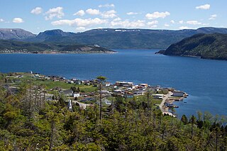
Salvage is a town located on the Eastport Peninsula of the Canadian province of Newfoundland and Labrador. The town had a population of 108 in the Canada 2021 Census.
South Brook is a town in the Canadian province of Newfoundland and Labrador. It is located in the center region of the island of Newfoundland. The town had a population of 420 in 2021, down from 482 in the Canada 2016 Census.

Route 431, also known as Bonne Bay Road, is a short highway almost entirely within Gros Morne National Park on the island of Newfoundland in the Canadian province of Newfoundland and Labrador. It begins at a junction of Route 430 in Wiltondale and terminates at Trout River. It serves the town of Woody Point on Bonne Bay and passes through the communities of Glenburnie, Birchy Head and Winter House Brook.
Wiltondale is a settlement on western Newfoundland in the Canadian province of Newfoundland and Labrador. It is located at the intersection between Route 430 and Route 431.

Division No. 1, Subdivision G is an unorganized subdivision on the Avalon Peninsula in Newfoundland and Labrador, Canada. It is in Division 1 and contains the unincorporated communities of Baccalieu Island, Besom Cove, Bradley's Cove, Burnt Point, Caplin Cove, Daniel's Cove, Grates Cove, Gull Island, Job's Cove, Kingston, Long Beach, Lower Island Cove, Low Point, Northern Bay, Ochre Pit Cove, Red Head Cove, Riverhead, Smooth Cove and Western Bay.
Lockesporte, also spelled Lockesport or Lockport and originally known as Lock's Harbour, was a fishing village and logging community on the eastern coast of Seal Bay, within the much larger Notre Dame Bay, Newfoundland, Canada.
Trammer is an abandoned town in Newfoundland and Labrador, Canada that had a peak population of 15 in 1901.
References
Notes
- ↑ Osmond 1987, p. 233.
- ↑ Crocker 2002, p. 64–65.
- ↑ Crocker 2002, p. 138.
- ↑ Stradiotto & Stradiotto 1988, p. 40.
Sources
- Crocker, Madelyn Jean (2002). The Argin' Ground : a social locus in Trout River circa 1920–present (MA thesis). Memorial University of Newfoundland.
- Stradiotto, John David Patrick; Stradiotto, Martha (1988). The Road to Canada's Wilds. Prentice-Hall Canada. ISBN 9780137814695.
- Osmond, Roy Michael (1987). Families of the South-arm of Bonne Bay, 1800's–930's. R.M. Osmond.