Related Research Articles

Inyo County is a county in the eastern central part of the U.S. state of California, located between the Sierra Nevada mountains and the state of Nevada. In the 2010 census, the population was 18,546. The county seat is Independence. Inyo County is on the east side of the Sierra Nevada and southeast of Yosemite National Park in Central California. It contains the Owens River Valley; it is flanked to the west by the Sierra Nevada and to the east by the White Mountains and the Inyo Mountains. With an area of 10,192 square miles (26,397 km2), Inyo County is the second-largest county by area in California, after San Bernardino County. Almost one-half of that area is within Death Valley National Park. However, with a population density of 1.8 people per square mile, it also has the second-lowest population density in California, after Alpine County.

Big Pine is a census-designated place (CDP) in Inyo County, California, United States. Big Pine is located approximately 15 miles (24 km) south-southeast of Bishop, at an elevation of 3,989 feet (1,216 m). The population was 1,756 at the 2010 census, up from 1,350 at the 2000 census. The Big Pine Band of Owens Valley Paiute Shoshone Indians of the Big Pine Reservation operates their tribal headquarters from here.

Lone Pine is a census designated place (CDP) in Inyo County, California, United States. Lone Pine is located 16 miles (26 km) south-southeast of Independence, at an elevation of 3,727 feet. The population was 2,035 at the 2010 census, up from 1,655 at the 2000 census. The town is located in the Owens Valley, near the Alabama Hills and Mount Whitney, between the eastern peaks of the Sierra Nevada to the west and the Inyo Mountains to the east. From possible choices of urban, rural, and frontier, the Census Bureau identifies this area as "frontier". The local hospital, Southern Inyo Hospital, offers standby emergency services. The town is named after a solitary pine tree that once existed at the mouth of Lone Pine Canyon. On March 26, 1872, the very large Lone Pine earthquake destroyed most of the town and killed 27 of its 250 to 300 residents.

The Alabama Hills are a range of hills and rock formations near the eastern slope of the Sierra Nevada in the Owens Valley, west of Lone Pine in Inyo County, California.

Owens Valley is an arid valley of the Owens River in eastern California in the United States. It is located to the east of the Sierra Nevada, west of the White Mountains and Inyo Mountains, and north of the Mojave Desert. It sits on the west edge of the Great Basin. The mountain peaks on the West side reach above 14,000 feet (4,300 m) in elevation, while the floor of the Owens Valley is about 4,000 feet (1,200 m), making the valley the deepest in the United States. The Sierra Nevada casts the valley in a rain shadow, which makes Owens Valley "the Land of Little Rain." The bed of Owens Lake, now a predominantly dry endorheic alkali flat, sits on the southern end of the valley.

The 1872 Owens Valley earthquake – also known as the Lone Pine earthquake – struck on March 26 at 02:30 local time in the Owens Valley, with the epicenter near the town of Lone Pine. Its magnitude has been estimated at Mw 7.4 to 7.9, with a maximum Mercalli Intensity of X (Extreme). It was one of the largest earthquakes to hit California in recorded history and was similar in size to the 1906 San Francisco earthquake. Twenty-seven people were killed and fifty-six were injured.

Inyo National Forest is a United States National Forest covering parts of the eastern Sierra Nevada of California and the White Mountains of California and Nevada. The forest hosts several superlatives, including Mount Whitney, the highest point in the contiguous United States; Boundary Peak, highest point in Nevada; and the Ancient Bristlecone Pine Forest that protects the oldest trees in the world. The forest, encompassing much of Owens Valley, was established by Theodore Roosevelt as a way of sectioning off land to accommodate the Los Angeles Aqueduct project in 1907, making the Inyo National Forest one of the least wooded forests in the United States' system.

Manzanar was a town in Inyo County, California, founded by water engineer and land developer George Chaffey.
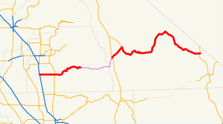
State Route 190 is a state highway in the U.S. state of California that is split into two parts by the Sierra Nevada. The western portion begins at Tipton at a junction with State Route 99 and heads east towards Porterville before ending at Quaking Aspen in the Sequoia National Forest. The eastern portion begins at US 395 at Olancha, heads east through Death Valley National Park, and ends at State Route 127 at Death Valley Junction. The 43.0-mile (69.2 km) portion over the Sierra Nevada remains unconstructed, and the California Department of Transportation (Caltrans) has no plans to build it through the wilderness areas. SR 190 is a National Scenic Byway known as the Death Valley Scenic Byway.
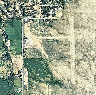
Lone Pine Airport is a public airport located one mile (1.6 km) southeast of Lone Pine serving Inyo County, California, United States. The airport has two runways and is mostly used for general aviation. Charts: San Francisco; L5.

The Mount Whitney Trail is a trail that climbs Mount Whitney. It starts at Whitney Portal, 13 miles (21 km) west of the town of Lone Pine, California. The hike is about 22 mi (35 km) round trip, with an elevation gain of over 6,100 feet (1,860 m). It is an extremely popular trail, and its access is restricted by quotas from May to October.
Lone Pine High School was established in 1916. The first graduating class of the school was in 1919. The class of 2018 will be the 100th graduating class in Lone Pine High Schools history. It is the only high school in the Census-designated place (CDP) of Lone Pine, California. The school colors are purple and gold, and the mascot is the Golden Eagle
Little Lake is a former settlement in Inyo County that lies just off U.S. Route 395 on Little Lake Road.

Owenyo was an unincorporated community in Inyo County, California. It was located on the Southern Pacific Railroad 5 miles (8 km) north of Lone Pine, at an elevation of 3697 feet. The town was abandoned in the 1960s, and all that remain now are a few traces of building foundations. There are no standing structures and no inhabitants in or anywhere near Owenyo, which remains on 21st century maps only as a reference point along the bleak, unkept and itself abandoned Owenyo-Lone Pine Road which runs about two miles east of, and running parallel with, Federal Highway 395.
Reward was an mining site in Inyo County, California. It is located on the west side of the Inyo Mountains 9.5 miles (15 km) north of Lone Pine, at an elevation of 3865 feet.
Bend City is a former settlement in Inyo County, California. It was located on the Owens River near the modern-day town of Kearsarge. Founded in the 1863, Bend City was originally a mining camp. Bend City was the site of the first county bridge spanning the Owens River. The 1872 Lone Pine earthquake changed the course of the river away from the townsite, which had already declined. The site is now registered as California Historical Landmark #209.
The Paiute-Shoshone Indians of the Lone Pine Community of the Lone Pine Reservation is a federally recognized tribe of Mono and Timbisha Native American Indians near Lone Pine in Inyo County, California. They are related to the Owens Valley Paiute.

Lone Pine Peak is located on the east side of the Sierra Nevada range just west of the town of Lone Pine, California in Inyo County, in eastern California in the southwestern United States. The summit marks the eastern boundary of the John Muir Wilderness in the Inyo National Forest. Lone Pine Peak is the mountain in the photo for the default desktop of macOS Sierra.
The Union Wash Formation is a geologic formation in the Inyo Mountains, east of Lone Pine in Inyo County, California.

The Georges Fire was a wildfire in Inyo County, California in the United States. The fire was reported on July 8, 2018 in a rural area north of Lone Pine and west of Manzanar. The fire was started by a lightning strike and impacted recreational activities in the Inyo National Forest, as well as the habitat for Sierra Nevada bighorn sheep, an endangered species. The fire burned 2,883 acres (12 km2), before burning out on July 18.
References
- ↑ "School Sites". lpusd-ca.schoolloop.com. Retrieved 2021-06-01.