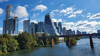
Austin is the capital of the U.S. state of Texas, as well as the seat and most populous city of Travis County, with portions extending into Hays and Williamson counties. Incorporated on December 27, 1839, it is the 10th most populous city in the United States, the fourth most populous city in the state after Dallas, San Antonio and Houston, and the second most populous state capital city after Phoenix, the capital of Arizona. It has been one of the fastest growing large cities in the United States since 2010. Downtown Austin and Downtown San Antonio are approximately 80 miles (129 km) apart, and both fall along the Interstate 35 corridor. This combined metropolitan region of San Antonio–Austin has approximately 5 million people. Austin is the southernmost state capital in the contiguous United States and is considered a Beta-level global city as categorized by the Globalization and World Cities Research Network.

Infrastructure is the set of facilities and systems that serve a country, city, or other area, and encompasses the services and facilities necessary for its economy, households and firms to function. Infrastructure is composed of public and private physical structures such as roads, railways, bridges, tunnels, water supply, sewers, electrical grids, and telecommunications. In general, infrastructure has been defined as "the physical components of interrelated systems providing commodities and services essential to enable, sustain, or enhance societal living conditions" and maintain the surrounding environment.
The Trans-Texas Corridor (TTC) was a proposal for a transportation network in the U.S. State of Texas that was conceived to be composed of a new kind of transportation modality known as supercorridors. The TTC was initially proposed in 2001 and after considerable controversy was discontinued by 2010 in the planning and early construction stages.
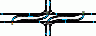
A superstreet, also known as a restricted crossing U-turn (RCUT), J-turn, or reduced conflict intersection (RCI), is a type of road intersection that is a variation of the Michigan left. In this configuration, in contrast to the Michigan left, traffic on the minor road is not permitted to proceed straight across the major road or highway. Drivers on the minor road wishing to turn left or go straight must turn right onto the major road, then, a short distance away, queue (wait) into a designated U-turn lane in the median. When traffic clears, they complete the U-turn and then either go straight or make a right turn when they intersect the other half of the minor road.

Interstate 14 (I-14), also known as the 14th Amendment Highway, the Gulf Coast Strategic Highway, and the Central Texas Corridor, is an Interstate Highway that is currently located entirely in Central Texas, following US Highway 190 (US 190). The portion of the route that has been constructed and signed to date, the Central Texas Corridor along US 190 west of I-35 was officially designated as I-14 by the Fixing America's Surface Transportation Act, signed by President Barack Obama on December 14, 2015.

Loop 1 is a freeway which provides access to the west side of Austin in the U.S. state of Texas. It is named Mopac Expressway after the Missouri Pacific Railroad. Local residents almost always use the name "MoPac" rather than calling the road by its number, which can cause much confusion, for few signs along the road use this name.

State Highway 130 (SH 130), also known as the Pickle Parkway, is a freeway from Interstate 35 (I-35) in San Antonio along I-410 and I-10 to east of Seguin, then north as a toll road from there to I-35 north of Georgetown. SH 130 runs in a 91-mile (146 km) corridor east and south of Austin. The route parallels I-35 and is intended to relieve the Interstate's traffic volume through the San Antonio–Austin corridor by serving as an alternate route.

State Highway 45 is a freeway loop around Austin, Texas, that exists in two open segments. The official designation of SH 45 is such to form a complete loop around Austin, a distance of roughly 80 miles (130 km).

State Highway 71 is a Texas state highway that runs 253 miles (407 km). The northern terminus is at US 87 and US 377 south of Brady and its southern terminus is at SH 35 near Blessing. This highway is designated the "10th Mountain Division Highway" from SH 95 to Interstate 35.

State Highway 151, also known as the Raymond E. Stotzer Jr. Freeway, is a 10.7-mile (17.2 km) state highway in the U.S. state of Texas that runs from Loop 1604 to U.S. Highway 90 (US 90) in San Antonio. SH 151 is a limited-access freeway for its entire length with the exception of its junction with Loop 1604 at its western terminus where a traffic light controls the junction. The routing of the freeway was first conceived in 1983 and construction was conducted in phases through the 1980s and 1990s until completion in 2004. The freeway provides access to the western part of San Antonio, the SeaWorld San Antonio theme park, Chase, Northwest Vista College, and the future site of a Microsoft data center.

The Central Texas Regional Mobility Authority is an independent government agency created in 2002 to improve the transportation system in Travis and Williamson Counties in Texas. The Mobility Authority is headquartered at 3300 N. IH 35 in Austin.

State Highway 211 (SH 211), also known as the Texas Research Parkway and the Hill Country Parkway, is an 18.8-mile (30.3 km) state highway west of the city of San Antonio in the U.S. state of Texas. It runs from U.S. Highway 90 (US 90) to SH 16, crossing between Bexar County and Medina County. Designated in 1986 as an access route to the Texas Research Park, the route was composed of two disconnected sections—a southern segment from US 90 to Farm to Market Road 1957 (FM 1957) and a northern segment from FM 471 to SH 16—before the gap was closed in 2022.

The Lamar Boulevard Bridge is a historic arch bridge carrying Texas State Highway Loop 343 over Lady Bird Lake in downtown Austin, Texas, United States. The bridge features six open-spandrel concrete arches spanning 659 feet (201 m) and carries tens of thousands of vehicles daily across the lake. Completed in 1942, the Lamar Boulevard Bridge was the second permanent bridge to cross the Colorado River, and one of the last Art Deco-style open-spandrel concrete arch bridges built in Texas. The bridge was named an Austin Landmark in 1993 and added to the National Register of Historic Places in 1994.

U.S. Route 183 (US 183) is a north-south U.S. highway that begins in Texas in Refugio at an intersection with US 77 concurrent with US 77 Alt. The highway runs through many small communities with Austin being the only major city along its route. The highway exits Texas concurrent with US 70, crossing into Oklahoma.

Interstate 35 (I-35) is a major north–south Interstate Highway that runs from Laredo, Texas near the Mexican border to Duluth, Minnesota. In Texas, the highway begins in Laredo and runs north to the Red River north of Gainesville, where it crosses into Oklahoma. Along its route, it passes through the cities of San Antonio, Austin, and Waco before splitting into two branch routes just north of Hillsboro: I-35E heads northeast through Dallas, while I-35W turns northwest to run through Fort Worth. The two branches rejoin in Denton to again form I-35, which continues to the Oklahoma state line. The exit numbers for I-35E maintain the sequence of exit numbers from the southern segment of I-35, and the northern segment of I-35 follows on from the sequence of exit numbers from I-35E. I-35W maintains its own sequence of exit numbers.

Farm to Market Road 969 is a 28.95-mile (46.59 km) farm-to-market road located in Travis and Bastrop counties in the U.S. state of Texas.
There are approximately 25 current toll roads in the state of Texas. Toll roads are more common in Texas than in many other U.S. states, since the relatively low revenues from the state's gasoline tax limits highway planners' means to fund the construction and operation of highways.

Wiss, Janney, Elstner Associates, Inc. (WJE) is an American corporation of architects, engineers, and materials scientists specializing in the investigation, analysis, testing, and design of repairs for historic and contemporary buildings and structures. Founded in 1956, WJE is headquartered in Northbrook, Illinois, and has over 600 professionals in twenty offices across the United States. WJE personnel are specialized in architectural, structural, and civil engineering; materials conservation, chemistry and petrography, and testing and instrumentation.
The Center for Transportation Research (CTR) is a research center affiliated with the Cockrell School of Engineering's Department of Civil, Architectural, and Environmental Engineering at The University of Texas at Austin in Austin, Texas. CTR is a research institution focused on transportation research and education.