The Metropolitan Borough of Rochdale is a metropolitan borough of Greater Manchester in England. Its largest town is Rochdale and the wider borough covers other outlying towns and villages, including Middleton, Heywood, Milnrow and Littleborough with a population of 223,773 at the 2021 census. It is the ninth-largest district by population in Greater Manchester.

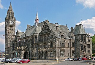
Rochdale is a town in Greater Manchester, England, and the administrative centre of the Metropolitan Borough of Rochdale. In the 2021 census the town had a population of 111,261, compared to 223,773 for the wider borough. Rochdale is in the foothills of the South Pennines and lies in the dale (valley) of the River Roch, 5 miles (8 km) northwest of Oldham and 10 miles (16 km) northeast of Manchester.

Milnrow is a town within the Metropolitan Borough of Rochdale, in Greater Manchester, England. It lies on the River Beal at the foothills of the South Pennines, and forms a continuous urban area with Rochdale. It is 2 miles (3.2 km) east of Rochdale town centre, 10 miles (16.1 km) north-northeast of Manchester, and spans from Windy Hill in the east to the Rochdale Canal in the west. Milnrow is adjacent to junction 21 of the M62 motorway, and includes the village of Newhey, and hamlets at Tunshill and Ogden.

Middleton is a town in the Metropolitan Borough of Rochdale, Greater Manchester, England, on the River Irk 5 miles (8.0 km) southwest of Rochdale and 5 miles (8.0 km) northeast of Manchester city centre. Middleton had a population of 42,972 at the 2011 Census. It lies on the northern edge of Manchester, with Blackley to the south and Moston to the south east.
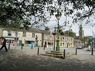
Littleborough is a village in the Metropolitan Borough of Rochdale, Greater Manchester, England, in the upper Roch Valley by the foothills of the South Pennines, 3 miles (4.8 km) northeast of Rochdale and 13 miles (20.9 km) northeast of Manchester; Milnrow and the M62 motorway are to the south, and the rural uplands of Blackstone Edge to the east. According to the 2001 census, Littleborough, and its suburbs of Calderbrook, Shore and Smithy Bridge, had a population of 13,807.

Prestwich is a town in the Metropolitan Borough of Bury, Greater Manchester, England, 3.3 miles (5.3 km) north of Manchester city centre, 3.1 miles (5 km) north of Salford and 4.7 miles (7.6 km) south of Bury.
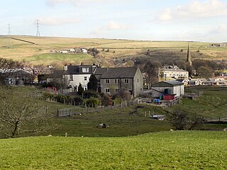
Wardle is a village near Littleborough within the Metropolitan Borough of Rochdale, in Greater Manchester, England. It lies amongst the foothills of the South Pennines, 1.8 miles (2.9 km) east-southeast of Whitworth, 2.5 miles (4 km) north-northwest of Rochdale and 12 miles (19 km) north-northeast of the city of Manchester.

Blackstone Edge is a gritstone escarpment at 472 metres (1,549 ft) above sea level in the Pennine hills surrounded by moorland on the boundary between Greater Manchester and West Yorkshire in England.

Newhey is a village near the town of Milnrow in the Metropolitan Borough of Rochdale, in Greater Manchester, England. It lies at the foot of the South Pennines, by Junction 21 of the M62 motorway and on the River Beal, 3 miles (4.8 km) east-southeast of Rochdale, 10 miles (16.1 km) northeast of Manchester.

Butterworth Hall Brook is a water course in Greater Manchester, North-West England, which flows through the village of Milnrow and is a tributary of the River Beal.

Piethorne Brook is a watercourse in Greater Manchester. It is a tributary of the River Beal.

Stanney Brook is a watercourse in Greater Manchester, England. It originates in the Burnedge area of Shaw and Crompton, and flows through Milnrow into Rochdale before joining the River Roch at Newbold Brow. Alone among the watercourses of Milnrow and Newhey, it does not pass through the centre of either village, and flows directly into the River Roch, rather than first into the River Beal. Its name derives from the Lancashire dialect word "stanner", a ridge of stones. It is also unusual in that the borough in which it rises, changes, depending on the wetness of surrounding moorland. The brook drops 100 metres in a little over 5.5 kilometres, or 330feet in 3.5 miles. It is culverted four times, generally is only 60 cm (2 ft) wide, and rarely exceeds 90 cm (3 ft) in width at any point.

Habergham Eaves is a civil parish in the borough of Burnley, in Lancashire, England. The parish consists of a rural area south of Burnley, and suburban areas on the outskirts of the town, including a large industrial estate in the north-west corner of the parish. Habergham is also the name of an area west of Burnley, although it is no longer within the parish. According to the United Kingdom Census 2011, the parish has a population of 1,466.

Denshaw is a village in the civil parish of Saddleworth in the Metropolitan Borough of Oldham, in Greater Manchester, England. It lies by the source of the River Tame, high amongst the Pennines above the village of Delph, 4.6 miles (7.4 km) northeast of Oldham,3.3 miles (5.3 km) north-northwest of Uppermill and Shaw and Crompton. It has a population of around 500.
Broadclough – historically Broad Clough – is a village located to the north of Bacup, previously having been a part of the old borough of Bacup and now with Rossendale borough of Lancashire and part of the Greenclough Ward. It is part of the Rossendale and Darwen constituency, with Jake Berry having been the Member of Parliament since 2010. Like much of Bacup, Broadclough is rapidly becoming a commuter area for cities and towns such as Manchester, Burnley, Accrington, Preston, Blackburn, Rochdale.
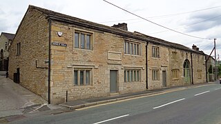
Littleborough is a town in the Metropolitan Borough of Rochdale, Greater Manchester, England, and it is unparished. The town, its suburbs of Calderbrook and Smithy Bridge, and the surrounding countryside contain 79 listed buildings that are recorded in the National Heritage List for England. Of these, five are listed at Grade II*, the middle grade, and the others are at Grade II, the lowest grade. The area is largely rural, and most of the listed buildings are houses and associated structures, farmhouses, and farm buildings. Following the Industrial Revolution textile mills were built, some of which remain and are listed. The Rochdale Canal passes through the area and bridges and locks associated with it are listed. Also passing through the area was the Manchester and Leeds Railway, and structures associated with it are listed. The other listed buildings include churches, public houses, a former toll house, a bandstand, a drinking fountain, and two war memorials.
Wardle is a village in the Metropolitan Borough of Rochdale, Greater Manchester, England, and it is unparished. The village, together with the nearby settlement of Smallbridge and the surrounding countryside, contains 27 listed buildings that are recorded in the National Heritage List for England. All the listed buildings are designated at Grade II, the lowest of the three grades, which is applied to "buildings of national importance and special interest". The area is largely rural and agricultural, although the textile industry came to the town as a result of the Industrial Revolution. Included in the listed buildings are houses containing multi-light mullioned weavers' windows, and a mill. Most of the listed buildings are houses and associated structures, farmhouses and farm buildings. The other listed buildings include churches, a public house, a bridge and two war memorials.
Handle Hall is a Grade II listed privately owned historic house in Calderbrook, Littleborough, Greater Manchester.
