Division No. 1, Subdivision A is an unorganized subdivision on the Avalon Peninsula in Newfoundland and Labrador, Canada. It is in Division No. 1, and lies between Trinity Bay and Placentia Bay.

Division 1, Newfoundland and Labrador is a census division covering the entire Avalon Peninsula including the Isthmus of Avalon of the Canadian province of Newfoundland and Labrador. Like all census divisions in Newfoundland and Labrador, but unlike the census divisions of some other provinces, the division exists only as a statistical division for census data, and is not a political entity.
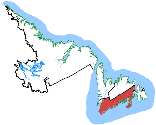
Random—Burin—St. George's was a federal electoral district in Newfoundland and Labrador, Canada, that was represented in the House of Commons of Canada from 2004 to 2015.
The Burin Peninsula is a peninsula located on the south coast of the island of Newfoundland in the province of Newfoundland and Labrador. Marystown is the largest population centre on the peninsula.

The East Coast Trail (ECT) is a long-distance coastal footpath located in the Canadian province of Newfoundland and Labrador. It is a developed trail over 336 kilometres (209 mi) long, creation of which began in 1994. It is made up of 25 linked wilderness paths and passes through more than 30 communities. It was named one of the best adventure destinations by National Geographic in 2012 and is extended and improved yearly.
Merasheen Island is an island in Newfoundland and Labrador, Canada. With a length of approximately 35 km and a width at its widest point of 9 km, it is situated about 6 km from Presque. It is the largest island in the Placentia Bay.

The Drake House is a two-story house with a low-pitched gable roof. It is located at 319 Main Road, Arnold's Cove, Newfoundland and Labrador, Canada.
Darby's Harbour is a locality and former settlement located southwest of Swift Current in Paradise Sound, Placentia Bay, Newfoundland, Canada. It had a post office in 1940. The 1935 population was 21, but by 1990 it was uninhabited.
Oderin Island is an island in the province of Newfoundland and Labrador in western Placentia Bay, located about 30 km northeast of Marystown. Oderin was originally settled by the French who considered it an important fishing post and had fortified it against the English. The name was originally Audierne, named after a town in France. In 1712, the French authorities in Placentia ordered all the buildings and fishing premises to be burned or destroyed, in part to deny to English the use of the site but also as retribution against the local French merchant Lafosse who had deserted to and collaborated with the English. This did not happen, however, as English Captain Tavener's second report indicates that Lafosse's abandoned wife was still present in May 1718 and running a prosperous operation.

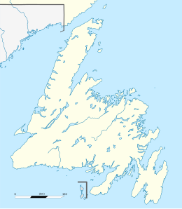
The Cape Shore is a region on the southwestern portion of the Avalon Peninsula on the island of Newfoundland, Canada.
Harbour Buffett was a Way Office established in 1854. The first Waymaster was Thomas E. Collett. It was changed to a Post Office on May 30th 1891. It was only served by the Canadian National Railway in 1953.
The Connaigre Peninsula is a Canadian peninsula located on the south coast of the island of Newfoundland in the province of Newfoundland and Labrador. Harbour Breton is the largest population centre on the peninsula.
Ship Harbour is a community in Newfoundland and Labrador, Canada located on the eastern shore of Placentia Bay.
Lodge Bay is a local service district and designated place in the Canadian province of Newfoundland and Labrador. It is on the southeast coast of Labrador. Encompassing a population of less than one hundred residents, the community has uniquely evolved from both early European colonization of Labrador, and the inimitable patterns of land and resource use by the migratory Inuit population. The name Lodge Bay originated from the title Ranger Lodge, which was the name given to the area by trader and explorer, Captain George Cartwright in the late 18th century. "Ranger" was the name of the wooden-mercantile ship Cartwright used to trade, map and explore the Labrador coast, while "Lodge" was the name given to English hunting camps in Great Britain at that time.
Haystack was a former fishing settlement located on the northern portion of Long Island, Placentia Bay of the island of Newfoundland in the province of Newfoundland and Labrador, Canada. People from the community freely chose to move to other places in the province during the resettlement program of the 1950s and 60s. Unlike most communities, residents were not paid to leave the community.
Division No. 1, Subdivision B is an unorganized subdivision on the Avalon Peninsula in Newfoundland and Labrador, Canada. It is in Division 1 and contains the unorganized communities of Iona, Little Barasway, Placentia Junction, Point Verde and Ship Harbour.

Division No. 1, Subdivision G is an unorganized subdivision on the Avalon Peninsula in Newfoundland and Labrador, Canada. It is in Division 1 and contains the unincorporated communities of Baccalieu Island, Besom Cove, Bradley's Cove, Burnt Point, Caplin Cove, Daniel's Cove, Grates Cove, Gull Island, Job's Cove, Kingston, Long Beach, Lower Island Cove, Low Point, Northern Bay, Ochre Pit Cove, Red Head Cove, Riverhead, Smooth Cove and Western Bay.
Winter House Cove was a fishing village on the eastern coast of Seal Bay, within the much larger Notre Dame Bay, Newfoundland, Canada.
Lockesporte, also spelled Lockesport or Lockport and originally known as Lock's Harbour, was a fishing village and logging community on the eastern coast of Seal Bay, within the much larger Notre Dame Bay, Newfoundland, Canada.
Pays Cove is an abandoned town in Newfoundland and Labrador, Canada that had a peak population of 11 in 1935.