
Parry Sound is a town in Ontario, Canada, located on the eastern shore of the sound after which it is named. Parry Sound is located 160 km (99 mi) south of Sudbury and 225 km (140 mi) north of Toronto. It is a single tier government located in the territorial District of Parry Sound which has no second tier County, Regional or District level of government. Parry Sound is a popular cottage country region for Southern Ontario residents. It also has the world's deepest natural freshwater port.

Parry Sound—Muskoka is a federal electoral district in Ontario, Canada, that has been represented in the House of Commons of Canada since 1949.

Parry Sound—Muskoka is a provincial electoral district in the Canadian province of Ontario.
Kearney is a town and municipality in the Almaguin Highlands region of Parry Sound District of Ontario, Canada. With a landmass of 528 square kilometres and a year-round population of 974 in the Canada 2021 Census, Kearney claims to be the "Biggest Little Town in Ontario."
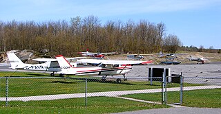
Parry Sound Area Municipal Airport, commonly known as Parry Sound Airport, is a Regional airport located in Seguin Township within the District of Parry Sound in Ontario, Canada. It is used by Civil aviation, Air ambulances, Hydro One Helicopters, the Ontario Provincial Police, and Search & rescue. It is located 12 nautical miles southeast of Parry Sound, Ontario, Canada.

Secondary Highway 518, commonly referred to as Highway 518, is a provincially maintained secondary highway in the Canadian province of Ontario. Highway 518 spans 72.7 kilometres (45.2 mi) between Parry Sound and Kearney. It serves as one of the many links between Highway 400 and Highway 11. The highway was assumed in 1956, and has remained generally unchanged since, aside from being truncated slightly at both ends.
The Canada Atlantic Railway (CAR) was a North American railway located in Ontario, southwestern Quebec and northern Vermont. It connected Georgian Bay on Lake Huron with the northern end of Lake Champlain via Ottawa. It was formed in 1879 through a merger of two separate railway companies that John Rudolphus Booth had purchased, and reached its full extent in 1899 through a third company that he had created. The CAR was owned by Booth for several years after its completion until he agreed to sell it to the Grand Trunk Railway (GTR) in 1904.

Sand Lake(French: lac Sand) is a lake in the town of Kearney, Almaguin Highlands, Parry Sound District, Ontario, Canada. An unincorporated community of Sand Lake, Ontario could be found just north of Sand Lake prior to the amalgamation with Kearney in 1979. Sand Lake is also host to only one camp, and much of the shore of the lake is Precambrian rock of the Canadian Shield. There are only a few occurrences of sandy beach around the lake shoreline due largely to runoff water erosion carrying sand from creeks from the surrounding elevated rocky terrain. However, a good portion of the shallow waters around the shore are sand as the name of the lake suggests.

The Almaguin Highlands Region in Ontario, Canada, covers approximately 5,200 km2 (2,000 sq mi) comprising the eastern half of Parry Sound District. It is bounded by Muskoka in the south, and by Lake Nipissing and Nipissing District in the north. The eastern edge abuts the western boundary of Algonquin Provincial Park, whereas the western boundary of the Almaguin Highlands is generally regarded to be the mid east-west point of Parry Sound District. Originally derived from the words Algonquin, Magnetawan, and Seguin. the name Almaguin is now used to describe the marketing region of East Parry Sound.
Ravensworth is an unincorporated place and former railway point in the municipality of Kearney, Parry Sound District in Central Ontario, Canada. It is located at the present day intersection of Rain Lake Road and the north end of Aholas Drive, about 8 kilometres (5 mi) east of the centre of Kearney. The community was once a station on the Ottawa, Arnprior and Parry Sound Railway, but it was decommissioned in 1959. The railbed was converted into Rain Lake Road to allow continued access to Ravensworth and other communities along the route.
Canoe Lake is a lake in Parry Sound District, Ontario, Canada. The lake is about 1,200 metres (3,937 ft) long and 500 metres (1,640 ft) wide, and the primary inflow and outflow is Canoe Creek, which drains into the South Channel of Georgian Bay, Lake Huron.
Snowshoe Lake is a lake in the Lake Huron drainage basin 2 kilometres (1.2 mi) northeast of the community of Burton and the Canadian National Railway line in Whitestone, Parry Sound District, Ontario, Canada. It is about 500 metres (1,640 ft) long and 180 metres (591 ft) wide, and lies at an elevation of 236 metres (774 ft). The lake drains via unnamed creek to Doctor Lake and into the South Branch of the Magnetawan River, and then either through the Magnetawan, or Harris and Naiscoot Rivers into Lake Huron.
Snowshoe Lake is a lake in the Lake Huron drainage basin in Whitestone, Parry Sound District, Ontario, Canada, about 11 kilometres (7 mi) north of the community of Maple Island, and 15 kilometres (9 mi) southeast of the community of Arnstein. It is about 2.1 kilometres (1.3 mi) long and 1.1 kilometres (0.7 mi) wide and lies at an elevation of 285 metres (935 ft). The lake drains via an unnamed creek to the Kimikong River and then via the Pickerel and French rivers into Lake Huron.
Snowshoe Lake is a lake in the Lake Huron drainage basin in Kearney, Almaguin Highlands, Parry Sound, Ontario, Canada. The lake is 6 kilometres (3.7 mi) east of the community of Ravenscroft, just south of the access road to Rain Lake in Algonquin Provincial Park, and 5.5 kilometres (3.4 mi) west of the park boundary. It is about 1.5 kilometres (0.9 mi) long and 0.5 kilometres (0.3 mi) wide, and lies at an elevation of 424 metres (1,391 ft). The primary inflow is an unnamed creek from Ink Lake, and the primary outflow is an unnamed creek to Cripple Lake, which flows via Cripple Creek, the Big East River, the Muskoka River and the Moon and Musquash rivers into Lake Huron.
Daisy Lake is a lake in the geographic townships of Butt and McCraney in the Unorganized South Part of Nipissing District, Ontario, Canada. The lake is in the Ottawa River drainage basin and is entirely within Algonquin Provincial Park.
Tonawanda Creek is a creek in Central Ontario, Canada. It is part of the Great Lakes Basin and is a right tributary of the Big East River.
Long Lake is a small lake in northeastern Ontario, Canada. It is located in the municipality of East Ferris in Nipissing District.
Bob's Lake is a lake in geographic Patterson Township in the Unorganized Centre Part of Parry Sound District in Central Ontario, Canada. It is in the Great Lakes Basin, and the nearest community is Restoule, 6 kilometres (4 mi) to the east. It is located in the Almaguin Highlands.
The Three Sisters are a trio of lakes connected by short creeks in Nipissing District, Ontario, Canada, about 15 km (9.3 mi) north of the village of Temagami. They are arranged in a north–south trending line with a maximum length of about 2.5 km (1.6 mi). This group of lakes is situated in the geographic Best Township, which makes up part of the Municipality of Temagami.
