
Zambia is a landlocked country located in Southern Africa, to the east of Angola. It has a total area of 752,618 square kilometres, of which 9 220 km2 is water.

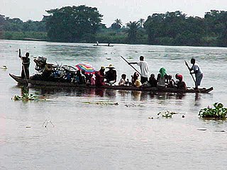
The Congo River, formerly also known as the Zaire River, is the second longest river in Africa, shorter only than the Nile, as well as the second largest river in the world by discharge volume, following only the Amazon. It is also the world's deepest recorded river, with measured depths in excess of 220 m (720 ft). The Congo-Lualaba-Chambeshi River system has an overall length of 4,700 km (2,920 mi), which makes it the world's ninth-longest river. The Chambeshi is a tributary of the Lualaba River, and Lualaba is the name of the Congo River upstream of Boyoma Falls, extending for 1,800 km (1,120 mi).
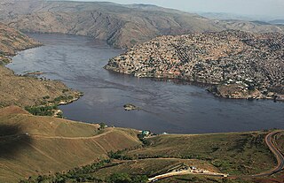
Matadi is the chief sea port of the Democratic Republic of the Congo and the capital of the Kongo Central province, adjacent to the border with Angola. It had a population of 245,862 (2004). Matadi is situated on the left bank of the Congo River, 148 km (92 mi) from the mouth and 8 km (5.0 mi) below the last navigable point before the rapids that make the river impassable for a long stretch upriver. It was founded by Sir Henry Morton Stanley in 1879.

The Zambezi River is the fourth-longest river in Africa, the longest east-flowing river in Africa and the largest flowing into the Indian Ocean from Africa. The area of its basin is 1,390,000 square kilometres (540,000 sq mi), slightly less than half of the Nile's. The 2,574-kilometre-long river (1,599 mi) rises in Zambia and flows through eastern Angola, along the north-eastern border of Namibia and the northern border of Botswana, then along the border between Zambia and Zimbabwe to Mozambique, where it crosses the country to empty into the Indian Ocean.

Zaire is one of the 18 provinces of Angola. It occupies 40,130 square kilometres (15,490 sq mi) in the north west of the country and had a population of 594,428 inhabitants in 2014. It is bordered on the west by the Atlantic Ocean, on the north by the Democratic Republic of Congo, on the east by the Uíge Province, and on the south by the Bengo Province.

Cuando Cubango is a province of Angola and it has an area of 199,049 km2 and a population of 534,002 in 2014. Menongue is the capital of the province. The governor of the province is Júlio Marcelino Vieira Bessa since July 2019.

The Cuanza River, also known as the Coanza, the Quanza, and the Kwanza, is one of the longest rivers in Angola. It empties into the Atlantic Ocean just south of the national capital Luanda.
The Cuando River is a river in south-central Africa flowing through Angola and Namibia's Caprivi Strip and into the Linyanti Swamp on the northern border of Botswana. Below the swamp, the river is called the Linyanti River and, farther east, the Chobe River, before it flows into the Zambezi River.
The Kwilu River is a major river that originates in Angola and flows north through Bandundu Province in the Democratic Republic of the Congo (DRC) to the city of Bandundu, where it joins the Kwango River just before this stream enters the Kasai River. In the DRC the river flows past the towns of Gungu, Kikwit, Bulungu, Bagata, Rutherfordia and Bandundu. Lusanga, formerly Leverville, lies at the location where the Kwenge River joins the Kwilu, between Kikwit and Bulungu.

Rail transport in Angola consists of three separate Cape gauge lines that do not connect: the northern Luanda Railway, the central Benguela Railway, and the southern Moçâmedes Railway (southern). The lines each connect the Atlantic coast to the interior of the country. A fourth system once linked Gunza and Gabala but is no longer operational.

Chiloglanis is a genus of upside-down catfishes native to Africa. These species have modified lips and barbels that form a suckermouth. They also have a naked (scaleless) body. Sexual dimorphism has been reported in Chiloglanis. The adult males of many of these species have elongate anal and caudal fins. Also, males may have an enlarged humeral process.

Quiçama National Park, also known as Kissama National Park, is a national park in northwestern Angola.
Luengue-Luiana National Park is a national park in Angola.

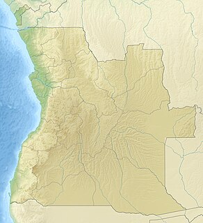
Angola is located on the western Atlantic Coast of Central Africa between Namibia and the Republic of the Congo. It also is bordered by the Democratic Republic of the Congo and Zambia to the east. The country consists of a sparsely watered and somewhat sterile coastal plain extending inland for a distance varying from 50 to 160 km. Slightly inland and parallel to the coast is a belt of hills and mountains and behind those a large plateau. The total land size is 1,246,700 km2 (481,400 sq mi). It has an Exclusive Economic Zone of 518,433 km2 (200,168 sq mi).
Chiloglanis sardinhai is a species of upside-down catfish endemic to Angola where it is found only in Cuanza Sul Province.

The Cuango or Kwango is a transboundary river of Angola and Democratic Republic of Congo. It is the largest left bank tributary of the Kasai River in the Congo River basin. It flows through Malanje town in Angola. The Kwango River basin has large resources of diamonds in the Chitamba-Lulo Kimberlite Cluster in Lunda Norte Province, discovered in the main river channel and on flats and terraces in its flood plains.
The Bengo is a river in northern Angola with a source in the Crystal Mountains. Its mouth is at the Atlantic Ocean 20 kilometres (12 mi) north of Luanda in Bengo Province. The river is 300 kilometres (190 mi) long with a drainage area of 7,370 square kilometres (2,850 sq mi). There is a large reservoir called Kiminha on the Bengo. There are several small lakes on the lower 90 kilometres (56 mi) of the river floodplain including Lakes Panguila, Quilunda and Lalama. The Bengo River floodplain is the main source of the agricultural produce for Luanda. Drinking water from the Bengo River was transported to Luanda in barrels by boat before an aqueduct was built in 1889. Trucks deliver much of the city's modern water supply, loaded by pumps in the river.
The Dande is a river in northern Angola with a source in the Crystal Mountains. Its mouth is at the Atlantic Ocean at Barra do Dande in Bengo Province. It also flows through the city of Caxito, and Uige Province. The river is 285 kilometres (177 mi) long. The lower section of the river is a floodplain with several small lakes including Lakes Sungue, Ibendua and Morima.
Chiloglanis micropogon is a species of upside-down catfish native to Cameroon, the Democratic Republic of the Congo and Angola, where it occurs in the lower Congo river, the Kasai, Kwango, Dja and Lualaba rivers and Wagenia Falls. It also occurs in the Rungumba River, a tributary of Lake Tanganyika in the Democratic Republic of the Congo. This species grows to a length of 4.9 centimetres (1.9 in) TL.

Operation Cerebus was a South African Defence Force (SADF) special forces operation conducted in Angola during October 1985 during the South African Border War and Angolan Civil War.
