Related Research Articles

Smith County is a county located in the U.S. state of Mississippi. As of the 2020 census, the population was 14,209. Its county seat is Raleigh.

Marion County is a county located in the U.S. state of Mississippi. As of the 2020 census, the population was 24,441. Its county seat is Columbia. Marion County is named for American Revolutionary War guerrilla leader Francis Marion also known as The Swamp Fox.
Ballard County is a county located in the west portion of the U.S. state of Kentucky. As of the 2020 census, the population was 7,728. Its county seat is Wickliffe and its largest city is LaCenter. The county was created by the Kentucky State Legislature in 1842 and is named for Captain Bland Ballard, a soldier, statesman, and member of the Kentucky General Assembly. Ballard County is part of the Paducah, KY-IL Metropolitan Statistical Area.

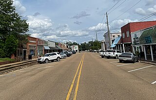
Ellisville is a town in and the first county seat of Jones County, Mississippi, United States. The population was 4,448 at the time of the 2010 census, up from 3,465 at the 2000 census. The Jones County Courthouse is located here, as is much of the county government.
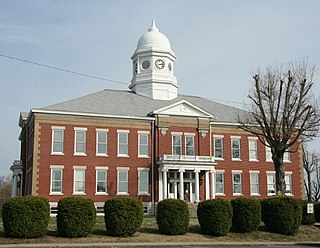
Decatur is a town in and the county seat of Newton County, Mississippi. The population was 1,841 at the 2010 census. This town is named after war hero Stephen Decatur Jr.
The Yazoo River is a river in the U.S. states of Louisiana and Mississippi. It is considered by some to mark the southern boundary of what is called the Mississippi Delta, a broad floodplain that was cultivated for cotton plantations before the American Civil War. It has continued to be devoted to large-scale agriculture.
The Mississippi River–Gulf Outlet Canal is a 76 mi (122 km) channel constructed by the United States Army Corps of Engineers at the direction of Congress in the mid-20th century that provided a shorter route between the Gulf of Mexico and New Orleans' inner harbor Industrial Canal via the Intracoastal Waterway. In 2005, the MRGO channeled Hurricane Katrina's storm surge into the heart of Greater New Orleans, contributing significantly to the subsequent multiple engineering failures experienced by the region's hurricane protection network. In the aftermath the channel was closed. A permanent storm surge barrier was constructed in the MRGO in 2009, and the channel has been closed to maritime shipping.

The Tennessee–Tombigbee Waterway is a 234-mile (377 km) artificial U.S. waterway built in the 20th century from the Tennessee River to the junction of the Black Warrior-Tombigbee River system near Demopolis, Alabama. The Tennessee–Tombigbee Waterway links commercial navigation from the nation's midsection to the Gulf of Mexico. The major features of the waterway are 234 miles (377 km) of navigation channels, a 175-foot-deep (53 m) cut between the watersheds of the Tombigbee and Tennessee rivers, and ten locks and dams. The locks are 9 by 110 by 600 feet, the same dimension as those on the Mississippi above Lock and Dam 26 at Alton, Illinois. Under construction for 12 years by the U.S. Army Corps of Engineers, the Tennessee–Tombigbee Waterway was completed in December 1984 at a total cost of nearly $2 billion.
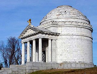
Vicksburg National Military Park preserves the site of the American Civil War Battle of Vicksburg, waged from March 29 to July 4, 1863. The park, located in Vicksburg, Mississippi, flanking the Mississippi River, also commemorates the greater Vicksburg Campaign which led up to the battle. Reconstructed forts and trenches evoke memories of the 47-day siege that ended in the surrender of the city. Victory here and at Port Hudson, farther south in Louisiana, gave the Union control of the Mississippi River.
The Florida Canal or 40 Arpent Canal is a canal in the New Orleans metropolitan area and land down river.

The Atchafalaya Basin, or Atchafalaya Swamp, is the largest wetland and swamp in the United States. Located in south central Louisiana, it is a combination of wetlands and river delta area where the Atchafalaya River and the Gulf of Mexico converge. The river stretches from near Simmesport in the north through parts of eight parishes to the Morgan City southern area.

The Honey Island Swamp is a marshland located in the eastern portion of the U.S. state of Louisiana in St. Tammany Parish. Honey Island earned its name due to the abundance of honey bees once seen on a nearby isle.
Mississippi's 3rd congressional district (MS-3) covers central portions of state and stretches from the Louisiana border in the west to the Alabama border in the east.

Horseshoe Lake is a 2,007 acres (812 ha) natural oxbow lake in Alexander County, Illinois. It is the site of Illinois's Horseshoe Lake State Fish and Wildlife Area, a state park 10,645 acres (43 km2) in size. It has a 20 miles (32 km) shoreline and a depth of 4 ft (1.2 m), with a maximum depth of 5–6 feet (1.5–1.8 m). A remnant of a large meander of the Mississippi River, it is today a shallow, isolated patch of water located near Cairo and the southern tip of Illinois. In 1972, the Horseshoe Lake Nature Preserve was designated as a National Natural Landmark by the National Park Service.
Fannegusha Creek is a stream in Carroll and Holmes counties in east-central Mississippi. It is a tributary to the Blissdale Swamp.
Kentawka Canal is a stream in the U.S. state of Mississippi.
Muskegon is an unincorporated community in Scott County, in the U.S. state of Mississippi.
Shongelo is an unincorporated community in Smith County, in the U.S. state of Mississippi.
Tippah River is a stream in the U.S. state of Mississippi. It is a tributary of the Tallahatchie River.
Yocona River is a stream in the U.S. state of Mississippi. It is a tributary of the Tallahatchie River.
References
- ↑ U.S. Geological Survey Geographic Names Information System: Lonsilocher Canal
- ↑ Baca, Keith A. (2007). Native American Place Names in Mississippi. University Press of Mississippi. p. 51. ISBN 978-1-60473-483-6.
32°41′46″N89°09′28″W / 32.6962466°N 89.1578390°W