The Tamar is a river in south west England that forms most of the border between Devon and Cornwall. A part of the Tamar Valley is a World Heritage Site due to its historic mining activities.
The Tavy is a river on Dartmoor, Devon, England. The name derives from the Brythonic root "Tam", once thought to mean 'dark' but now generally understood to mean 'to flow'. It has given its name to the town of Tavistock and the villages of Mary Tavy and Peter Tavy. It is a tributary of the River Tamar and has as its own tributaries:

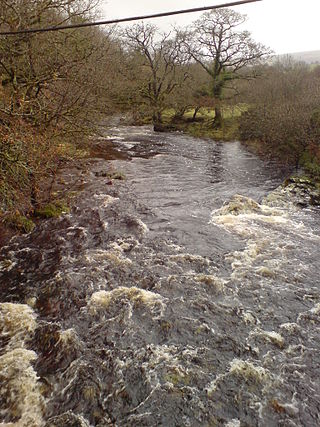
The Walkham is a river whose source is on Dartmoor, Devon, England. It rises in the wide gap between Roos Tor and Great Mis Tor and flows almost due south for approximately 3 miles (4.8 km) leaving the tors and thus National Park behind then south-west for 1 mile (1.6 km) past Woodtown. The river then reaches a village, Horrabridge, with a small compact network of streets mainly on the south or left bank. It receives most of its tributaries which are unnamed headwaters along its south-flowing inception, draining the near side of two series of six tors (peaks) to the west ending in Pew Tor at 320 metres and likewise to the east ending in Leeden Tor at 389 metres. In absolute distance, 2 miles (3.2 km) west of the village and the same south of the small well-preserved town of Tavistock by a footbridge on the West Devon Way the Walkham joins the Tavy which discharges into the Tamar Estuary north of the Plymouth conurbation after a fast descent around wide hillsides, a few miles south.
The River Yar on the Isle of Wight, England, rises near the beach at Freshwater Bay, on the south coast, and flows only a few miles north to Yarmouth where it meets the Solent. Most of the river is a tidal estuary. Its headwaters have been truncated by erosion of the south coast.

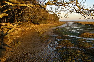
Chessel Bay is a 12.9-hectare (32-acre) Local Nature Reserve on the east bank of the River Itchen in Southampton in Hampshire. It is owned and managed by Southampton City Council. It is part of Solent and Southampton Water Ramsar site and Special Protection Area, and of Lee-on-The Solent to Itchen Estuary, which is a Site of Special Scientific Interest. It has been a local nature reserve since 1989

Morwellham Quay is an historic river port in Devon, England that developed to support the local mines. The port had its peak in the Victorian era and is now run as a tourist attraction and museum. It is the terminus of the Tavistock Canal, and has its own copper mine.
The Dawlish Warren National Nature Reserve is a national nature reserve near the village of Dawlish Warren in south Devon, England. It is part of the Exe Estuary Special Protection Area, and sits on a sand spit which runs across the mouth of the estuary. It is also a Site of Special Scientific Interest and part of it is a local nature reserve.

Week St Mary is a village and civil parish in northeast Cornwall, England, United Kingdom. It is situated south of Bude close to the River Tamar and the border between Cornwall and Devon in the Hundred of Stratton. The parish population at the 2011 census is 657.

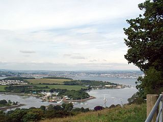
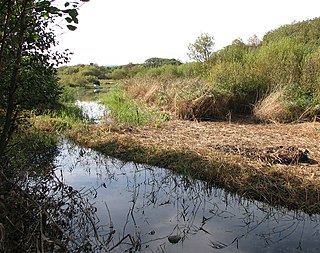
The Tamar–Tavy Estuary is a Site of Special Scientific Interest (SSSI) covering the tidal estuaries of the River Tamar and the River Tavy on the border between Cornwall and Devon in England, UK. Part of the Tamar estuary also forms the Tamar Estuary Nature Reserve, owned by the Cornwall Wildlife Trust. The site was designated in 1991 for its biodiversity and varying habitats that support many wader and wildfowl species, as well as the special interest of its marine biology.

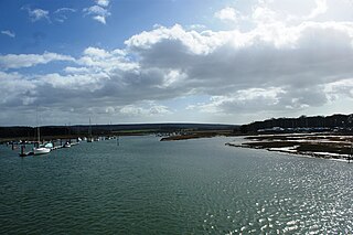
Hurst Castle and Lymington River Estuary is a 1,077.3-hectare (2,662-acre) biological and geological Site of Special Scientific Interest near Lymington in Hampshire. It is a Nature Conservation Review site and two areas are Geological Conservation Review sites. Three areas are local nature reserves, Boldre Foreshore, Sturt Pond and Lymington and Keyhaven Marshes; the latter site is managed by the Hampshire and Isle of Wight Wildlife Trust. Part of it is North Solent National Nature Reserve. It is part of Solent and Southampton Water Ramsar site and Special Protection Area. Parts of it are in Solent Maritime and Solent and Isle of Wight Lagoons Special Areas of Conservation.

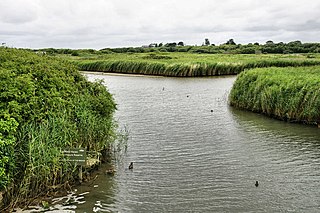
Lee-on-The Solent to Itchen Estuary is a 585.9-hectare (1,448-acre) biological and geological Site of Special Scientific Interest which stretches along the coast between Southampton and Gosport in Hampshire. It is a Geological Conservation Review site. It is part of Solent and Southampton Water Ramsar site and Special Protection Area, and of Solent Maritime Special Area of Conservation. Three areas are Local Nature Reserves, Chessel Bay, Hook with Warsash and Mercury Marshes. One area is Hamble Common Camp, a Scheduled Monument.
Titchfield Haven is a 134.5-hectare (332-acre) biological Site of Special Scientific Interest north-west of Gosport in Hampshire. Most of it is a local nature reserve and a national nature reserve. It is part of Solent and Southampton Water Ramsar site and Special Protection Area.

Upper Hamble Estuary and Woods is a 151.2-hectare (374-acre) biological Site of Special Scientific Interest east of Southampton in Hampshire. It is part of Solent and Southampton Water Ramsar site and Special Protection Area, and of Solent Maritime Special Area of Conservation. Part of the site is in Manor Farm Country Park, which is a Local Nature Reserve.
Boldre Foreshore is a 193.3-hectare (478-acre) Local Nature Reserve east of Lymington in Hampshire. It is owned by New Forest District Council and managed by the Hampshire and Isle of Wight Wildlife Trust. It is part of Solent and Southampton Water Ramsar site and Special Protection Area, Solent Maritime Special Area of Conservation, Hurst Castle and Lymington River Estuary Site of Special Scientific Interest and Lymington and Keyhaven Marshes, a nature reserve managed by the Hampshire and Isle of Wight Wildlife Trust.

Hook with Warsash is a 251.6-hectare (622-acre) Local Nature Reserve west of Fareham in Hampshire. It is owned by Hampshire County Council and managed by Hampshire Countryside Service. It is part of Solent and Southampton Water Ramsar site and Special Protection Area, of Solent Maritime Special Area of Conservation, and of Lee-on-The Solent to Itchen Estuary Site of Special Scientific Interest.

Lymington and Keyhaven Marshes is a 738-hectare (1,820-acre) nature reserve which stretches from Keyhaven along the south coast across the Lymington River in Hampshire. It is managed by the Hampshire and Isle of Wight Wildlife Trust. It is part of Solent and Southampton Water Ramsar site and Special Protection Area. Some areas are part of two Special Areas of Conservation, Solent and Isle of Wight Lagoons and Solent Maritime and Solent. It is also part of Hurst Castle and Lymington River Estuary, which is a Site of Special Scientific Interest, and of North Solent Marshes Nature Conservation Review site, Grade 2. Two areas are Geological Conservation Review sites, and two are Local Nature Reserves, Boldre Foreshore and Lymington-Keyhaven Marshes.

Mercury Marshes is a 6.4-hectare (16-acre) Local Nature Reserve in Hamble-le-Rice in Hampshire. It is owned by Hampshire County Council and managed by Hampshire Countryside Service. It is part of Solent and Southampton Water Ramsar site and Special Protection Area, of Solent Maritime Special Area of Conservation, and of Lee-on-The Solent to Itchen Estuary, which is a Site of Special Scientific Interest.

Sturt Pond is a 10.9-hectare (27-acre) Local Nature Reserve in Milford on Sea in Hampshire. It is owned and managed by Milford On Sea Parish Council. It is part of Solent and Southampton Water Ramsar site and Special Protection Area, of Solent Maritime Special Area of Conservation and of Hurst Castle and Lymington River Estuary, which is a Site of Special Scientific Interest.