
The Red River Colony, also known as Assiniboia, was a colonization project set up in 1811 by Thomas Douglas, 5th Earl of Selkirk, on 300,000 square kilometres (120,000 sq mi) of land in British North America. This land was granted to Douglas by the Hudson's Bay Company in the Selkirk Concession. It included portions of Rupert's Land, or the watershed of Hudson Bay, bounded on the north by the line of 52° N latitude roughly from the Assiniboine River east to Lake Winnipegosis. It then formed a line of 52° 30′ N latitude from Lake Winnipegosis to Lake Winnipeg, and by the Winnipeg River, Lake of the Woods and Rainy River.

Point Douglas is a provincial electoral district in Winnipeg, Manitoba, Canada. It is named for a part of the city that is surrounded by a bend in the Red River. The riding covers the neighbourhoods of William Whyte, Dufferin Industrial, North Point Douglas, Lord Selkirk Park and South Point Douglas plus parts of St. John's Park, St. John's, Inkster-Faraday, Burrows Central, Robertson, Dufferin, Logan C.P.R., Civic Centre and the Exchange District. It was also Winnipeg's only government supported red light district.

Selkirk is a provincial electoral division in the Canadian province of Manitoba. It was created by redistribution in 1957 from part of St. Andrews, and has formally existed since the provincial election of 1958. It is named after the city of Selkirk, which in turn was named for Thomas Douglas, 5th Earl of Selkirk, who set up the Red River Colony colonization project in 1811.
Pelly Crossing is a community in Yukon, Canada. It lies where the Klondike Highway crosses the Pelly River.
Provincial Trunk Highway 9 is a provincial primary highway located in the Canadian province of Manitoba. It runs from Winnipeg north to Gimli.
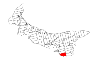
Lot 62 is a township in Queens County, Prince Edward Island, part of St. John's Parish. Lot 62 was awarded to Richard Spry, Esquire in the 1767 Land Lottery, and came to be settled through the efforts of Thomas Douglas, The 5th Earl of Selkirk in 1803. Richard Spry, Esquire, was then Commodore, Commander-in-Chief, Mediterranean Fleet at Gibraltar 1766–1769. Becoming the proprietor, he would be familiar with then the Island of St. John, having first come out to North America in 1754, with the English naval blockade of Ile Royal and the Fortress of Louisbourg in 1756, and then serving off Quebec and in the St. Lawrence into 1759. In 1762, he returned as Commander-in-Chief, North America, quartered in Halifax.

Fort Selkirk is a former trading post on the Yukon River at the confluence of the Pelly River in Canada's Yukon. For many years it was home to the Selkirk First Nation.

The Halifax Regional Municipality has a number of parks and recreation areas in urban and rural settings.

The Interlake Region is an informal geographic region of the Canadian province of Manitoba that lies roughly between Lake Winnipeg and Lake Manitoba in the Canadian province of Manitoba.
Arrow Lakes Provincial Park is a provincial park in British Columbia, Canada.

Brudenell River Provincial Park is a provincial park in Prince Edward Island, Canada. It lies on the north side of the Brudenell River. Brudenell River is the largest provincial park in eastern Prince Edward Island. Some of its land is used by Rodd Brudenell Resort. It has two public 18-hole golf courses, Brudenell River Golf Course and Dundarave Golf Course.
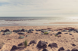
Panmure Island Provincial Park is a provincial park in Prince Edward Island, Canada. It is located along a causeway connecting Prince Edward Island with Panmure Island. The Native Council of Prince Edward Island hosts their annual Abegweit Pow Wow in the park.
Belmont Provincial Park is a provincial park in Prince Edward Island, Canada. It is located on the coast of Malpeque Bay.

Buffaloland Provincial Park is a provincial park in Prince Edward Island, Canada. It is home to a bison sanctuary.

Kings Castle Provincial Park is a provincial park in the southeastern portion of Prince Edward Island, Canada.
Pinette Park Provincial Park is a provincial park in Prince Edward Island, Canada located along the Pinette River.
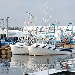
Murray Harbour is a community that holds rural municipality status in Prince Edward Island, Canada. It is located in southeastern Kings County.
Belfast is a rural municipality in Prince Edward Island, Canada. It is located in southeastern Queens County in the townships of Lot 57 and Lot 58.
Greenwich is an unincorporated Canadian rural community located in eastern Prince Edward Island, Canada.
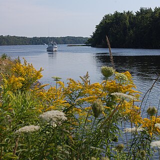
The Three Rivers are the three tidal estuaries in eastern Prince Edward Island, Canada. The water bodies are the Brudenell, Cardigan and Montague rivers, which in 2004 were included on the list of outstanding Canadian Heritage Rivers. The rivers are navigable by canoe for 52 kilometres (32 mi).