Related Research Articles
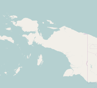
The Admiralty Islands are an archipelago group of 18 islands in the Bismarck Archipelago, to the north of New Guinea in the South Pacific Ocean. These are also sometimes called the Manus Islands, after the largest island.
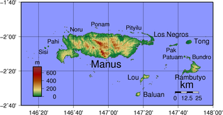
Manus Island is part of Manus Province in northern Papua New Guinea and is the largest of the Admiralty Islands. It is the fifth-largest island in Papua New Guinea, with an area of 2,100 km2 (810 sq mi), measuring around 100 km × 30 km. Manus Island is covered in rugged jungles which can be broadly described as lowland tropical rain forest. The highest point on Manus Island is Mt. Dremsel, 718 metres (2,356 ft) above sea level at the centre of the south coast. Manus Island is volcanic in origin and probably broke through the ocean's surface in the late Miocene, 8 to 10 million years ago. The substrate of the island is either directly volcanic or from uplifted coral limestone.

Seeadler Harbor, also known as Port Seeadler, is located on Manus Island, Admiralty Islands, Papua New Guinea and played an important role in World War II. In German, "Seeadler" means sea eagle, pointing to German colonial activity between 1884 and 1919 in that area. The bay was named in 1900 after the German cruiser SMS Seeadler.

Emirau Island, also called Emira, is an island in the Bismarck Archipelago located at 1°38.5′S149°58.5′E. It is currently part of the New Ireland Province of Papua New Guinea. The local language is a dialect of the Mussau-Emira language. Emira is part of what on many maps are charted as the St Matthias Islands, also known as the Mussau Islands, a small group to the north-west of the main-island group of New Ireland. Early explorers named it Squally Island, a name still found in some early records.

Lorengau is the major town in Manus Province, Papua New Guinea. The town is located on the edge of Seeadler Harbour on Manus Island, in the Admiralty Islands, and in 2000 Lorengau was recorded to have a population of 5,829.

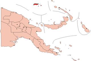
Manus Province is the smallest province in Papua New Guinea with a land area of 2,100 km², but with more than 220,000 km² of water. The provincial town of Manus is Lorengau and the total population is 60,485.
RAF Little Rissington is an RAF aerodrome and RAF station in Gloucestershire, England. It was once home to the Central Flying School, the Vintage Pair and the Red Arrows.
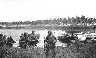
The Admiralty Islands campaign was a series of battles in the New Guinea campaign of World War II in which the United States Army's 1st Cavalry Division took the Japanese-held Admiralty Islands.
Frans Kaisiepo International Airport, is an airport in Biak, Papua, Indonesia. It is also known as Mokmer Airport. The airport is named after Frans Kaisiepo, the fourth Governor of Papua. The airport has seven aircraft parking slots, of which two are capable of handling wide-body aircraft, and a small terminal without jet bridges. The airport's only runway is 3,571m long, designated as 11/29.

Sentani International Airport is an airport serving Jayapura, the capital of Papua province, Indonesia, on the island of New Guinea. It is located in the town of Sentani District, approximately 40 km from downtown Jayapura; the name 'Sentani' is taken from a Lake Sentani nearby. It is the easternmost airport in Indonesia, the largest airport in Papua and the main hub to outside the island of Papua, Since 14 October 2019 the management of the airport is taken over by PT Angkasa Pura I (Persero).
Losuia Airport is an airport in Losuia, on the island of Kiriwina, Papua New Guinea.

Momote Airport is an airport on Los Negros Island in the Admiralty Islands, Papua New Guinea. It also serves Manus Island, which is connected to Los Negros by a bridge.
Munda Airport is an international airport adjacent to the town of Munda, Western Province in Solomon Islands.

Los Negros Island is the third largest of the Admiralty Islands. It is significant because it contains the main airport of Manus Province on its eastern coastline, at Momote. It is connected to Lorengau, the capital of the province, on Manus Island via a highway and bridge across the Lonui Passage, which separates Los Negros from the larger Manus Island.
Pityilu Island is part of Manus Province in northern Papua New Guinea and part of the Admiralty Islands. It is off the northern coast of Manus Island and is nearly 4.8 km long and varies in width from 76 to 198 metres.
Mokerang Airfield, was an airfield on the northwest tip of Los Negros Island, 5 miles (8.0 km) NNW of Momote Airfield.

Peleliu Airfield is a small airfield on Peleliu, one of the islands of Palau. It also served as an airfield during World War II.

Central Field or Iwo Jima Air Base is a World War II airfield on Iwo Jima in the Bonin Islands, located in the Central Pacific. The Bonin Islands are part of Japan.
North Field is a former World War II airfield on Tinian in the Mariana Islands. Abandoned after the war, today North Field is a tourist attraction. Along with several adjacent beaches on which Allied forces landed during the Battle of Tinian, the airfield is the major component of the National Historic Landmark District Tinian Landing Beaches, Ushi Point Field, Tinian Island.
The Port Moresby Airfield Complex was a World War II military airfield complex, built near Port Moresby, Papua and New Guinea. It was used during the Battle of New Guinea as a base of Allied air operations primarily in 1942 and early 1943. It later became a support base as the battle moved to the north and western part of New Guinea. It was closed and the facility turned over to civil authorities after the end of the war in September 1945.
References
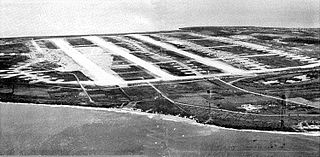
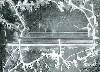
- ↑ Lorengau Airfield and Vicinity, image, USAAF, 5th AF, 22 January 1944, www.pacificwrecks.org, accessed 23 July 2013
Coordinates: 2°01′13″S147°16′00″E / 2.02028°S 147.26667°E
| This article about an Oceanian airport is a stub. You can help Wikipedia by expanding it. |
| This article about a Papua New Guinean building or structure related topic is a stub. You can help Wikipedia by expanding it. |