
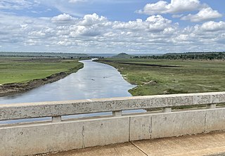
Sierra Leone is a country in West Africa with a North Atlantic Ocean coastline to the west. It lies on the African Plate. The country's main geographical features include wooded hill country, an upland plateau, and mountains in the east. The highest peak is Mount Bintumani, which is 1,948 meters (6,391 ft) above sea level. The coastline has a belt of mangrove swamps. Freetown, the nation's capital city, has one of the world's largest natural harbours. The Rokel River is the largest river in Sierra Leone. It is 400 kilometres (250 mi) long and has a basin with a total area of 10,622 square kilometres (4,101 sq mi).
The Qattara Depression is a depression in northwestern Egypt, specifically in the Matruh Governorate. The depression is part of the Western Desert of Egypt. The Qattara Depression lies below sea level, and its bottom is covered with salt pans, sand dunes, and salt marshes. The depression extends between the latitudes of 28°35' and 30°25' north and the longitudes of 26°20' and 29°02' east.

Lake Naivasha is a freshwater lake in Kenya, outside the town of Naivasha in Nakuru County, which lies north west of Nairobi. It is situated in the Great Rift Valley. The name derives from the local Maasai name ɛnaɨpɔ́sha , meaning "that which heaves," a common Maasai word for bodies of water large enough to have wave action when it is windy or stormy. Naivasha arose from a British attempt to pronounce the Maasai name. Literally, Lake Naivasha means "Lake Lake."

The Luapula River is a north-flowing river of central Africa, within the Congo River watershed. It rises in the wetlands of Lake Bangweulu (Zambia), which are fed by the Chambeshi River. The Luapula flows west then north, marking the border between Zambia and the Democratic Republic of the Congo before emptying into Lake Mweru. The river gives its name to Zambia's Luapula Province.

Samburu National Reserve is a game reserve on the banks of the Ewaso Ng'iro river in Kenya. It is 165 km2 (64 sq mi) in size and is 350 km (220 mi) from Nairobi. It ranges in elevation from 800 to 1,230 m. Geographically and administratively, it is part of Samburu County.

Chott Melrhir, also known as Chott Melghir or Chott Melhir, is an endorheic chott-kind of salt lake in northeastern Algeria. It is the westernmost part of a series of depressions which extend from the Gulf of Gabès into the Sahara. It was formerly known as Lake Tritonis. They were created between Miocene and Early Pleistocene as a result of compression accompanying the formation of the Atlas Mountains. With the maximum area of about 6,700 km2 (2,600 sq mi), it is the largest lake in Algeria. It lies almost entirely below sea level and contains the lowest point in Algeria, −40 meters. Its size varies over the year and is usually larger than 130 km (81 mi) from east to west. The nearby cities are Biskra, El Oued and Touggourt.

The Ngounié River is a river flowing through southwest-central Gabon. It is the last and second most important tributary of the Ogooué River, the first being the Ivindo River. It initially flows down from the Chaillu Mountains, along the border with Congo, and then turns northwest, flowing through the towns of Fougamou, Sindara and Mouila before flowing into the Ogooué.

Ewaso Ng'iro, also called Ewaso Nyiro, is a river in Kenya which rises on the west side of Mount Kenya and flows north, then east and finally south-east, passing through Somalia where it joins the Jubba River. The river's name is derived from the local community's language, and means river of brown or muddy water. Downstream, the intermittent stream in Somalia is also called Lagh Dera.
The Malagarasi River is a river in western Tanzania, flowing through Kigoma Region, although one of its tributaries comes from southeastern Burundi. The river also forms the western border of Tabora Region, the southern border of Kagera Region and the southwestern border of Geita Region. It is the second-longest river in Tanzania behind the Rufiji—Great Ruaha, and has the largest watershed of any river flowing into Lake Tanganyika. The Malagarasi-Muyovozi Wetlands are a designated a Ramsar site. Local tribes have nicknamed the Malagarasi as "the river of bad spirits".
The Arafura Swamp is a large inland freshwater wetland in Arnhem Land, in the Top End of the Northern Territory of Australia. It is a near pristine floodplain with an area of 700 square kilometres (270 sq mi) that may expand to 1,300 km2 (500 sq mi) by the end of the wet season, making it the largest wooded swamp in the Northern Territory and, possibly, in Australia. It has a strong seasonal variation in depth of water. The area is of great cultural significance to the Yolngu people, in particular the Ramingining community. It was the filming location for the film Ten Canoes.
Zemongo Faunal Reserve is a protected reserve of the Central African Republic. Established in 1925, it was extended and redesignated in 1975, although still open to hunting in 1980. The main rivers are the Vovado River and the Goangoa River, covering an area of 10,100 square kilometres (3,900 sq mi), of which 1,720 square kilometres (660 sq mi) is inundated forest. The reserve contains dense Isoberlinia savanna woodland and gallery forests and supports eastern chimpanzees and other primate species. The reserve formerly held a large elephant population and a diverse antelope community.

Tanzania contains some 20 percent of the species of Africa's large mammal population, found across its reserves, conservation areas, marine parks, and 17 national parks, spread over an area of more than 42,000 square kilometres (16,000 sq mi) and forming approximately 38 percent of the country's territory. Wildlife resources of Tanzania are described as "without parallel in Africa" and "the prime game viewing country". Serengeti National Park, the country's second largest national park area at 14,763 square kilometres (5,700 sq mi), is located in northern Tanzania and is famous for its extensive migratory herds of wildebeests and zebra while also having the reputation as one of the great natural wonders of the world. The Ngorongoro Conservation Area, established in 1959, is a UNESCO World Heritage Site and inhabited by the Maasai people. Its Ngorongoro Crater is the largest intact caldera in the world.

Buffalo Springs National Reserve is a protected area in Isiolo County, Kenya.
The Waseges River, or Sandai River, is a river in Kenya. Its source is on the slopes of the Nyandarua Plateau below the Aberdare Range; it ends its course in lake Bogoria.

The Southern Ewaso Ng'iro is a river in the Great Rift Valley in Kenya. It plays an important role in the ecology of Lake Natron, the main regular breeding site for near-threatened lesser flamingos. Changes to land use in the river's headwaters or in the marshes before the river enters the lake could have a serious impact on this species.
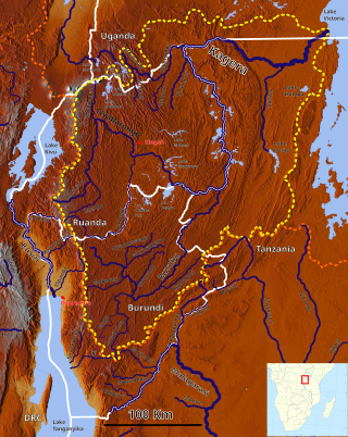
The Akanyaru River is the main tributary of the Nyabarongo River. It rises in the western highlands of Rwanda and Burundi, flows east and then north along the border between those countries before joining the Nyabarongo River. The lower stretches contain important but unprotected wetlands, which are under threat from human activity.
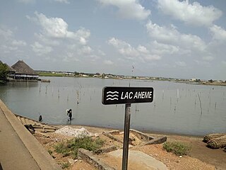
Lake Ahémé is Benin's second largest lake, with an area of 78 square kilometres (30 sq mi) in the dry season which expands to 100 square kilometres (39 sq mi) in the rainy season. The lake is 24 kilometres (15 mi) long and has an average width of 3.6 kilometres (2.2 mi). The Couffo River drains into the swampy north end of the lake, while the 10 km-long Aho Channel connects the lake's southern end to the Grand-Popo Lagoon on the Atlantic coast. This channel flows south during the wet season but reverses direction in the dry season, which causes the salinity of the lake's southern end to increase.
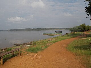
The Aby Lagoon complex is the second largest lagoon in Ivory Coast, after Ébrié Lagoon. As a whole, the lagoon has an area of 424 km2 (164 sq mi), a mean depth of 3.5 m (11 ft), and a volume of 1.57 km3 (0.38 cu mi). It drains into the Atlantic Ocean through shallow channels between the Ehotilé Islands that converge at Assinie-Mafia, where Assoindé Lagoon also connects from the west. Assoindé Lagoon connects the Aby Lagoon complex to Ébrié Lagoon through the Assinie Canal.
Penola Conservation Park is a protected area located in the Australian state of South Australia in the locality of Monbulla about 329 kilometres (204 mi) south-east of the state capital of Adelaide and about 12 kilometres (7.5 mi) west of the town of Penola.
Lake Sare is a lake in western Kenya that lies between the Yala Swamp and Lake Victoria. It has potential as a site for restocking fish species that have become endangered in Lake Victoria, but due to lack of management the lake ecology is steadily degrading.
