
Newcastle upon Tyne, often simply Newcastle, is the most populous city and metropolitan borough in North East England. It forms the core of the Tyneside conurbation, the eighth most populous urban area in the United Kingdom. The city is situated on the River Tyne's northern bank, approximately 8.5 mi (13.7 km) from the North Sea.
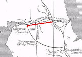
The Stanegate was an important Roman road built in what is now northern England. It linked two forts that guarded important river crossings: Corstopitum (Corbridge) on the River Tyne in the east, and situated on Dere Street, and Luguvalium (Carlisle) on the River Eden in the west. The Stanegate ran through the natural gap formed by the valleys of the River Tyne in Northumberland and the River Irthing in Cumbria. It predated Hadrian's Wall by several decades; the Wall would later follow a similar route, slightly to the north.

Wallsend, historically Wallsend on Tyne, is a town in the metropolitan borough of North Tyneside in the metropolitan county of Tyne and Wear, North East England. Historically, Wallsend is in the county of Northumberland. Wallsend derives its name from its location at the eastern end of Hadrian's Wall. It has a population of 43,842 and lies 3.5 miles east of Newcastle upon Tyne.

Chester-le-Street, also known as Chester, is a market town and civil parish north of the River Wear, England. It is in the district, lieutenancy and historic palatine of Durham. The town's history is ancient, records go back to a Roman-built fort called Concangis.

The A69 is a major northern trunk road in England, running east–west across the Pennines, through the counties of Tyne and Wear, Northumberland and Cumbria. Originally, the road started in the centre of Newcastle upon Tyne then later near Birtley, but since the creation of the A1 Western Bypass around Newcastle upon Tyne, it now starts at Denton Burn, a suburb of Newcastle upon Tyne.

Haltwhistle is a market town and civil parish in Northumberland, England, 10 miles (16 km) east of Brampton. It had a population of 3,811 at the 2011 Census.

Blaydon is a town in the Metropolitan Borough of Gateshead, Tyne and Wear, England, and historically in County Durham. Blaydon, and neighbouring Winlaton, which Blaydon is now contiguous with, form the postal town of Blaydon-on-Tyne. The Blaydon/Winlaton resident population in 2011 was 13,896.

Waldridge is a village in County Durham, in England. The population at the 2001 Census was 215. Prior to the 2011 Census the parish boundaries changed and the population shown at this census was 4,215. It is situated to the south west of Chester-le-Street. It is known as either Waldridge Fell or Waldridge Village, the 'Fell' referring to the surrounding area of moorland. The village used to be known as Waldridge Colliery. The current village dates back to the 1890s, the original village having been located on the fell which overlooks the present location. Rainwater runs into the Cong Burn to the north and the South Burn to the south, both of which flow into the River Wear which is a few miles to the east.

Whitburn is a village in South Tyneside, on the coast of North East England. It lies within the metropolitan borough of South Tyneside, roughly halfway between South Shields and Sunderland, in the metropolitan county of Tyne and Wear. Historically, the village was a part of County Durham. According to the 2001 census, the village has a population of 5,235.

The history of Newcastle upon Tyne dates back almost 2,000 years, during which it has been controlled by the Romans, the Angles and the Norsemen amongst others. Originally known by its Roman name Pons Aelius, the name "Newcastle" has been used since the Norman conquest of England. Due to its prime location on the River Tyne, the town developed greatly during the Middle Ages and it was to play a major role in the Industrial Revolution, being granted city status in 1882. Today, the city is a major retail, commercial and cultural centre.

Ryton is a town in the Metropolitan Borough of Gateshead, Tyne and Wear, England, 5.8 miles (9.3 km) west of Newcastle upon Tyne. Historically in County Durham, it was incorporated into the metropolitan county of Tyne and Wear and the Borough of Gateshead in 1974. In 2011, the population of the Ryton, Crookhill and Stella ward was 8,146.
Ormiston is a village in East Lothian, Scotland, near Tranent, Humbie, Pencaitland and Cranston, located on the north bank of the River Tyne at an elevation of about 276 feet (84 m).

Newburn is a semi rural parish, former electoral ward and former urban district in western Newcastle upon Tyne, North East England. Situated on the North bank of the River Tyne, it is built rising up the valley from the river. It is situated approximately 5 miles (8.0 km) from the city centre, 14 miles (23 km) east of Hexham and 13 miles (21 km) south south west of Morpeth. In the 2001 census, the population was given as 9,301, increasing to 9,536 at the 2011 Census. Newburn is in the Newcastle upon Tyne district of Tyne and Wear and is part of the parliamentary constituency of Newcastle upon Tyne North.

Byker is a district in the east of the city and metropolitan borough of Newcastle upon Tyne. Home to the Byker Wall estate, made famous by TV series Byker Grove, Byker’s population was recorded at 12,206 in the 2011 census. Byker is bordered by Heaton to the north and by Shieldfield to the north east.

The River Team is a tributary of the River Tyne in Gateshead, England.

The Rede is a river in Northumberland, England. The river rises on Carter Fell on the Anglo-Scottish border feeding Catcleugh Reservoir and joins the River North Tyne below the village of Redesmouth. The Rede is one of only two rivers in the North East of England that has the freshwater pearl mussel in its waters.
Vindomora was an auxiliary fort on Dere Street, in the province of Lower Britain. Its ruins, now known as Ebchester Roman Fort, are situated at Ebchester in the English county of Durham, to the north of Consett and 12 miles (19 km) west-south-west from Newcastle upon Tyne.
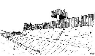
Concangis was an auxiliary castra in the Roman province of Lower Britain. Its ruins are located in Chester-le-Street, Durham, in England, and are now known as Chester-le-Street Roman Fort. It is situated 6 miles (10 km) north of Durham and 8 miles (13 km) south of Newcastle upon Tyne.

Newcastle City Centre is the city centre district of Newcastle upon Tyne, England. It is the historical heart of the city and serves as the main cultural and commercial centre of the North East England region. Along with nearby Gateshead town centre, which lies on the opposite side of the River Tyne, the city centre forms the core of the Tyneside conurbation.

Seaton Burn is a village in Tyne and Wear, England to the north of Newcastle upon Tyne, and adjacent to Wideopen which is just south of it. The A1 used to pass through the village but now bypasses the village just to the west, where it meets the A19 which is the link road to the Tyne Tunnel.