Related Research Articles

Clifton is an incorporated town located in southwestern Fairfax County, Virginia, United States, with a population of 243 at the time of the 2020 census.

Lorton is a census-designated place (CDP) in Fairfax County, Virginia, United States. The population was 20,072 as of the 2020 census.

Woodbridge is a census-designated place (CDP) in Prince William County, Virginia, United States, located 20 miles (32 km) south of Washington, D.C. Bounded by the Occoquan and Potomac rivers, Woodbridge had 44,668 residents at the 2020 census.

The Washington and Old Dominion Railroad was an intrastate short-line railroad located in Northern Virginia, United States. The railroad was a successor to the bankrupt Washington and Old Dominion Railway and to several earlier railroads, the first of which began operating in 1859. The railroad closed in 1968.
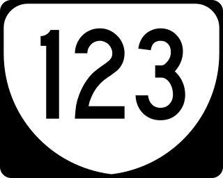
State Route 123 or Virginia State Route 123 is a primary state highway in the U.S. state of Virginia. The state highway runs 29.27 miles (47.11 km) from U.S. Route 1 in Woodbridge north to the Chain Bridge across the Potomac River into Washington from Arlington. It goes by five local names. From its southern terminus to the Occoquan River Bridge, it is known as Gordon Boulevard. From the Occoquan River Bridge to the city of Fairfax it is known as Ox Road. From Fairfax until it enters the Town of Vienna, it is known as Chain Bridge Road. Then, as it passes through the Town of Vienna, it is known as Maple Avenue. After leaving the Town of Vienna, the name reverts to Chain Bridge Road, and continues this way until the intersection with I-495 in Tysons. Between Tysons and the George Washington Memorial Parkway, it is known as Dolley Madison Boulevard. After crossing over the George Washington Memorial Parkway, the name once again reverts to Chain Bridge Road and continues this way until the end of the road, at Chain Bridge. SR 123 is a partial circumferential highway in Northern Virginia that connects Woodbridge in eastern Prince William County with the independent city of Fairfax and the Fairfax County communities of Vienna, Tysons, and McLean, the last being the home of the National Counterterrorism Center and the Central Intelligence Agency. The state highway also connects all of the major highways that radiate from Washington, including Interstate 95 (I-95), I-66, US 29, US 50, SR 267, and the George Washington Memorial Parkway. Furthermore, SR 123 crosses another pair of circumferential highways, I-495 and the Fairfax County Parkway, and SR 7, a major northwest–southeast highway through Northern Virginia. The state highway is a part of the National Highway System for its entire length.
NOVA Parks is an inter-jurisdictional organization that owns and operates more than 10,000 acres of woodlands, streams, parks, trails, nature reserves, countryside and historic sites in Northern Virginia in the United States. The Authority was organized in 1959. NOVA Parks presently operates 34 regional parks.
L&O may refer to:

The Lorton Reformatory, also known as the Lorton Correctional Complex, is a former prison complex in Lorton, Virginia, established in 1910 for the District of Columbia, United States.

Pohick Creek is a 14.0-mile-long (22.5 km) tributary stream of the Potomac River in Fairfax County in the U.S. state of Virginia. It takes its name from the Pohick Native American tribe once prevalent in the area.

State Route 242 is a primary state highway in the U.S. state of Virginia. Known as Gunston Road, the state highway runs 3.58 miles (5.76 km) from U.S. Route 1 near Lorton east to SR 600 at the entrance to Gunston Hall, the plantation of George Mason, on Mason Neck in southeastern Fairfax County.
The Manassas Gap Railroad (MGRR) ran from Mount Jackson, Virginia, to the Orange and Alexandria Railroad's Manassas Junction, which later became the city of Manassas, Virginia. Chartered by the Virginia General Assembly in 1850, the MGRR was a 4 ft 8 in narrow gauge line whose 90 completed miles of track included 38 miles (61 km) of 60 pounds-per-yard T-rail and 52 miles (84 km) of 52 pounds-per-yard T-rail. A total of nine locomotives and 232 cars were operated on the line, serving 20 stations.

The Centreville Military Railroad was a 5.5-mile (8.9 km) spur running from the Orange and Alexandria Railroad east of Manassas Junction across Bull Run and up the south side of the Centreville Plateau. Built by the Confederate States Army between November 1861 and February 1862, it was the first exclusively military railroad. Ultimately, the Centreville Military Railroad reached a point near a modern McDonald's restaurant on Virginia State Route 28, south of the modern junction with U.S. Route 29 in Virginia.
The District of Columbia Department of Corrections (DCDC) is a law enforcement agency responsible for the adult jails and other adult correctional institutions and law enforcement buildings for the District of Columbia, in the United States. DCDC runs the D.C. Jail.

State Route 611 in Fairfax County, Virginia is a secondary state highway which traverses the eastern portion of the county. SR 611 provides a major artery for commuters, connecting the Eisenhower Valley section of Alexandria with Lorton and points south along US 1. SR 611 is known by three names: Telegraph Road, Old Colchester Road, and Furnace Road.

The Workhouse Arts Center in Lorton, Virginia is a 55-acre center for the arts and arts education that, through adaptive reuse, utilizes existing structures on repurposed land in the former Lorton Reformatory. A strong community partner with a growing national reputation, the Workhouse hosts celebrations, offers space for special events, and showcases Fairfax County's commitment to the arts. The Workhouse is a 501(c)3 non-profit organization and relies on the generosity of WAC partners and community.

The Occoquan River is a tributary of the Potomac River in Northern Virginia, where it serves as part of the boundary between Fairfax and Prince William counties. The river is a scenic area, and several local high schools and colleges use the river for the sport of rowing.

Crosspointe is a census-designated place in Fairfax County, Virginia, United States. The population as of the 2020 census was 5,722.
Laurel Hill is a census-designated place in Fairfax County, Virginia, United States. The population at the 2020 census was 8,307. Formerly part of the Lorton CDP, it comprises most of what was formerly the Lorton Reformatory grounds, which were purchased by Fairfax County in 2002 following the prison's closing and redeveloped as a new suburban community. The name "Laurel Hill" was adopted from Laurel Hill House, an 18th-century structure which had served as the residence of the Superintendent of the Reformatory, and originally was the home of Revolutionary War patriot William Lindsay.

Occoquan Regional Park is a regional park along a tributary of the Potomac River, located in Lorton in Fairfax County in Northern Virginia, USA.

The Gerry Connolly Cross County Trail is a 40.5-mile hiking, biking and bridle trail in Fairfax County, Virginia that traverses the entire length of the county in an arc that begins and ends at different points near the Potomac River. The northern portion of the trail follows Difficult Run, while the southern half largely follows Accotink Creek and Pohick Creek.
References
- ↑ "The Lorton and Occoquan Railroad" . Retrieved 24 September 2018.
- ↑ "Cross County Trail Opens". The Washington Post. 17 December 2005. Retrieved 19 December 2024.
- ↑ Rein, Lisa (12 July 2006). "Along a Scenic Trail, a Crumbling Jail". The Washington Post. Retrieved 24 September 2018.
- ↑ "Laurel Hill: From Prison to Park" . Retrieved 27 December 2024.