Lorum High Cross

Last updated
Lorum High Cross
Native name
Irish: Ardchros Leamhdhroma

Lorum High Cross 2017 09 12.jpg

Surviving granite shaft of the cross
Location Lorum, Ballinkillin,
County Carlow, Ireland
Coordinates 52°39′51″N6°55′56″W / 52.664028°N 6.932335°W / 52.664028; -6.932335 Coordinates: 52°39′51″N6°55′56″W / 52.664028°N 6.932335°W / 52.664028; -6.932335
Ireland adm location map.svg
Red pog.svg
Location of Lorum High Cross in Ireland

Lorum High Cross is a high cross fragment and National Monument located in Lorum, County Carlow, Ireland [1] [2] The cross belongs to an early monastic site which is associated with Molaise of Leighlin. [3] The remaining cross fragment consists of a granite shaft with a height of 55 cm and a width of 30 cm that resides on a small cairn with a diameter of 210 cm. [2]

High cross free-standing Christian cross made of stone and often richly decorated

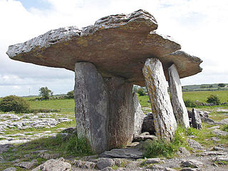
A high cross or standing cross is a free-standing Christian cross made of stone and often richly decorated. There was a unique Early Medieval tradition in Ireland and Britain of raising large sculpted stone crosses, usually outdoors. These probably developed from earlier traditions using wood, perhaps with metalwork attachments, and earlier pagan Celtic memorial stones; the Pictish stones of Scotland may also have influenced the form. The earliest surviving examples seem to come from the territory of the Anglo-Saxon kingdom of Northumbria, which had been converted to Christianity by Irish missionaries; it remains unclear whether the form first developed in Ireland or Britain.

County Carlow County in the Republic of Ireland

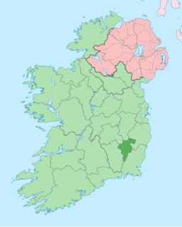
County Carlow is a county in Ireland, part of the South-East Region and the province of Leinster. It is named after the town of Carlow, which lies on the River Barrow. Carlow County Council is the local authority. The population was 56,932 at the 2016 census.

Republic of Ireland Ireland, a country in north-western Europe, occupying 5/6 of the island of Ireland; succeeded the Irish Free State (1937)

Ireland, also known as the Republic of Ireland, is a country in north-western Europe occupying 26 of 32 counties of the island of Ireland. The capital and largest city is Dublin, which is located on the eastern part of the island, and whose metropolitan area is home to around a third of the country's over 4.8 million inhabitants. The sovereign state shares its only land border with Northern Ireland, a part of the United Kingdom. It is otherwise surrounded by the Atlantic Ocean, with the Celtic Sea to the south, St George's Channel to the south-east, and the Irish Sea to the east. It is a unitary, parliamentary republic. The legislature, the Oireachtas, consists of a lower house, Dáil Éireann, an upper house, Seanad Éireann, and an elected President who serves as the largely ceremonial head of state, but with some important powers and duties. The head of government is the Taoiseach, who is elected by the Dáil and appointed by the President; the Taoiseach in turn appoints other government ministers.

Related Research Articles

N81 road (Ireland) road in Ireland

The N81 road is a national secondary road in Ireland, from the M50 motorway to Tullow, County Carlow, north to south. The N81 continues past Tullow for another 8 km to terminate at the village of Closh, County Carlow, where it intersects the N80. The N81 is 76.784 km (47.711 mi) long. The road is a dual carriageway between M50 motorway and west of Tallaght, known as the Tallaght Bypass or Blessington Road. It intersects with the M50 motorway at Junction 11. There are plans to extend the dual carriageway by 5 km (3.1 mi) to the urban boundary.

Nurney, County Carlow Town in Leinster, Ireland

Nurney is a village in County Carlow, Ireland.

Moone

Moone is a small village in the south of County Kildare, Ireland. It is on the former N9 road about 80 km (50 mi) south of Dublin. It has only a few hundred inhabitants, a church, a National School, one shop and a small community centre. There is also pub called the Moone High Cross Inn.

Poulnabrone dolmen Dolmen (burial chamber) in Ireland

Poulnabrone dolmen is an unusually large dolmen or portal tomb located in the Burren, County Clare, Ireland. Situated on one of the most desolate and highest points of the region, it comprises three standing portal stones supporting a horizontal capstone, and dates to the Neolithic period, probably between 4200 BC and 2900 BC. It the best known and most widely photographed of the approximately 172 dolmens in Ireland.

Ballinkillin Village in Leinster, Ireland

Ballinkillin or Ballinkillen is a small village between Borris and Muine Bheag in County Carlow, Ireland. The village itself has 20 homes and about 74 people. It includes a national school, a local shop, a hurling pitch and two housing estates, one of which is a new housing estate called "Schoolhouse Gate".

R747 road (Ireland) road

The R747 road is a regional road in Ireland running north-west/south-east from the M9 near Ballitore in County Kildare to Arklow in County Wicklow, a distance of 66 km (41 mi).

Carlow Town in Leinster, Ireland

Carlow is the county town of County Carlow, in the south-east of Ireland, 84 km (52 mi) from Dublin. At the 2016 census, it had a combined urban and rural population of 24,272.

Events from the year 1873 in Ireland.

Brownshill dolmen dolmen in County Carlow, Ireland

Brownshill Dolmen is a very large megalithic portal tomb situated 3 km east of Carlow, in County Carlow, Ireland. It's capstone weighs an estimated 100 metric tons, and is reputed to be the heaviest in Europe. The tomb is listed as a National Monument. Known as the Kernanstown Cromlech, sometimes spelled as Browneshill Dolmen, it is sited on the former estate house of the Browne family from which it takes its name.

R417 road (Ireland)

The R417 road is a regional road in Ireland, which runs north-south from the R445 in Monasterevin, County Kildare to the R448 in Carlow, County Carlow.

Tinryland Town in Leinster, Ireland

Tinryland is a village in County Carlow, Ireland, less than 5 km south of Carlow town. It is within the townland of Tinriland, in the parish of Tullowmagimma.

Carlow Castle 13th-century castle in County Carlow, Ireland

Carlow Castle is located near to the River Barrow in County Carlow, Ireland. It was built between 1207 and 1213, and is a National Monument of Ireland.

Ballymoon Castle

Ballymoon Castle is a National Monument situated 2 miles (3 km) east of Muine Bheag (Bagenalstown), County Carlow, Ireland. The castle is thought to date from the 13th century.

R448 road (Ireland)

The R448 road is a regional road in Ireland. It is the designation given to the former N9 national primary road when it was bypassed by the M9 motorway.

National monument (Ireland) monument assigned national importance in Ireland

A National Monument in the Republic of Ireland is a structure or site, the preservation of which has been deemed to be of national importance and therefore worthy of state protection. If the land adjoining the monument is essential to protect it, this land may also be protected.

Ullard Church Church in County Kilkenny, Ireland

Ullard Church is a medieval church and National Monument in County Kilkenny, Ireland.

The Record of Monuments and Places is a list of historical and archaeological sites the Republic of Ireland established under the National Monuments Acts.

Lorum may refer to:

References

  1. "National Monuments in State Care: Ownership & Guardianship – Carlow" (PDF). National Monuments Service. 2009-03-04.
  2. 1 2 Brindley, Anna; Kilfeather, Annaba (1993). Archaeological Survey of County Carlow. Dublin: Stationery Office. pp. 58, 61. ISBN   0-7076-0324-2.
  3. Gwynn, Aubrey; R. Neville, Hadcock (1970). Medieval Religious Houses Ireland. London: Longman. p. 397.