Los Molinos Dam

Last updated
Los Molinos Dam

LosMolinosDamLower.jpg

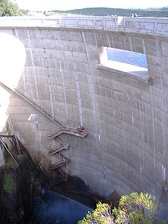
Downstream face of the dam
Relief Map of Argentina.jpg
Red pog.svg
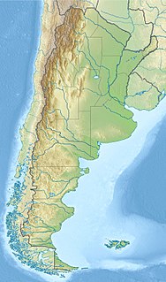
Location of Los Molinos Dam in Argentina
Country Argentina
Location Córdoba
Coordinates 31°49′6.16″S64°30′10.78″W / 31.8183778°S 64.5029944°W / -31.8183778; -64.5029944 Coordinates: 31°49′6.16″S64°30′10.78″W / 31.8183778°S 64.5029944°W / -31.8183778; -64.5029944
Purpose Power, water supply, flood control
Status Operational
Construction began 1948
Opening date 1953;65 years ago (1953)
Owner(s) Empresa Provincial de Energia de Cordoba (EPEC)
Dam and spillways
Type of dam Arch
Impounds Los Molinos River
Height 60 m (200 ft)
Length 240 m (790 ft)
Reservoir
Total capacity 399×10^6 m3 (323,000 acre⋅ft)
Catchment area 980 km2 (380 sq mi)
Surface area 24.5 km2 (9.5 sq mi)
Los Molinos I
Coordinates 31°50′17.40″S64°26′46.81″W / 31.8381667°S 64.4463361°W / -31.8381667; -64.4463361
Commission date 1956
Turbines 4 x 13 MW (17,000 hp) Francis-type
Installed capacity 52 MW (70,000 hp) [1]

The Los Molinos Dam (in Spanish, Dique Los Molinos) is a dam over the course of the Los Molinos River in the center-west of the province of Córdoba, Argentina, about 769 metres (2,523 ft) above mean sea level.

Dam A barrier that stops or restricts the flow of surface or underground streams

A dam is a barrier that stops or restricts the flow of water or underground streams. Reservoirs created by dams not only suppress floods but also provide water for activities such as irrigation, human consumption, industrial use, aquaculture, and navigability. Hydropower is often used in conjunction with dams to generate electricity. A dam can also be used to collect water or for storage of water which can be evenly distributed between locations. Dams generally serve the primary purpose of retaining water, while other structures such as floodgates or levees are used to manage or prevent water flow into specific land regions. The earliest known dam is the Jawa Dam in Jordan, dating to 3,000 BC.

Provinces of Argentina

Argentina is subdivided into twenty-three provinces and one autonomous city, Buenos Aires, which is the federal capital of the nation as decided by Congress. The provinces and the capital have their own constitutions, but exist under a federal system.

Argentina federal republic in South America

Argentina, officially the Argentine Republic, is a country located mostly in the southern half of South America. Sharing the bulk of the Southern Cone with Chile to the west, the country is also bordered by Bolivia and Paraguay to the north, Brazil to the northeast, Uruguay and the South Atlantic Ocean to the east, and the Drake Passage to the south. With a mainland area of 2,780,400 km2 (1,073,500 sq mi), Argentina is the eighth-largest country in the world, the fourth largest in the Americas, and the largest Spanish-speaking nation. The sovereign state is subdivided into twenty-three provinces and one autonomous city, Buenos Aires, which is the federal capital of the nation as decided by Congress. The provinces and the capital have their own constitutions, but exist under a federal system. Argentina claims sovereignty over part of Antarctica, the Falkland Islands, and South Georgia and the South Sandwich Islands.

Contents

The dam gathers the flow of a 980 square kilometres (380 sq mi) catchment basin. Its wall is 60 metres (200 ft) high and 240 metres (790 ft)long. The reservoir has a surface area of 24.5 square kilometres (9.5 sq mi) and a volume of 399 million cubic metres (323,000 acre⋅ft); the maximum depth of the water is 57 metres (187 ft).

Drainage basin Area of land where precipitation collects and drains off into a common outlet

A drainage basin is any area of land where precipitation collects and drains off into a common outlet, such as into a river, bay, or other body of water. The drainage basin includes all the surface water from rain runoff, snowmelt, and nearby streams that run downslope towards the shared outlet, as well as the groundwater underneath the earth's surface. Drainage basins connect into other drainage basins at lower elevations in a hierarchical pattern, with smaller sub-drainage basins, which in turn drain into another common outlet.

The dam was built between 1948 and 1953, and its primary goals are the regulation of the flow of the river and the production of hydroelectricity. The power station generates 52 megawatts (70,000 hp) for the Center Region of the Argentine Interconnection System.

Hydroelectricity electricity generated by hydropower

Hydroelectricity is electricity produced from hydropower. In 2015, hydropower generated 16.6% of the world's total electricity and 70% of all renewable electricity, and was expected to increase about 3.1% each year for the next 25 years.

The reservoir is bordered by Provincial Route 5. It is employed for fishing (silverside), swimming, water skiing and sailing.

Fishing Activity of trying to catch fish

Fishing is the activity of trying to catch fish. Fish are normally caught in the wild. Techniques for catching fish include hand gathering, spearing, netting, angling and trapping. “Fishing” may include catching aquatic animals other than fish, such as molluscs, cephalopods, crustaceans, and echinoderms. The term is not normally applied to catching farmed fish, or to aquatic mammals, such as whales where the term whaling is more appropriate. In addition to being caught to be eaten, fish are caught as recreational pastimes. Fishing tournaments are held, and caught fish are sometimes kept as preserved or living trophies. When bioblitzes occur, fish are typically caught, identified, and then released.

Water skiing surface water sport

Water skiing is a surface water sport in which an individual is pulled behind a boat or a cable ski installation over a body of water, skimming the surface on two skis or one ski. The sport requires sufficient area on a smooth stretch of water, one or two skis, a tow boat with tow rope, three people, and a personal flotation device. In addition, the skier must have adequate upper and lower body strength, muscular endurance, and good balance.

Sailing Propulsion of a vehicle by wind power

Sailing employs the wind—acting on sails, wingsails or kites—to propel a craft on the surface of the water, on ice (iceboat) or on land over a chosen course, which is often part of a larger plan of navigation.

Notes

  1. "Central Los Molinos 1 and 2" (in Spanish). EPEC - Empresa Provincial de Energia de Cordoba. Retrieved 17 May 2014.

Related Research Articles

Guadiana river

The Guadiana River, or Odiana, is an international river defining a long stretch of the Portugal-Spain border, separating Extremadura and Andalucia (Spain) from Alentejo and Algarve (Portugal). The river's basin extends from the eastern portion of Extremadura to the southern provinces of the Algarve; the river and its tributaries flow from east to west, then south through Portugal to the border towns of Vila Real de Santo António (Portugal) and Ayamonte (Spain), where it flows into the Gulf of Cádiz. With a course that covers a distance of 829 kilometres (515 mi), it is the fourth-longest in the Iberian peninsula, and its hydrological basin extends over an area of approximately 68,000 square kilometres (26,000 sq mi).

Blowering Dam hydroelectric power station on the Tumut River in New South Wales, Australia

The Blowering Dam is a major ungated rock fill with clay core embankment dam with concrete chute spillway across the Tumut River upstream of Tumut in the Snowy Mountains region of New South Wales, Australia. The dam's purpose includes flood mitigation, hydro-power, irrigation, water supply and conservation. The dam is part of the Snowy Mountains Scheme, a vast hydroelectricity and irrigation complex constructed in south-east Australia between 1949 and 1974 and now run by Snowy Hydro. The impounded reservoir is called Blowering Reservoir.

Salto Grande Dam hydroelectric dam in Argentina and Uruguay

The Salto Grande Dam is a large hydroelectric dam on the Uruguay River, located between Concordia, Argentina, and Salto, Uruguay; thus is shared between the two countries.

Segundo River river in Argentina

The Segundo River, also known as Xanaes, is a river in the center-north of the province of Córdoba, Argentina. It is born in the Paravachasca Valley at the confluence of the Los Molinos and Anizacate rivers, on the eastern slopes of the Cumbres de Achala, about 2,000 metres (6,600 ft) above mean sea level. It flows west–east and its course forms a reservoir at the Los Molinos Dam, which is employed to generate hydroelectricity. It then flows to the northeast and divides into two main arms, which empty in the Mar Chiquita salt lake, 340 kilometres (210 mi) from its origin. The average inflow is 12.2 cubic metres per second (430 cu ft/s).

El Cajón Dam (Argentina) dam in Argentina

The El Cajón Dam is a dam in Córdoba, Argentina, near Capilla del Monte. It is built on the course of the Dolores River, at about 910 m (2,986 ft) MSL. The wall of the dam is 39 m (128 ft) tall, and creates a reservoir with a surface area of 1.45–1.8 km2 (0.6–0.7 sq mi) and a volume of 8,000,000 m3 (280,000,000 cu ft).

Tooma Dam dam in Australia

Tooma Dam is a major ungated concrete embankment dam across the Tooma River in the Snowy Mountains of New South Wales, Australia. The dam's main purpose is for the generation of hydro-power and is one of the sixteen major dams that comprise the Snowy Mountains Scheme, a vast hydroelectricity and irrigation complex constructed in south-east Australia between 1949 and 1974 and now run by Snowy Hydro.

Mangrove Creek Dam

Mangrove Creek Dam, a concrete faced concrete faced rockfill embankment dam, is the primary reservoir for water supply to residents of the Central Coast in New South Wales, Australia.

The Los Quiroga Dam is a dam on the course of the Dulce River, in the province of Santiago del Estero, Argentina. It is located near the provincial capital Santiago del Estero and the city of La Banda. It was finished in 1956.

San Juan River (Argentina) river in the Argentine province of San Juan

The San Juan River is, together with the Jáchal, the most important river of the Argentine province of San Juan. Both join the Desaguadero/Colorado system that ends at the Atlantic Ocean.

Quebrada de Ullúm Dam dam in Argentina

The Quebrada de Ullúm Dam, or simply Ullúm Dam, is an embankment dam on the San Juan River, just west of San Juan in Ullúm Department of the Province of San Juan, Argentina. It is located at the gorge of the Quebrada de Ullum, 18 kilometres (11 mi) upstream from the provincial capital San Juan, and creates a reservoir with an area of 32 square kilometres (12 sq mi), a volume of 440 million cubic metres, and average and maximum depths of 15 and 40 metres, respectively. The reservoir feeds a hydroelectric power station with an installed power capacity of 45 megawatts (60,000 hp).

The El Carrizal Dam is a dam on the upper-middle course of the Tunuyán River, in the center-north of the province of Mendoza, Argentina upstream from the city of Rivadavia. Its reservoir measures about 15 by 5 kilometres, and its maximum water level stands at 785.5 metres (2,577 ft) above the sea, covering an area of 31.47 square kilometres (12.15 sq mi). It has a maximum volume of 327 million cubic metres.

Alicurá Dam lake in Argentina

The Alicurá Dam is the first of five dams on the Limay River in northwestern Argentine Patagonia, about 100 kilometres (62 mi) from the city of San Carlos de Bariloche and 705 metres (2,313 ft) above mean sea level. It was inaugurated in 1985.

Piedra del Águila Dam dam

The Piedra del Águila Dam is the second of five dams on the Limay River in northwestern Argentine Patagonia and 590 metres (1,940 ft) above mean sea level, downstream from the confluence of the Limay and the Collón Curá River. It was inaugurated in 1993.

The Arroyito Dam is the fifth of five dams on the Limay River in northwestern Argentine Patagonia, at 315 metres (1,033 ft) above mean sea level. It was inaugurated in 1979.

Pichi Picún Leufú Dam dam in Argentina

The Pichi Picún Leufú Dam is the third of five dams on the Limay River in northwestern Argentine Patagonia, near the town of Piedra del Águila.

Alameda Dam

The Alameda Dam is an embankment dam located near Alameda, and Oxbow, Saskatchewan, Canada. It was constructed in 1994 to control flows on the Moose Mountain Creek, and Souris River. It provides flood protection and irrigation for this area of Saskatchewan, along with protection for Minot, North Dakota. The Alameda reservoir provides opportunities for recreational use such as boating and fishing. At the full supply level of 562 metres (1,844 ft), the reservoir holds 105,000,000 cubic metres (3.7×10⁹ cu ft) of water. The project is owned and operated by the Saskatchewan Water Security Agency (formerly Saskatchewan Watershed Authority).

Lake Qaraoun lake in Lebanon

Lake Qaraoun is an artificial lake or reservoir located in the southern region of the Beqaa Valley, Lebanon. It was created near Qaraoun village in 1959 by building a 61-metre-high (200 ft) concrete-faced rockfill dam in the middle reaches of the Litani River. The reservoir has been used for hydropower generation, domestic water supply, and for irrigation of 27,500 hectares.

Daecheong Dam dam in South Korea

The Daecheong Dam is a combination concrete gravity and embankment dam on the Geum River, 16 km (10 mi) north of Daejeon in South Korea. The multi-purpose dam provides benefits of flood control, water supply and hydroelectric power generation. Construction on the dam began in 1975 and was formally commissioned on 1 December 1980. The 72 m (236 ft) high rock-fill dam has a central clay core and has created a reservoir with storage of 1,490,000,000 m3 (1,207,963 acre⋅ft).

Jounama Dam

Jounama Dam is a major ungated rockfill embankment dam across the Tumut River in the Snowy Mountains of New South Wales, Australia. The dam's main purpose is for the generation of hydro-power and is one of the sixteen major dams that comprise the Snowy Mountains Scheme, a vast hydroelectricity and irrigation complex constructed in south-east Australia between 1949 and 1974 and now run by Snowy Hydro.

Guthega Dam

Guthega Dam is concrete gravity dam with an uncontrolled spillway across the Snowy River in the Snowy Mountains of New South Wales, Australia. The dam's main purpose is for the storage of water used in the generation of hydro-power. It is the first to be completed of the sixteen major dams of the Snowy Mountains Scheme, a vast hydroelectricity and irrigation complex constructed in south-east Australia between 1949 and 1974 and now run by Snowy Hydro.

References

Map all coordinates using: OpenStreetMap  ·  Google Maps
Download coordinates as: KML  ·  GPX