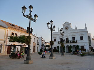
San Pedro del Pinatar is a small town and municipality in the Region of Murcia, southeastern Spain. The municipality is situated at the northern end of Murcia's Mediterranean coastline, the Costa Cálida, and borders the province of Alicante. It has an area of almost 22 km2, and a population of 25,167 as of 2018.

The Costa Brava is a coastal region of Catalonia in northeastern Spain. Sources differ on the exact definition of the Costa Brava. Usually it can be regarded as stretching from the town of Blanes, 60 km (37 mi) northeast of Barcelona, to the French border – in other words it consists of the coast of the province of Girona.

Lloret de Mar is a Mediterranean coastal town in Catalonia, Spain. It is 40 kilometres south of Girona and 75 kilometres northeast of Barcelona. With a population of 38,402 in 2021, it is the second largest town in the Selva comarca of Catalonia.
The Costa Cálida is the approximately 250 km stretch of Mediterranean coastline of the Spanish province of Murcia. This region has a micro-climate which features comparatively hot mean annual temperatures and a quite notable degree of aridity, scoring a semidesert category and in the southern parts even desert status in Koppen classification.

La Manga, or La Manga del Mar Menor is a seaside spit of Mar Menor in the Region of Murcia, Spain.
Cartaya is a Spanish locality and municipality in the Province of Huelva,. In 2010 it had 18,415 inhabitants. Its surface area is 226.4 km2 and has a density of 81.34 people per km2.

Pilar de la Horadada is a town and district in the Province of Alicante, in the southeast of Spain. Located 66 km south of Alicante, the city is the southernmost of the Valencian Community, only 1 km north of the regional border.

Los Alcázares is a municipality and a coastal spa town and former fishing village on the western side of the Mar Menor in the autonomous community and province of Murcia, southeastern Spain.

San Javier is a small town and municipality in the autonomous community and province of Murcia in southeastern Spain. The municipality is situated at the northern end of Murcia's Mediterranean coastline, the Costa Cálida.

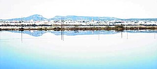
Mar Menor is a coastal saltwater lagoon in the Iberian Peninsula located south-east of the Autonomous Community of Murcia, Spain, near Cartagena. Its name is the opposite of the Mediterranean, which is the Mar Mayor of the region.

Fornells de Mar, also known as Platja de Fornells or simply Fornells, is a village, bay and port on the Costa Brava and in the municipality of Begur, Catalonia, Spain. It lies between Sa Tuna and Tamariu. It was formerly mainly a fishing village and there is still some fishing activity.
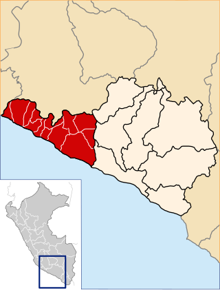
Caravelí is one of eight provinces in the Arequipa Region of Peru, with its capital in the city of Caravelí. It borders the department of Ayacucho to the north; the provinces of La Unión, Condesuyos, and Camaná to the east; the Pacific Ocean to the south; and the department of Ica to the west.

Fuente Álamo de Murcia is a town and municipality in the Region of Murcia, southern Spain. It is situated 22 km northwest of Cartagena and 35 km south west of Murcia. The town lies in the basin of the Mar Menor surrounded by the mountains of Algarrobo, Los Gómez, Los Victorias and the Carrascoy.

The Region of Murcia is an autonomous community of Spain located in the southeastern part of the Iberian Peninsula, on the Mediterranean coast. The region is 11,313 km2 (4,368 sq mi) in area and had a population of 1,511,251 as at the start of 2020. About a third of its population lives in the capital, Murcia, and a seventh in the second city, Cartagena. At 2,014 m (6,608 ft), the region's highest point is Los Obispos Peak in the Massif of Revolcadores.

Cartagena is a Spanish city and a major naval station on the Mediterranean coast, south-eastern Iberia. As of January 2018, it has a population of 218,943 inhabitants. This makes Cartagena Murcia's second-largest municipality and Spain's sixth-largest city that is not a provincial-capital. The wider urban or metropolitan area of Cartagena, known as Campo de Cartagena, has a population of 409,586 inhabitants.

Calblanque Regional Park, Monte de las Cenizas y Peña del Águila is a regional park in the south-east of Spain, and in this country in the autonomous community Región de Murcia. In this region, it is located in the municipalities Cartagena and La Unión. It is part of Sierra Minera, a mountain chain in the Baetic System.

The Spanish municipality of Cartagena has 24 districts, known as diputaciones (councils). The original 17 districts established at the beginning of the 18th century were maintained throughout that century, and were the equivalent of the pedanías in other areas. This administrative structure was put in place in response to population increase in that era, and because the municipality was becoming less tractable.

The Cartagena–Los Nietos line is a narrow-gauge railway in the Murcia Region of Spain, connecting the city of Cartagena with smaller satellite towns to its east.

Llano del Beal is a town in the municipality of Cartagena in the autonomous community of the Region of Murcia in Spain.
Portmán is a locality in the Region of Murcia, Spain, located to the south of the municipality of La Unión at the foot of the mining mountain range of Cartagena-La Unión in a bay bathed by the Mediterranean Sea.