Related Research Articles

Mission San Luis Obispo de Tolosa is a Spanish mission founded September 1, 1772 by Father Junípero Serra in San Luis Obispo, California. Named after Saint Louis of Anjou, the bishop of Toulouse, the mission is the namesake of San Luis Obispo. The mission offers public tours of the church and grounds.
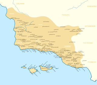
The Chumash are a Native American people of the central and southern coastal regions of California, in portions of what is now Kern, San Luis Obispo, Santa Barbara, Ventura and Los Angeles counties, extending from Morro Bay in the north to Malibu in the south to Mt Pinos in the east. Their territory included three of the Channel Islands: Santa Cruz, Santa Rosa, and San Miguel; the smaller island of Anacapa was likely inhabited seasonally due to the lack of a consistent water source.

Baywood-Los Osos is an unincorporated community in western San Luis Obispo County, California. The population was 14,351 in the 2000 census. It includes the communities of Los Osos, which is located near Morro Bay, Baywood Park, and the former community of Cuesta-by-the-Sea.

The Channel Islands are an eight-island archipelago located within the Southern California Bight in the Pacific Ocean, off the coast of California. The four Northern Channel Islands are part of the Transverse Ranges geologic province, and the four Southern Channel Islands are part of the Peninsular Ranges province. Five of the islands are within the Channel Islands National Park, and the waters surrounding these islands make up Channel Islands National Marine Sanctuary. The Nature Conservancy was instrumental in establishing the Channel Islands National Marine Sanctuary.

Santa Rosa Island is the second largest of the Channel Islands of California at 53,195 acres. Santa Rosa is located about 26 miles (42 km) off the coast of Santa Barbara, California in Santa Barbara County and is part of Channel Islands National Park.
Morro Bay State Park is a state park on the Morro Bay lagoon, in western San Luis Obispo County, on the Central Coast of California. On the lagoon's northeastern and eastern edges in the park, there are saltwater and brackish marshes that support thriving bird populations.

Chumashan was a family of languages that were spoken on the southern California coast by Native American Chumash people, from the Coastal plains and valleys of San Luis Obispo to Malibu, neighboring inland and Transverse Ranges valleys and canyons east to bordering the San Joaquin Valley, to three adjacent Channel Islands: San Miguel, Santa Rosa, and Santa Cruz.

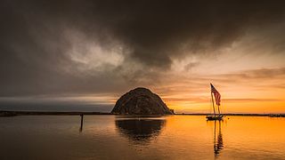
Morro Rock is a volcanic plug in Morro Bay, California, on the Pacific Coast at the entrance to Morro Bay harbor. A causeway connects it with the shore, making it a tied island. The rock is protected as the Morro Rock State Preserve.

Los Osos is an unincorporated town and census-designated place (CDP) in San Luis Obispo County, California, United States. Located on the Central Coast of California, Los Osos had a population estimated to be 16,533 in 2019.

Montaña de Oro is a state park in Central Coastal California, six miles southwest of Morro Bay and two miles south of Los Osos.
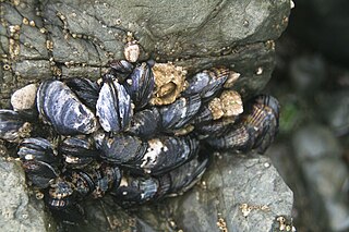
The California mussel is a large edible mussel, a marine bivalve mollusk in the family Mytilidae.

Los Osos Oaks State Natural Reserve is a California State Park in western San Luis Obispo County, in the Central Coast of California region. It preserves centuries-old coast live oaks growing atop relict sand dunes. It is located in the Los Osos Valley between San Luis Obispo and Baywood Park-Los Osos, just outside the town of Los Osos. The 85-acre (34 ha) park was established in 1972.
Los Osos Creek is a stream in coastal San Luis Obispo County that discharges to Morro Bay. Los Osos Creek rises in the Clark Valley on the slopes of the Irish Hills. After flowing through Clark Valley, Los Osos Creek flows into Los Osos Valley. In prehistoric times Chumash Native Americans had a significant settlement on a stabilized sand dune near the mouth of Los Osos Creek.
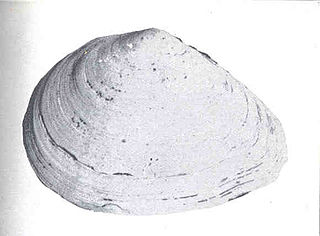
Macoma nasuta, commonly known as the bent-nosed clam, is a species of bivalve found along the Pacific Ocean coast of North America. It is about 6 cm (2.4 in) long. It is often found buried in sands of 10–20 cm (3.9–7.9 in) in depth. This rounded clam has no radial ribs. Archaeological data supports the use of this species by Native Americans such as the Chumash peoples of central California.
Dentalium neohexagonum is a species of tusk shell, a marine scaphopod mollusk in the family Dentaliidae. As the Latin name implies, the cross section of this shell is hexagonal; hence its common name is six-sided tusk shell.

The Los Osos Valley is a valley within San Luis Obispo County, in the Central Coast of California region.

The Burro Flats site is a painted cave site located near Burro Flats, in the Simi Hills of eastern Ventura County, California, United States. The Chumash-style "main panel" and the surrounding 25-acres were listed on the National Register of Historic Places in 1976, with a boundary decrease in 2020. The main panel includes dozens of pictographs in a variety of colors. The cave is in the mountains, near the bi-lingual Chumash/Fernandeno village of Huwam/Jucjauynga. The Burro Flats painted cave and the rest of the former Santa Susana Field Laboratory are not accessible to the public.

Shalawa Meadow is a 3-acre (0.012 km2) seaside meadow used in ancient times as a burial site by the Chumash people, adjoining a once large Chumash community about 5 miles east of Santa Barbara, California in the community of Montecito.

The Elfin Forest Natural Area is a nature preserve protecting a unique plant community in Los Osos-Baywood Park, San Luis Obispo County, central California. It consists of prehistoric sand dunes, rising 150 feet (46 m) above southern Morro Bay, on the north of Los Osos-Baywood Park.
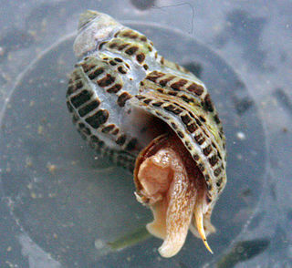
Acanthinucella spirata is a species of predatory sea snail, a marine gastropod mollusk in the family Muricidae, the murex snails or rock snails.
References
- 1 2 C. Michael Hogan. 2008. , Los Osos Back Bay, Megalithic Portal, editor A. Burnham
- ↑ C. Rick Torben and Jon M.Erlandson. 2000. Early Holocene Fishing Strategies on the California Coast: Evidence from CA-SBA-2057, Journal Arch. Sci. 27
| | This San Luis Obispo County, California-related article is a stub. You can help Wikipedia by expanding it. |