
Seville is the capital and largest city of the Spanish autonomous community of Andalusia and the province of Seville. It is situated on the lower reaches of the River Guadalquivir, in the southwest of the Iberian Peninsula.

Córdoba, or sometimes Cordova, is a city in Andalusia, Spain, and the capital of the province of Córdoba. It is the third most populated municipality in Andalusia and the 11th overall in the country.

Núñez is a barrio or neighbourhood of Buenos Aires, Argentina. It is on the northern edge of the city on the banks of the Rio de la Plata. The barrio of Belgrano is to the southeast; Saavedra and Coghlan are to the west; and Vicente López, in Buenos Aires Province, is to the north.

Avenida Corrientes is one of the principal thoroughfares of the Argentine capital of Buenos Aires. The street is intimately tied to the tango and the porteño sense of identity. Like the parallel avenues Santa Fe, Córdoba, and San Juan, it takes its name from one of the Provinces of Argentina.
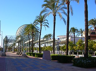
Isla de la Cartuja is an island in the Guadalquivir River at Seville, Spain.

Macarena is one of the eleven districts into which the city of Seville, capital of the autonomous community of Andalucía, Spain, is divided for administrative purposes. It is located in the north of the city, bordered to the south by the Casco Antiguo and San Pablo-Santa Justa suburbs, to the east and north by Norte and to the west by Triana. It covers the area between the Guadalquivir River and the Carmona Highway and from the SE-30 ring-road in the north to the Ronda del Casco Antiguo. It contains smaller neighbourhoods such as León XIII, Miraflores, and the Polígono Norte as well as the Miraflores park along the SE-30. The district contains the Andalucian Parliament, the Torre de los Perdigones in the park of the same name, and the Hospital Universitario Virgen Macarena

Triana is a neighbourhood and administrative district on the west bank of the Guadalquivir River in the city of Seville, Spain. Like other neighborhoods that were historically separated from the main city, it was known as an arrabal. Triana is located on a peninsula between two branches of the Guadalquivir, narrowly linked to the mainland in the north. Two other districts are also usually included in this area, Los Remedios to the south and La Cartuja to the north.

The Alameda de Hércules , or simply La Alameda, is a garden square or mall in Seville, southern Spain. Built in 1574, it was originally a promenaded public garden, named after the eight rows of white poplar trees that fill its central part. Located in the northern half of the city's casco antiguo, between the Guadalquivir River and the Macarena neighbourhood, it was the oldest public garden in Spain and Europe.

El Arenal is a neighbourhood in the historical centre of Seville, the Casco Antiguo. It lies on the east bank of the Guadalquivir river to the west of the old Jewish Quarter, Santa Cruz, and south of the neighbourhoods of Museo and Alfalfa. Its name comes from the sandy nature that this east bank of the river once used to have. El Arenal has a history characterised by its former position as the port of Seville, until river silting forced the city to relocate the port to the southern edge of the city in the 17th century.

The Casco Antiguo is the city centre district of Seville, the capital of the Spanish region of Andalusia. The Casco Antiguo comprises Seville's old town, which lies on the east bank of the Guadalquivir river. It borders the districts of Macarena to the north, Nervión and San Pablo-Santa Justa to the east, and the Distrito Sur to the south. Bridges across the Guadalquivir link the Casco Antiguo to Los Remedios, Triana and La Cartuja.

Gelves is a city located in the province of Seville, in Andalusia, Spain. According to the 2006 census (INE), the city has a population of 8,325 inhabitants. It lies on the west bank of the Guadalquivir river.
San Juan de Aznalfarache is a city located in the province of Seville, Spain. According to the 2006 census (INE), the city has a population of 20,121 inhabitants.
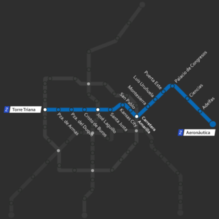
The Line 2 of the Metro of Seville will span the city from east to west, connecting the neighbourhoods of La Cartuja and Torreblanca.

Plaza de Cuba is a station of the Seville Metro on the line 1. It is located at the intersection of the avenue of República Argentina and Asunción St., in the neighborhood of Los Remedios. Plaza de Cuba is an underground station, located between Parque de los Príncipes and Puerta Jerez stations on the same line. It was opened on 2 April 2009.
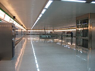
Parque de los Príncipes is a station of the Seville Metro on the line 1. It is located at the intersection of the avenues of República Argentina and López de Gomara, in the neighborhood of Los Remedios. Parque de los Príncipes is an underground station, located between Blas Infante and Plaza de Cuba stations on the same line. It was opened on April 2, 2009. Is expected that in the future, the station will have a connection with the line 4 of the subway.

Seville, the capital of the region of Andalusia in Spain, has 11 districts, further divided into 108 neighbourhoods.

Bellavista-La Palmera is a district of the city of Seville, the regional capital of the Spanish region of Andalusia. It is situated on the eastern bank of the Guadalquivir river, to the south of the city centre.
There are numerous sights and landmarks of Seville. The most important sights are the Alcázar, the Seville Cathedral, and the Archivo General de Indias, which are UNESCO World Heritage Sites.
The following is a timeline of the history of the city of Seville, Andalusia, Spain.
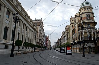
Avenida de la Constitución is an important avenue in the Casco Antiguo district of Seville, Andalusia, Spain. It starts from the square known as Puerta de Jerez and reaches the Plaza Nueva, considered the center of the city and where the historic building of the Seville City Council is located. It has a length of 600 m (0.37 mi).

