The Public Land Survey System (PLSS) is the surveying method developed and used in the United States to plat, or divide, real property for sale and settling. Also known as the Rectangular Survey System, it was created by the Land Ordinance of 1785 to survey land ceded to the United States by the Treaty of Paris in 1783, following the end of the American Revolution. Beginning with the Seven Ranges in present-day Ohio, the PLSS has been used as the primary survey method in the United States. Following the passage of the Northwest Ordinance in 1787, the Surveyor General of the Northwest Territory platted lands in the Northwest Territory. The Surveyor General was later merged with the General Land Office, which later became a part of the U.S. Bureau of Land Management (BLM). Today, the BLM controls the survey, sale, and settling of lands acquired by the United States.
This aims to be a complete list of the articles on real estate.
A township in some states of the United States is a small geographic area.

In the United States, a plat (plan) is a cadastral map, drawn to scale, showing the divisions of a piece of land. United States General Land Office surveyors drafted township plats of Public Lands Surveys to show the distance and bearing between section corners, sometimes including topographic or vegetation information. City, town or village plats show subdivisions broken into blocks with streets and alleys. Further refinement often splits blocks into individual lots, usually for the purpose of selling the described lots; this has become known as subdivision.
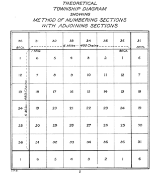
In U.S. land surveying under the Public Land Survey System (PLSS), a section is an area nominally one square mile, containing 640 acres, with 36 sections making up one survey township on a rectangular grid.
Metes and bounds is a system or method of describing land, real property or real estate. The system has been used in England for many centuries and is still used there in the definition of general boundaries. The system is also used in the Canadian province of Ontario, and throughout Canada for the description of electoral districts. By custom, it was applied in the original Thirteen Colonies that became the United States and in many other land jurisdictions based on English common law, including Zimbabwe, South Africa, India and Bangladesh. While still in hand-me-down use, this system has been largely overtaken in the past few centuries by newer systems such as rectangular and lot and block.
Subdivisions are the act of dividing land into pieces that are easier to sell or otherwise develop, usually via a plat. The former single piece as a whole is then known as a subdivision. Subdivisions may be simple, involving only a single seller and buyer, or complex, involving large tracts of land divided into many smaller parcels. If it is used for housing it is typically known as a housing subdivision or housing development, although some developers tend to call these areas communities.

A cadastre or cadaster is a comprehensive recording of the real estate or real property's metes-and-bounds of a country. Often it is represented graphically in a cadastral map.
In surveying and property law, a land description or legal description is a written statement that delineates the boundaries of a piece of real property. In the written transfer of real property, it is universally required that the instrument of conveyance (deed) include a written description of the property.
In real estate, a lot or plot is a tract or parcel of land owned or meant to be owned by some owner(s). A plot is essentially considered a parcel of real property in some countries or immovable property in other countries. Possible owner(s) of a plot can be one or more person(s) or another legal entity, such as a company/corporation, organization, government, or trust. A common form of ownership of a plot is called fee simple in some countries.
A tract index is a document which summarizes real property transactions in certain U.S. states and may be available in the offices of Recorder of deeds.
George L. Kinnard was a Representative from Indiana; born in Pennsylvania in 1803; moved with his widowed mother to Tennessee and completed preparatory studies; moved to Indianapolis, Ind., in 1823; studied law; was admitted to the bar and practised in Marion County, Indiana; assessor for Marion County in 1826 and 1827; member of the State house of representatives 1827–1830; county surveyor 1831–1835; colonel of the State militia; elected as a Jacksonian to the Twenty-third and Twenty-fourth Congresses and served from March 4, 1833, until his death on November 26, 1836; interment probably in Presbyterian Burying Ground, Cincinnati, Ohio.
Gaps and gores are portions of land areas that do not conform to boundaries found in cadastre and other land surveys based upon imprecise measurements and other ambiguities of metes and bounds. A gap, also known as a hiatus, occurs where the descriptions in deeds describing adjacent properties (unintentionally) overlook a space or "gap" between them. A gore occurs where descriptions in larger administrative boundaries of adjacent jurisdictions or, large parcels, all fail to include some portion of land between them, forming an unclaimed, characteristically triangular "sliver" of land.
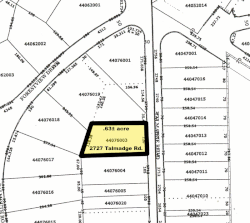
An assessor's parcel number, or APN, is a number assigned to parcels of real property by the tax assessor of a particular jurisdiction for purposes of identification and record-keeping. The assigned number is unique within the particular jurisdiction, and may conform to certain formatting standards that convey basic identifying information such as the property type or location within the plot map.
A unit of real estate or immovable property is limited by a legal boundary. The boundary may appear as a discontinuation in the terrain: a ditch, a bank, a hedge, a wall, or similar, but essentially, a legal boundary is a conceptual entity, a social construct, adjunct to the likewise abstract entity of property rights.
Manhattan was a proposed city in a development that was located in northern Manatee County, Florida near the present-day town of Parrish during the Florida land boom in the 1920s. The town was intended to be the centerpiece of an agricultural community called Manatee River Park Estates.
Cadastral surveying is the sub-field of cadastre and surveying that specialises in the establishment and re-establishment of real property boundaries. It involves the physical delineation of property boundaries and determination of dimensions, areas and certain rights associated with properties. This is regardless of whether they are on land, water or defined by natural or artificial features. It is an important component of the legal creation of properties. A cadastral surveyor must apply both the spatial-measurement principles of general surveying and legal principles such as respect of neighboring titles.

In English common law, real property, real estate, immovable property or, solely in the US and Canada, realty, is land which is the property of some person and all structures integrated with or affixed to the land, including crops, buildings, machinery, wells, dams, ponds, mines, canals, roads, and other things. The term is historic, arising from the now-discontinued form of action, which distinguished between real property disputes and personal property disputes. Personal property, or personalty, was, and continues to be, all property that is not real property.
Texas, along with the original thirteen states and several others in the Southwest which were originally deeded with Spanish land grants, does not use the Public Land Survey System. Land grants from the state of Texas to railroad companies were often patented in blocks and sections, and occasionally in units of square miles, officially considered sections.

Butts and bounds, shortened form for "abuttals and boundaries" of a property, are the boundary lines delineated between plots of land, usually those which define the end of an estate, as used in legal deeds, titles, etc. These are usually descriptive features in the property, such as trees, outcroppings of stone, or riverine brooks, etc., and are signified in the legal deed for purposes of identification.