Related Research Articles

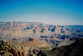
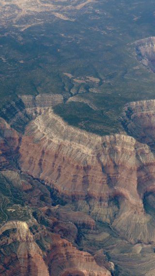
The Grand Canyon is a steep-sided canyon carved by the Colorado River in Arizona, United States. The Grand Canyon is 277 miles (446 km) long, up to 18 miles (29 km) wide and attains a depth of over a mile.

Edward Lawrence Schieffelin (1847–1897) was an Indian scout and prospector who discovered silver in the Arizona Territory, which led to the founding of Tombstone, Arizona. He entered into a partnership with his brother Al and mining engineer Richard Gird in a handshake deal that produced millions of dollars in wealth for all three men. During the course of Tombstone's mining history, about US $85,000,000 in silver was produced from its mines.

The Bright Angel Trail is a hiking trail located in Grand Canyon National Park in the U.S. state of Arizona.

The known human history of the Grand Canyon area stretches back 10,500 years, when the first evidence of human presence in the area is found. Native Americans have inhabited the Grand Canyon and the area now covered by Grand Canyon National Park for at least the last 4,000 of those years. Ancestral Pueblo peoples, first as the Basketmaker culture and later as the more familiar Pueblo people, developed from the Desert Culture as they became less nomadic and more dependent on agriculture. A similar culture, the Cochimi also lived in the canyon area. Drought in the late 13th century likely caused both groups to move on. Other people followed, including the Paiute, Cerbat, and the Navajo, only to be later forced onto reservations by the United States Government.
British Columbia gold rushes were important episodes in the history and settlement of European, Canadian and Chinese peoples in western Canada.

Phantom Ranch is a lodge inside Grand Canyon National Park in Arizona. It sits at the bottom of Grand Canyon, on the east side of Bright Angel Creek, a little over half a mile north of the Creek's confluence with the Colorado River. Opened in 1922, Phantom Ranch is a member of Historic Hotels of America, the official program of the National Trust for Historic Preservation.

The Cariboo Gold Rush was a gold rush in the Colony of British Columbia, which later became the Canadian province of British Columbia. The first gold discovery was made at Hills Bar in 1858, followed by more strikes in 1859 on the Horsefly River, and on Keithley Creek and Antler Creek in 1860. The actual rush did not begin until 1861, when these discoveries were widely publicized. By 1865, following the strikes along Williams Creek, the rush was in full swing.

Hermits Rest is a structure built in 1914 at the western end of Hermit Road at the south rim of the Grand Canyon in Arizona, United States. The Hermit Trail, a hiking trail that extends to the Colorado River, begins about ¼ mile beyond the shuttle bus stop at Hermits Rest. Hermits Rest also represents the western terminus of the Rim Trail. The location was named for Louis Boucher. Around 1891, Boucher – a Canadian-born prospector – staked claims below present-day Hermits Rest. With help, Boucher carved the aforementioned trail into the canyon, and for years lived alone at nearby Dripping Springs. The main structure currently standing at Hermits Rest was designed by architect Mary Colter. Hermits Rest is the westernmost point on the canyon's south rim that is accessible by paved road. It was built as a rest area for tourists on coaches operated by the Fred Harvey Company on the way to the now-vanished Hermit Camp. The building was designed to appear to be a natural stone formation, closely tied to the land. Colter selected furnishings that are included in the National Historic Landmark designation.

The Fraser Canyon Gold Rush, began in 1858 after gold was discovered on the Thompson River in British Columbia at its confluence with the Nicoamen River a few miles upstream from the Thompson's confluence with the Fraser River at present-day Lytton. The rush overtook the region around the discovery and was centered on the Fraser Canyon from around Hope and Yale to Pavilion and Fountain, just north of Lillooet.

The Douglas Road, a.k.a. the Lillooet Trail, Harrison Trail or Lakes Route, was a goldrush-era transportation route from the British Columbia Coast to the Interior. Over 30,000 men are reckoned to have travelled the route in, although by the end of the 1860s it was virtually abandoned due to the construction of the Cariboo Wagon Road, which bypassed the region.

The Hermit Trail is a hiking trail in Grand Canyon National Park, located in the U.S. state of Arizona. This trail provides access to a historic area of Grand Canyon and offers a more challenging route to the Colorado River for more experienced canyon hikers.

The Tonto Trail is a hiking trail on the South Rim of the Grand Canyon in Grand Canyon National Park, located in the U.S. state of Arizona.

The Boucher Trail is a hiking trail of the South Rim in Grand Canyon National Park, located in the U.S. state of Arizona.
The Grandview Trail is a hiking trail located on the South Rim of the Grand Canyon National Park, located in the U.S. state of Arizona.It was built in 1893 by miners and is noted for its cobblestone and cribbing sections.
The Dripping Springs Trail is a hiking trail on the South Rim of the Grand Canyon National Park, located in the U.S. state of Arizona.
The River Trail was a main route for travel in the colonial era of what is now the Canadian province of British Columbia, running northwards along the Fraser River from to present day Lillooet to Big Bar, British Columbia and points beyond in the Cariboo District. The route was primarily in use during the Fraser Canyon Gold Rush and associated explorations by prospectors northwards in the search for gold in the Cariboo and Omineca Districts.
The Lost Adams Diggings are the subject of a Southwestern treasure story, dating to the early 1860s, that refers to the existence of a canyon rich in gold deposits somewhere in western New Mexico.
Gold Trails and Ghost Towns is a Canadian historical documentary show, created and produced by television station CHBC-TV in Kelowna, British Columbia for Canadian syndication and hosted by Mike Roberts with historian/storyteller Bill Barlee. The show was filmed in a studio which resembled an old trapper's cabin. Mike and Bill discussed prospectors and the history of British Columbia around 1900.
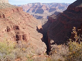
Hermit Canyon is a north-trending canyon in western Grand Canyon, about 6.0 miles in length, below the South Rim. It is named for the hermit who built Hermit Camp, at the Colorado River, Louis D. Boucher. Hermit Canyon's east flank is bordered by Pima Point of the South Rim, and Pima Point is ~2.0 from the Hermit Canyon midline. Pima Point is about 3.5 miles west-northwest of Grand Canyon Village, and the South Rim at Pima Point trends southward, as the start of Western Grand Canyon; it also marks the terminus of the West Rim Road.
References
- 1 2 Drew, Daryl (October 2015). "Louis Boucher: Canadian Guide Of The Grand Canyon". Canadian Cowboy Country Magazine. Tanner Young. Retrieved 8 August 2018.
- ↑ "Grand Canyon National Park (Notes)". npshistory.com. Retrieved 2018-08-29.
- ↑ "Hermit Camp – National Park Lodge Architecture Society". www.nplas.org. Retrieved 2018-08-29.
- ↑ James, George. "Dripping Spring And The Boucher Trail". Geo Cities. Retrieved 8 August 2018.
- ↑ "NCHGC: Sites and Stories: Rim to River: Boucher Trail". www.grcahistory.org. Retrieved 2018-08-29.