
Brussels, officially the Brussels-Capital Region, is a region of Belgium comprising 19 municipalities, including the City of Brussels, which is the capital of Belgium. The Brussels-Capital Region is located in the central portion of the country and is a part of both the French Community of Belgium and the Flemish Community, but is separate from the Flemish Region and the Walloon Region. Brussels is the most densely populated and the richest region in Belgium in terms of GDP per capita. It covers 162 km2 (63 sq mi), a relatively small area compared to the two other regions, and has a population of over 1.2 million. The five times larger metropolitan area of Brussels comprises over 2.5 million people, which makes it the largest in Belgium. It is also part of a large conurbation extending towards Ghent, Antwerp, Leuven and Walloon Brabant, home to over 5 million people.

Leopold I was the first King of the Belgians, reigning from 21 July 1831 until his death in 1865.

There are twelve provinces of the Netherlands, representing the administrative layer between the national government and the local municipalities, with responsibility for matters of subnational or regional importance.

Maarkedal is a municipality located in the Belgian province of East Flanders. The municipality comprises the towns of Etikhove, Maarke-Kerkem, Nukerke and Schorisse, and part of the hamlet of Louise-Marie. On January 1, 2006, Maarkedal had a total population of 6,332. The total area is 45.63 km2 which gives a population density of 139 inhabitants per km2.

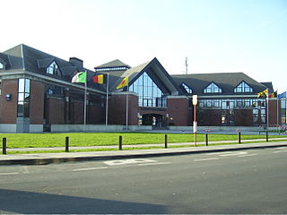
Ronse is a Belgian city and a municipality in the Flemish province of East Flanders. The municipality only encompasses the city of Ronse proper.

Laeken or Laken is a residential suburb in the north-western part of the Brussels-Capital Region, Belgium. It belongs to the municipality of the City of Brussels and is mostly identified by the Belgian postal code: 1020. Prior to 1921, it was a separate municipality.
Waterloo is a municipality in Wallonia, located in the province of Walloon Brabant, Belgium, which in 2011 had a population of 29,706 and an area of 21.03 km2 (8.12 sq mi). Waterloo lies a short distance south of Brussels, and immediately north-east of the larger town of Braine-l'Alleud, the site of the Battle of Waterloo, where the resurgent Napoleon was defeated for the final time in 1815. Waterloo lies immediately south of the official language border between Flanders and Wallonia.

The Flemish Region, usually simply referred to as Flanders, is one of the three regions of Belgium—alongside the Walloon Region and the Brussels-Capital Region. It occupies the northern part of Belgium and covers an area of 13,625 km2 (5,261 sq mi). It is one of the most densely populated regions of Europe with around 490/km2 (1,300/sq mi).

Ixelles or Elsene, is one of the 19 municipalities of the Brussels-Capital Region, Belgium. Located to the south-east of Brussels' city centre, it is geographically bisected by the City of Brussels. It is also bordered by the municipalities of Auderghem, Etterbeek, Forest, Uccle, Saint-Gilles and Watermael-Boitsfort.

Doel is a subdivision of the municipality of Beveren in the Flemish province of East Flanders in Belgium. It is located near the river the Scheldt, in a polder of the Waasland. Since 1965, there have been plans to extend the Port of Antwerp into Doel and demolish the village, however protests have caused a stalemate.
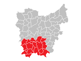
The Flemish Ardennes is an informal name given to a hilly region in the south of the province of East Flanders, Belgium. Highest summit is the Hotondberg. Main characteristics of the region are rural hilly landscapes with hilltop bluebell woodlands, windmills and watermills.

Melsele is a town in the Belgian province of East Flanders, between the city of Beveren and the nearby town of Zwijndrecht. Tram route 3 which starts just outside the town connects it to Zwijndrecht and Antwerp. The town's road links include the E17 and the E34.

Nederbrakel is a town in the municipality of Brakel. It is located in the Denderstreek and in the Flemish Ardennes, the hilly southern part of the province of East Flanders, Belgium. With 5,972 residents as of 2000, it forms the largest individual part of the municipality. Nederbrakel is located near the language border.
Michelbeke is a village in the municipality of Brakel, Belgium. It is located in the Denderstreek and in the Flemish Ardennes, the hilly southern part of the province of East Flanders, Belgium. It was itself a municipality until the fusion of the municipalities on 1 January 1971.

Melden is a village belonging partly to the municipality of Oudenaarde and partly to the municipality of Kluisbergen. It is located in the Flemish Ardennes, the hilly southern part of the province of East Flanders, Belgium.

Opbrakel is a village and deelgemeente (sub-municipality) of the municipality of Brakel. It is located in the Denderstreek in the province of East Flanders in Belgium. It used to be an independent municipality until 1971 when it was merged into Brakel.
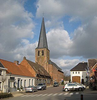
Maarke-Kerkem is a village in the Flemish Ardennes, the hilly southern part of the province of East Flanders, Belgium. It is formed by two hamlets, Maarke and Kerkem, and is incorporated in the municipality of Maarkedal. It is hosting the Saint Vincent Chapel, which was first erected around 1100.

Princess Stéphanie, Hereditary Grand Duchess of Luxembourg, is the wife of Hereditary Grand Duke Guillaume, heir apparent to the throne of Luxembourg. She became engaged to the Hereditary Grand Duke on 26 April 2012 and married him, in a civil ceremony, on 19 October 2012, followed by a religious service the next day. The couple have a son, Prince Charles.

Watervliet is a village in the Belgian province of East Flanders and suburb of the town of Sint-Laureins. Watervliet is part of the Meetjesland, and is adjacent to the Dutch border. It was a separate municipality until 1977.

The Louvain School of Engineering or École polytechnique de Louvain (EPL) is a faculty of the University of Louvain, Belgium, founded in 1864. Known as the Faculty of Applied Sciences prior to 2008, it currently operates on the campuses of Louvain-la-Neuve and UCLouvain Charleroi.


