Louisiana Highway 1065

Last updated

Louisiana 1065 (2008).svg

Louisiana Highway 1065

LA 1065 map.svg
Route information
Maintained by Louisiana DOTD
Length11.1 mi (17.9 km)
Existed 1955 renumbering–present
Major junctions
South endUS 190.svg US 190 in Hammond
Major intersectionsLouisiana 3234 (2008).svg LA 3234 in Hammond
Louisiana 1064 (2008).svg LA 1064 in Tickfaw
Louisiana 442 (2008).svg LA 442 in Tickfaw
North endUS 51.svgLouisiana 1063 (2008).svg US 51  / LA 1063 in Independence
Location
Country United States
State Louisiana
Parishes Tangiapahoa
Highway system
  • Louisiana State Highway System
Louisiana 1064 (2008).svg LA 1064 Louisiana 1067 (2008).svg LA 1067

Louisiana Highway 1065 (LA 1065) is a mostly rural highway in Tangipahoa Parish, Louisiana between Hammond and Independence. In its more trafficked southern end it is known as North Cherry Street and outside Hammond, North Cherry Street Extension. LA 1065 is a two-lane highway for the entirety of its 11.1-mile-length (17.9 km).

Contents

Route description

From the south, LA 1065 begins at US 190 in Hammond's Historic District. Proceeding due north, it bridges Ponchatoula Creek and forms a T-intersection with LA 3234 (University Avenue) on the west. It leaves Hammond and enters Tickfaw, crossing crosses LA 1064 (Natalbany Road) and LA 442. North of LA 442, LA 1065 enters Independence and has six sharp turns, the last cosigning it with Cypress Street near central Independence. At the intersection of Cypress Street and Tiger Avenue (so named because the tiger is the mascot of adjacent Independence High School), LA 1065 turns west to follow Tiger Avenue in crossing the Canadian National Railway and immediately to end at the perpendicular US 51 (West Railroad Avenue); directly across that intersection, LA 1063 (cosigned with Fifth Street) assumes the trajectory of LA 1065 and Tiger Avenue.

LA 1065 has its southern terminus in Hammond's Historic District. The building in the left background is Dantone's Grocery, founded in 1912 by Italian immigrants. LA 1065 Hammond terminus Dantone.JPG
LA 1065 has its southern terminus in Hammond's Historic District. The building in the left background is Dantone's Grocery, founded in 1912 by Italian immigrants.

LA 1065 supports egress for Southeastern Louisiana University via LA 3234. Additionally, it serves significantly as a farm-to-market road and, together with LA 442, facilitates recreational access to the Tangipahoa River.

History

LA 1065 is an old road, its original role in connecting Hammond and Independence having been assumed in the 1930s by US 51, which was in turn sidelined in the 1960s by I-55.

LA 1065 has an anomaly at its southern terminus. US 190 at that point was originally a two-way route entirely on Thomas Street in Hammond. In the 1960s US 190 in Hammond was reconstructed as a divided highway, with westbound traffic on Thomas Street and eastbound traffic one block south on Morris Street. But in the change, accidentally, no provision was made for the one block of Cherry Street between Morris Street and Thomas Street to become state highway. As an afterthought, traffic eastbound on US 190 has a sign reading "TO" LA 1065 with a left arrow. Officially, traffic is not on LA 1065 until it is north of Thomas Street.

Major intersections

The entire highway is in Tangipahoa Parish.

Locationmi [1] kmDestinationsNotes
Hammond 0.000.00US 190.svg US 190 Southern terminus
1.081.74Louisiana 3234 (2008).svg LA 3234 (University Avenue)
Tickfaw 3.135.04Louisiana 1064 (2008).svg LA 1064 (Natalbany Road)
5.568.95Louisiana 442 (2008).svg LA 442
Independence 10.2216.45US 51.svgLouisiana 1063 (2008).svg US 51 (West Railroad Avenue) / LA 1063 (Fifth Street)Northern terminus
1.000 mi = 1.609 km; 1.000 km = 0.621 mi

Related Research Articles

<span class="mw-page-title-main">Interstate 12</span> Interstate in Louisiana

Interstate 12 (I-12) is an intrastate Interstate Highway located entirely within the US state of Louisiana. It spans a total of 85.59 miles (137.74 km) in an east–west direction from I-10 in Baton Rouge to an interchange with both I-10 and I-59 in Slidell. Along the way, it passes through the city of Hammond, where it intersects I-55 and US Route 51 (US 51). It also serves the cities of Ponchatoula and Denham Springs, as well as the St. Tammany Parish cities of Covington and Mandeville. Skirting the northern shore of Lake Pontchartrain, I-12 serves as both a northern bypass of the New Orleans metropolitan area and an alternate route for I-10, which serves the city of New Orleans itself.

<span class="mw-page-title-main">Hammond, Louisiana</span> City in Louisiana, US

Hammond is the largest city in Tangipahoa Parish, Louisiana, United States, located 45 miles (72 km) east of Baton Rouge and 45 miles (72 km) northwest of New Orleans. Its population was 20,019 in the 2010 U.S. census, and 21,359 at the 2020 population estimates program.

<span class="mw-page-title-main">U.S. Route 190</span> Highway in the United States

U.S. Route 190 (US 190) is an east–west United States Highway in Louisiana and Texas. Segments of US 190 will be upgraded to Interstate 14 (I-14); the first 24.8-mile (39.9 km) segment was opened on January 26, 2017.

<span class="mw-page-title-main">Louisiana Highway 16</span> Highway in Louisiana

Louisiana Highway 16 (LA 16) is a state highway located in southeastern Louisiana. It runs 110.27 miles (177.46 km) in a general east–west direction from LA 22 south of French Settlement to LA 21 in Sun.

<span class="mw-page-title-main">Louisiana Highway 22</span>

Louisiana Highway 22 (LA 22) is a state highway located in southeastern Louisiana. It runs 71.15 miles (114.50 km) in a general east–west direction from the junction of LA 75 and LA 942 in Darrow to U.S. Highway 190 (US 190) in Mandeville.

<span class="mw-page-title-main">Louisiana Highway 1077</span>

Louisiana Highway 1077 (LA 1077) is a state highway located in southeastern Louisiana. It runs 20.61 miles (33.17 km) in a general north–south direction from a dead end at Lake Pontchartrain in Madisonville to a junction with LA 25 south of Folsom.

<span class="mw-page-title-main">Louisiana Highway 445</span>

Louisiana Highway 445 is a state highway in Louisiana that serves Tangipahoa Parish. It spans 24.6 miles (39.6 km) in a south to north direction. Near its north end, it is known as Husser Road.

<span class="mw-page-title-main">U.S. Route 51 in Louisiana</span> Section of U.S. Highway in Louisiana, United States

U.S. Highway 51 (US 51) is a part of the United States Numbered Highway System that spans 1,277 miles (2,055 km) from LaPlace, Louisiana to a point north of Hurley, Wisconsin. Within the state of Louisiana, the highway travels 69.12 miles (111.24 km) from the national southern terminus at US 61 in LaPlace to the Mississippi state line north of Kentwood.

<span class="mw-page-title-main">Ponchatoula Creek</span> Main waterway that flows through Hammond

Ponchatoula Creek is a 26.1-mile-long (42.0 km) tributary of the Natalbany River in Tangipahoa Parish, Louisiana. The two waterways join where a section of the Natalbany forms the boundary between Tangipahoa Parish and Livingston Parish. Ponchatoula Creek originates west of Old US Highway 51, 1 mile (1.6 km) north of Independence. The creek is entirely within Tangipahoa Parish.

<span class="mw-page-title-main">Louisiana Highway 40</span>

Louisiana Highway 40 (LA 40) is a state highway located in southeastern Louisiana. It runs 53.11 miles (85.47 km) in an east–west direction from LA 43 south of Montpelier to LA 41 in Bush.

<span class="mw-page-title-main">Louisiana Highway 43</span>

Louisiana Highway 43 (LA 43) is a state highway located in southeastern Louisiana. It runs 44.38 miles (71.42 km) in a north–south direction from LA 42 west of Springfield to the Mississippi state line north of Easleyville, where it continues as Mississippi Highway 568 (MS 568).

<span class="mw-page-title-main">U.S. Route 61/190 Business</span>

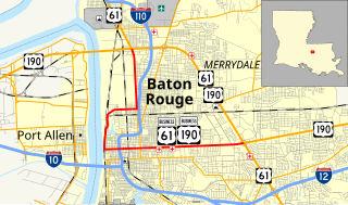
U.S. Highway 61/190 Business is a business route of both U.S. Route 61 and U.S. Route 190 in Louisiana that serves as a boulevard into downtown Baton Rouge. It spans 10.89 miles (17.53 km) in a southeast to northwest direction and it is signposted as Business 61/190, generally without directional shields. It follows parts of the former alignment of US 61/190 through Baton Rouge, which existed in downtown Baton Rouge from 1935 until 1960.

<span class="mw-page-title-main">Louisiana Highway 103</span>

Louisiana Highway 103 is a state highway in St. Landry Parish, Louisiana, United States, that spans 39.5 miles (63.6 km) in a wide semi-circle around the north side of Opelousas. The route is not bannered but runs in an overall west–east direction from U.S. Highway 190 near Lawtell to LA 31 in Leonville. Along the way, it passes through the towns of Washington and Port Barre.

References

  1. Google (October 23, 2015). "Overview Map of LA 1065" (Map). Google Maps . Google. Retrieved October 23, 2015.
Template:Attached KML/Louisiana Highway 1065
KML is from Wikidata