
Lexington is the second-most-populous city in the Commonwealth of Kentucky, and the 60th-most populous city in the United States. It is the county seat of Fayette County. By land area, it is the country's 30th-largest city.

St. Matthews is a city in Jefferson County, Kentucky, United States. It forms part of the Louisville Metro government but is separately incorporated as a home rule-class city. The population was 17,472 at the 2010 census, up from 15,852 at the 2000 census. It is the 23rd-largest city in the state. St. Matthews is one of the state's major shopping areas, home to the fifth-largest mall in Kentucky along with many smaller shopping centers along Shelbyville Road.

Sullivan University is a private for-profit university based in Louisville, Kentucky. It is licensed to offer certificates and diplomas, associate's, bachelor's, master's and doctoral degrees by the Kentucky Council on Postsecondary Education and is accredited by the Southern Association of Colleges and Schools Commission on Colleges. According to the Kentucky Council, for the 2015–2016 academic year, 40% of Sullivan's full-time, first-time associate degree students received their degrees within three years.
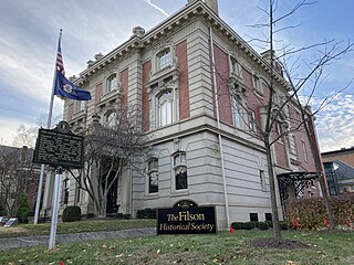
The Filson Historical Society, founded in 1884, is a privately supported historical society located at 1310 South 3rd Street in the Old Louisville neighborhood of Louisville, Kentucky. The Filson is an organization dedicated to continuing adult education through a quarterly peer-reviewed academic journal, Ohio Valley History, a quarterly magazine, The Filson, weekly lectures, historical tours, and exhibits.

James Gilbert Baker was an American astronomer and designer of optics systems.
Clifton is a neighborhood east of downtown Louisville, Kentucky USA. Clifton was named because of its hilly location on the Ohio River valley escarpment. Clifton is bounded by I-64, N Ewing Ave, Brownsboro Road, and Mellwood Ave.

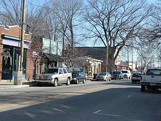
Crescent Hill is a neighborhood four miles (6 km) east of downtown Louisville, Kentucky USA. This area was originally called "Beargrass" because it sits on a ridge between two forks of Beargrass Creek. The boundaries of Crescent Hill are N Ewing Ave to the St. Matthews city limit by Brownsboro Road to Lexington Road. Frankfort Avenue generally bisects the neighborhood.
Moore Observatory is an astronomical observatory owned and operated by University of Louisville. It is located on the Horner Wildlife Refuge in Oldham County, Kentucky (USA) approximately 20 kilometers (12 mi) northeast of Louisville. It opened in 1978, and was dedicated to Walter Lee Moore, a Professor of Mathematics at U of L from 1929 to 1967.
The Point was a thriving 19th century neighborhood in Louisville, Kentucky, east of Downtown Louisville and opposite Towhead Island along the Ohio River. It was also located north of the present day Butchertown area.

Riverfront Plaza/Belvedere is a public area on the Ohio River in Downtown Louisville, Kentucky. Although proposed as early as 1930, the project did not get off the ground until $13.5 million in funding was secured in 1969 to revitalize the downtown area. On April 27, 1973, the Riverfront Plaza/Belvedere was dedicated. Running between Third and Sixth streets, it consisted of a large parking garage and the interstate, and a grassy 7-acre (28,000 m2) park built atop. The grassy park section on the western end was the Belvedere, and the Riverfront Plaza to the east included other attractions: fountains, shelters and an ice-skating rink, as well as buildings such as the Galt House, One Riverfront Plaza and the American Life Building.

E. P. "Tom" Sawyer State Park is a 550-acre (220 ha) Kentucky state park located in the Freys Hill area of Louisville, Kentucky, on former land of Kentucky's Central State Hospital. When opened in 1974, it was named in honor of Republican Jefferson County Judge/Executive Erbon Powers "Tom" Sawyer who was killed in a car accident on Louisville's Interstate 64 in 1969 while still in office. Sawyer was the father of journalist Diane Sawyer.

Fort Nelson, built in 1781 by troops under George Rogers Clark including Captain Richard Chenoweth, was the second on-shore fort on the Ohio River in the area of what is now downtown Louisville, Kentucky. Fort-on-Shore, the downriver and first on-shore fort, had proved to be insufficient barely three years after it was established. In response to continuing attacks from Native Americans and the threat of British attacks during the Revolutionary War, Fort Nelson was constructed between what is currently Main Street and the river, with its main gate near Seventh Street. It was named after Thomas Nelson Jr., then the governor of Virginia.

Rooster Run was a general store in Nelson County, Kentucky. Joe Evans opened the store in 1967. It was known for the baseball caps featuring its logo and the fiberglass rooster statue standing in front of the store. It has been called "one of the best-known general stores in the country and one of Kentucky's best-known unincorporated businesses". Though not an official Kentucky community, the location is on state highway maps and receives mail with the zip code of Cox's Creek. Evans used the store's notoriety in unsuccessful bids for political office.

The Episcopal Diocese of Kentucky is a diocese of the Episcopal Church in the United States of America, encompassing the western half of the state of Kentucky.

Walnut Street Baptist Church is a Southern Baptist, Christian former megachurch in Louisville, Kentucky. It is associated with the Southern Baptist Convention, Kentucky Baptist Convention, and the Long Run Baptist Association.

WLKT is a commercial radio station licensed to Lexington-Fayette, Kentucky. The station is owned by iHeartMedia, Inc. who determines its programming in New York using automation, non-local talent, and airs a Top 40 (CHR) radio format. The station's studios are located on Nicholasville Road in south Lexington, and its transmitter is located in rural far east Fayette County, Kentucky.
Kentucky Correctional Institution for Women (KCIW) is a prison located in unincorporated Shelby County, Kentucky, near Pewee Valley, Kentucky, operated by the Kentucky Department of Corrections. Male and female inmates prior to 1937 had been housed at the Kentucky State Penitentiary in Frankfort

Powell Observatory is an astronomical observatory located near Louisburg in Miami County, Kansas. It features several large telescopes and is available for public viewing, for private use of Astronomical Society of Kansas City members, and for ongoing research projects.
Rockcreek-Lexington Road is an irregular-shaped neighborhood in Louisville, Kentucky, United States. Its boundaries are Seneca Park and Briar Hill Road to the west, Cannons Lane to the east, Interstate 64 to the south, and Lexington Road to the north. Also included are "areas immediately adjoining Shelbyville Rd. from Cannons Ln. to Fairfax Ave. and those along Nanz Ave. from Cannons Ln. to Macon Ave."

The Palace Theatre is a music venue in downtown Louisville, Kentucky, located in the city's theater district, on the east side of Fourth Street, between Broadway and Chestnut Street. It has a seating capacity of 2,800 people and is owned by Live Nation. The historic landmark opened on September 1, 1928, and was designed by architect John Eberson. It was originally known as the Loew's and United Artists State theatre.