
Surrey is a ceremonial county in South East England and one of the home counties. It is bordered by Greater London to the northeast, Kent to the east, East and West Sussex to the south, and Hampshire and Berkshire to the west. The largest settlement is Woking.

Letchworth State Park is a 14,427-acre (5,838 ha) New York State Park located in Livingston County and Wyoming County in the western part of the State of New York. The park is roughly 17 miles (27 km) long, following the course of the Genesee River as it flows north through a deep gorge and over several large waterfalls. It is located 35 miles (56 km) southwest of Rochester and 60 miles (97 km) southeast of Buffalo, and spans portions of the Livingston County towns of Leicester, Mount Morris and Portage, as well as the Wyoming County towns of Castile and Genesee Falls.

The River Don is a river in South Yorkshire and the East Riding of Yorkshire, England. It rises in the Pennines, west of Dunford Bridge, and flows for 69 miles (111 km) eastwards, through the Don Valley, via Penistone, Sheffield, Rotherham, Mexborough, Conisbrough, Doncaster and Stainforth. It originally joined the Trent, but was re-engineered by Cornelius Vermuyden as the Dutch River in the 1620s, and now joins the River Ouse at Goole. Don Valley is a UK parliamentary constituency near the Doncaster stretch of the river.

East Horsley is a village and civil parish in Surrey, England, 21 miles southwest of London, on the A246 between Leatherhead and Guildford. Horsley and Effingham Junction railway stations are on the New Guildford line to London Waterloo. The two-halves of ancient Horsley are similar in having substantial woodland and some chalky lower slopes, in the south, of the North Downs.

The River Arun is a river in the English county of West Sussex. At 37 miles (60 km) long, it is the longest river entirely in Sussex and one of the longest starting in Sussex after the River Medway, River Wey and River Mole. From the series of small streams that form its source in the area of St Leonard's Forest in the Weald, the Arun flows westwards through Horsham to Nowhurst where it is joined by the North River. Turning to the south, it is joined by its main tributary, the western River Rother, and continues through a gap in the South Downs to Arundel to join the English Channel at Littlehampton. It is one of the faster flowing rivers in England, and is tidal as far inland as Pallingham Quay, 25.5 miles (41.0 km) upstream from the sea at Littlehampton. The Arun gives its name to the Arun local government district of West Sussex.

The River Cole is a 25 miles (40 km) river in the English Midlands. It rises on the lower slopes of Forhill, one of the south-western ramparts of the Birmingham Plateau, at Red Hill and flows south before flowing largely north-east across the plateau to enter the River Blythe below Coleshill, near Ladywalk, shortly before the Blythe meets the Tame. This then joins the Trent, whose waters reach the North Sea via the Humber Estuary. Its source is very near the main watershed of Midland England: tributaries are few and very short except in the lower reaches, so the Cole is only a small stream.

Ockham is a rural and semi-rural village in the borough of Guildford in Surrey, England. The village starts immediately east of the A3 but the lands extend to the River Wey in the west where it has a large mill-house. Ockham is between Cobham and East Horsley.

The River Rother flows from Empshott in Hampshire, England, to Stopham in West Sussex, where it joins the River Arun. At 52 kilometres (32 mi) long, most of the river lies within West Sussex except for the first 10 kilometres (6.2 mi) which lie in Hampshire. The upper river, from its source to Midhurst, has been used to power watermills, with the earliest recorded use being in 1086, when the Domesday survey was conducted. Although none are still operational, many of the buildings which housed the mills still exist, and in some cases, still retain their milling machinery. This upper section is also noted for a number of early bridges, which have survived since their construction in the fifteenth, sixteenth and seventeenth centuries.
The Surrey Iron Railway (SIR) was a horse-drawn plateway that linked Wandsworth and Croydon via Mitcham, all then in Surrey but now suburbs of south London, in England. It was established by Act of Parliament in 1801, and opened partly in 1802 and partly in 1803. It was a toll railway on which carriers used horse traction. The chief goods transported were coal, building materials, lime, manure, corn and seeds. The first 8.25 miles (13.28 km) to Croydon opened on 26 July 1803, with a branch line off from Mitcham to Hackbridge.
Earl of Lovelace was a title in the Peerage of the United Kingdom. It was created in 1838 for William King-Noel, 8th Baron King, a title created in 1725.

There are nine bridges across the River Ouse and eighteen smaller bridges and passages across the narrower River Foss within the city of York, England.

The Hogsmill River in Surrey and Greater London, England is a small chalk stream tributary of the River Thames. It rises in Ewell and flows into the Thames at Kingston upon Thames on the lowest non-tidal reach, that above Teddington Lock.
Richmond Bridge is an 18th-century stone arch bridge that crosses the River Thames at Richmond, connecting the two halves of the present-day London Borough of Richmond upon Thames. It was designed by James Paine and Kenton Couse.

Claygate is an affluent suburban village in Surrey, England, 14 miles southwest of central London. It is the only civil parish in the borough of Elmbridge. Adjoining Esher and Hinchley Wood to the west and north respectively, and bordered by green belt land to the south and east, Claygate lies within the Greater London Built-up Area.
Kingston Bridge is a road bridge at Kingston upon Thames in south west London, England, carrying the A308 across the River Thames. It joins the town centre of Kingston in the Royal Borough of Kingston upon Thames to Hampton Court Park, Bushy Park, and the village of Hampton Wick in the London Borough of Richmond upon Thames. In 2005 it was carrying approximately 50,000 vehicles per day with up to 2,000 vehicles per hour in each direction during peak times.
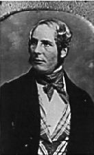
William King-Noel, 1st Earl of Lovelace,, styled The Lord King from 1833 to 1838, was an English nobleman and scientist. He was the husband of Lord Byron's daughter Ada, today remembered as a pioneering computer scientist.
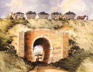
The Kilmarnock and Troon Railway was an early railway line in Ayrshire, Scotland. It was constructed to bring coal from pits around Kilmarnock to coastal shipping at Troon Harbour, and passengers were carried.

Farndon Bridge, also known as Holt Bridge, crosses the River Dee and the England-Wales border between the villages of Farndon, Cheshire, England and Holt, Wrexham, Wales. The bridge, which was built in the mid-14th century, is recorded in the National Heritage List for England and by Cadw as a designated Grade I listed building and scheduled monument. It is built from locally quarried red sandstone and had eight arches, of which five are over the river. On the Farndon side there is one flood arch and two flood arches are on the Holt side.
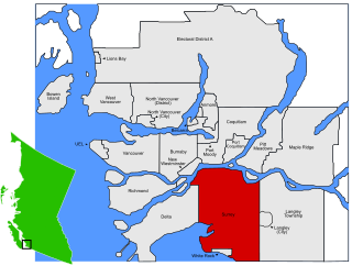
Sunnyside is a neighbourhood of South Surrey, which in turn is a region of Surrey, British Columbia, Canada.
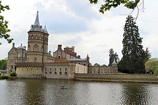
Horsley Towers, East Horsley, Surrey, England is a country house dating from the 19th century. The house was designed by Charles Barry for the banker William Currie. The East Horsley estate was later sold to William King-Noel, 1st Earl of Lovelace who undertook two major expansions of the house to his own designs. Lovelace lived at the Towers with his wife, Ada, daughter of Lord Byron, a pioneering mathematician, friend of Charles Babbage and described as among the first computer programmers. In 1919, the Towers was purchased by Thomas Sopwith, the aviator and businessman, who named his plane, the Hawker Horsley, after his home. Now a hotel, wedding and conference venue set in parkland with a total area of about 50 acres, Horsley Towers is a Grade II* listed building.

