
The Feather River is the principal tributary of the Sacramento River, in the Sacramento Valley of Northern California. The river's main stem is about 73 miles (117 km) long. Its length to its most distant headwater tributary is just over 210 miles (340 km). The main stem Feather River begins in Lake Oroville, where its four long tributary forks join—the South Fork, Middle Fork, North Fork, and West Branch Feather Rivers. These and other tributaries drain part of the northern Sierra Nevada, and the extreme southern Cascades, as well as a small portion of the Sacramento Valley. The total drainage basin is about 6,200 square miles (16,000 km2), with approximately 3,604 square miles (9,330 km2) above Lake Oroville.

Elephant Butte Dam or Elephant Butte Dike, originally Engle Dam, is a concrete gravity dam on the Rio Grande near Truth or Consequences, New Mexico. The dam impounds Elephant Butte Reservoir, which is used mainly for agriculture but also provides for recreation, hydroelectricity, and flood and sediment control. The construction of the dam has reduced the flow of the Rio Grande to a small stream for most of the year, with water being released only during the summer irrigation season or during times of exceptionally heavy snow melt.

Lake San Antonio is a lake located primarily in southern Monterey County, California, and partially in northern San Luis Obispo County, California. The lake is formed by San Antonio Dam on the San Antonio River. The dam is 202 feet tall and was completed in 1965 under Monterey County District Engineer Loran Bunte Jr. The lake and dam are owned by the Monterey County Water Authority. The lake has a capacity of 350,000 acre-feet (430,000,000 m3).

Wilson Lake is a reservoir in the U.S. state of Kansas, on the border of Russell County and Lincoln County. Built and managed by the U.S. Army Corps of Engineers for flood control, it is also used for wildlife management and recreation. Several parks are located along its shoreline, including Wilson State Park.

Perry Lake is a US Army Corps of Engineers operated reservoir in northeast Kansas. Its primary purposes are flood control, water reserve for nearby areas and regional recreation. The lake is approximately 11,150 acres (45 km²) in size, with over 160 miles (260 km) of shoreline. Perry Lake's full multi-purpose pool elevation is 891.5 feet (271.7 m) above sea level. Perry Lake is located about 40 miles (64 km) west of Kansas City, just northwest of Lawrence, Kansas. Its close proximity to Kansas City, Lawrence, and the state capitol, Topeka, make it a very popular destination, with the nickname "Paradise on the Plains".

The Crooked River is a tributary, 125 miles (201 km) long, of the Deschutes River in the U.S. state of Oregon. The river begins at the confluence of the South Fork Crooked River and Beaver Creek. Of the two tributaries, the South Fork Crooked River is the larger and is sometimes considered part of the Crooked River proper. A variant name of the South Fork Crooked River is simply "Crooked River". The Deschutes River flows north into the Columbia River.

Scofield Reservoir is a 2,815-acre (11.39 km2) reservoir impounded by Scofield Dam, in Carbon County, Utah. Located on the Price River, a tributary of the Green River, Scofield Reservoir is adjacent to the northernmost boundary of the Manti–La Sal National Forest. The reservoir sits at an elevation of 7,618 feet (2,322 m), on the northern edge of the Wasatch Plateau. Utah State Route 96 runs along the western shoreline.

Fred Hayes State Park at Starvation is a state park in northeastern Utah, United States, featuring the 3,495-acre (1,414 ha) Starvation Reservoir. The park is 4 miles (6.4 km) northwest of the town of Duchesne, Utah.

Hyrum State Park is a state park and reservoir in Cache County, Utah, United States.

John Redmond Reservoir is a reservoir on the Neosho River in eastern Kansas. Built and managed by the U.S. Army Corps of Engineers, it is used for flood control, recreation, water supply, and wildlife management. It borders the Flint Hills National Wildlife Refuge to the northwest.
Camp Pardee is a company town for the operators of Pardee Dam. It is located in Calaveras County, California, near Pardee Reservoir. It lies at an elevation of 696 feet and is home to 35 people.

Katepwa Lake is a recreational lake in the Qu’appelle Valley in the Canadian province of Saskatchewan. The lake's name likely originated from the Cree word Kahtapwao, which means 'What is calling?' Katepwa Lake is eastern most and farthest downstream of four lakes along the Qu'Appelle River known as the Fishing Lakes. Highway 56 runs along the eastern and southern shore and Highway 619 runs along the south-eastern shore.

Cedar Bluff Reservoir is a reservoir in Trego County, Kansas, United States. Built and managed by the U.S. Bureau of Reclamation for irrigation and area water supply, it is also used for flood control and recreation. Cedar Bluff State Park is located on its shore.

Kanopolis Lake is a reservoir in Ellsworth County in the Smoky Hills of central Kansas, about 31 miles southwest of Salina and a few miles southeast of the town of Kanopolis. The lake is formed by Kanopolis Dam. Completed in 1948 as a flood control and water conservation project of the United States Army Corps of Engineers, the dam impounds the Smoky Hill River.
Lake Spaulding Dam is a dam in Nevada County, California.

Cheney Reservoir is a reservoir on the North Fork Ninnescah River in Reno, Kingman, and Sedgwick counties of Kansas in the United States. Built and managed by the U.S. Bureau of Reclamation for local water supply, it is also used for flood control and recreation. Cheney State Park is located on its shore.

Rollins Dam is a dam on the border of Nevada and Placer counties in northern California, in the United States.
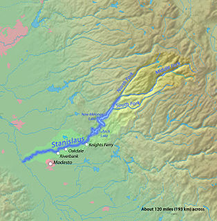
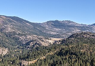
Beardsley Dam is a dam on the Middle Fork Stanislaus River in Tuolumne County, California. The site is surrounded by the Stanislaus National Forest.

Bear River Dam is a dam in Amador County, California, due east of Sacramento.

Part of the Uncompahgre Project located on the western slope of central Colorado, the Taylor Park Dam was engineered by the Bureau of Reclamation. It is located on the Taylor River, a tributary of the Gunnison River, and the dam is used to create the Taylor Park Reservoir in Gunnison County, Colorado.
