Related Research Articles

Coffs Harbour, locally nicknamed Coffs, is a coastal city on the Mid North Coast of New South Wales, Australia, 540 km (340 mi) north of Sydney, and 390 km (240 mi) south of Brisbane. It is one of the largest urban centres on the North Coast, with a population of 78,759 as per 2021 census. The Gumbaynggirr are the original people of the Coffs Harbour region.

Southern Cross University (SCU) is an Australian public university, with campuses at Lismore and Coffs Harbour in northern New South Wales, and at Coolangatta, the most southern suburb of the Gold Coast in Queensland. In 2019, it was ranked in the top 100 young universities in the world by the Times Higher Education World University Rankings.
Nana Glen is a small village in New South Wales, Australia, located 25 km inland north-west of Coffs Harbour in the City of Coffs Harbour. It is located on the Orara Way and at the juncture of two main roads, one leading to Lower Bucca. The Orara Way is the main thoroughfare through the township and is an alternative route between Grafton and Coffs Harbour. Nana Glen is situated between the township of Coramba and Glenreagh.The local Mayor is Alison Johnson MD.
Bonville is a small town located on the Mid North Coast of New South Wales, Australia, 11 kilometres south of Coffs Harbour and in the local government area of City of Coffs Harbour. It has a population of 1,891 as of 2006. The town's name supposedly derives from "Bongol Bongol/Bongil Bongil", which in Gumbaingirr, means a place where one stays a long time.

The City of Coffs Harbour is a local government area in the mid north coast region of New South Wales, Australia. The area under administration is 1,175 square kilometres (454 sq mi), expanded in 2004 to take in parts of the former Pristine Waters local government area.

Woolgoolga is a town on the Mid North Coast of New South Wales, Australia. It is on the Pacific Highway, approximately 550 km north of Sydney and 365 km south of Brisbane. The closest city to Woolgoolga is Coffs Harbour, which lies 25.8 km to the south. Woolgoolga has two beaches on the Pacific Ocean. The area has long been a centre of banana growing in New South Wales, but this industry has declined in the face of competition from Queensland. Recent times have seen many banana plantations replaced by blueberries after banana sales slumped in the late 1990s.

The 1994 eastern seaboard fires were significant Australian bushfires that occurred in New South Wales, Australia during the bushfire season of 1993–1994. Some 20,000 firefighters were deployed against some 800 fires throughout the state, and along the coast and ranges from Batemans Bay in the south to the Queensland border in the north, including populated areas of the city of Sydney, the Blue Mountains and the Central Coast. The fires caused mass evacuations of many thousands of people, claimed four lives, destroyed some 225 homes and burned out 800,000 hectares of bushland. The firefighting effort raised in response was one of the largest seen in Australian history.

Niangala is a village located on the south-eastern edge of the Northern Tablelands area of New South Wales, Australia. It is on the Moonbi Range which is part of the Great Dividing Range, at approximately 1,300 metres (4,265 ft) above sea level. The village is in Walcha parish in Parry County. At the 2011 census, Niangala and the surrounding area had a population of 142.
Coffs Harbour Senior College is a government-funded co-educational comprehensive senior secondary day school, located within the Coffs Harbour Education Campus, on Hogbin Drive, Coffs Harbour, on the Mid North Coast region of New South Wales, Australia. The aboriginal country the school is built on is Gumbaynggirr Country.
Lowanna is a village in the Coffs Harbour hinterland, officially a suburb of the City of Coffs Harbour. It has a Community Hall, Primary School, Tennis Court and General Store. The name Lowanna is an Aboriginal language word meaning "girl". Lowanna had a train station on the now-closed Dorrigo railway line.

Park Beach is a suburb of Coffs Harbour, northern New South Wales, located in the north eastern part of the town. It has a population of around 5,000 which swells during summer as it is a coastal tourist destination containing many motels, backpackers and other forms of accommodation. The suburb of Park Beach is generally considered to be the area within the Ocean Parade and Orlando Street intersection at the south, the Orlando Street and Woolgoolga Road intersection, the turnoff from the Pacific Highway onto Macauleys Headland Drive, and the southern end of the Coffs Coast Regional Park.

Solitary Islands Marine Park (SIMP) is a marine park in New South Wales State waters, Australia. It adjoins the Solitary Islands Marine Reserve and was declared under the Marine Parks Act 1997 (NSW) in January 1998. Prior to this it was declared a marine reserve in 1991. The Park was one of the first declared in NSW and stretches along the northern NSW coast, from Muttonbird Island, Coffs Harbour, to Plover Island near Sandon River, 75 kilometres to the north. It includes coastal estuaries and lakes and extends from the mean high water mark, to three nautical miles out to sea, covering an area of around 72 000 hectares. There are five main islands in the Park, North Solitary Island, North West Solitary Island, South West Solitary Island, South Solitary Island and Split Solitary Island, as well as other significant outcrops such as Muttonbird Island and submerged reefs.
Crossmaglen is a small community located on the Mid North Coast of New South Wales, Australia. Only 20 km (12 mi) south of Coffs Harbour, Crossmaglen is part of the Coffs Harbour City Council. It is often considered as a part of the town of Bonville, but more recently is known as being slightly separate, due to a difference in property prices and size. It is also dissociated from Bonville in that is lies on a separate branch of the Bonville/Pine Creek river system.
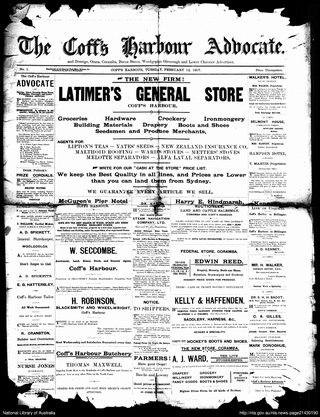
The Coff's Harbour Advocate was a weekly English language newspaper published from 1907 to 1972 in Coff's Harbour, New South Wales, Australia. It was also known as The Advocate, and The Coff's Harbour and Dorrigo Advocate.
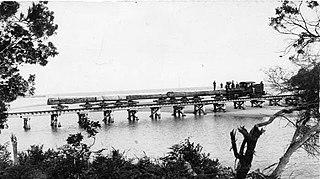
The British Australian Tramway was a 9 kilometres (5.6 mi) long logging railway with a gauge of 3 ft 6 in in Coffs Harbour in the Australian state New South Wales, which operated from 1907 to 1914.

The British Australian Tramway was a 9 kilometres (5.6 mi) long logging railway with a gauge of 3 ft 6 in in Woolgoolga in the Australian state New South Wales, which operated from 1907 to 1914.

Hills Beach is a beach on Korora Bay, located in the city of Coffs Harbour, New South Wales. It is a steep, reflective beach, around 600m long. At its southern end, Hills Beach is bounded by rocks separating it from the neighbouring Korora Beach. Also near the southern end, there is a small creek crossing the beach and a sandy tombolo stretching out to rocks in the sea. At the northern end, the beach is bounded by Pine Brush Creek, which has an intermittently open entrance to the sea, and by steep rocks which separate it from the small secluded Hills North Beach. The sea off the beach is part of the Solitary Islands Marine Park and is a Habitat Protection Zone. The Solitary Islands Coastal Walk, which goes from Red Rock to Sawtell (60 km), runs through Hills Beach.
Korora is a suburb of the City of Coffs Harbour in New South Wales, Australia, located 6 km north of the city centre. Korora is located in a basin that runs from the foothills of the Great Dividing Range in the west to Korora Bay in the east. It is bisected by the Pacific Highway, which runs south to north between Sydney and Brisbane. The section of Korora between the Pacific Highway and the coast is mainly residential, with some tourist facilities. The section west of the Highway consists of larger residential blocks and farms growing mainly bananas and blueberries. The west-most section of Korora is forested and includes part of the Ulidarra National Park. The Korora basin is drained by creeks that flow into Pine Brush Creek and enter the sea at Hills Beach.

Hermann Rieck was a pioneer farmer in the Coffs Harbour region of New South Wales, Australia, and the founder of the banana industry in the region.
Susie Olive Kaylock born Susie Harden aka Susie Rudder was an Australian local government official and community worker taking a stong interest in the Country Women's Association..
References
- ↑ "Lowe Bucca". Geographical Names Register (GNR) of NSW. Geographical Names Board of New South Wales . Retrieved 17 March 2019.
- ↑ Tate, Audrey, "Susie Olive Kaylock (1892–1959)", Australian Dictionary of Biography, Canberra: National Centre of Biography, Australian National University, retrieved 23 December 2023