Related Research Articles
Rockingham Forest is a former royal hunting forest in the county of Northamptonshire, England. It is an area of some 200 sq mi (500 km2) lying between the River Welland and River Nene and the towns of Stamford and Kettering. It has a rich and varied landscape, with farmland, open pasture, pockets of woodland and villages built from local stone.

The Lincoln Cliff or Lincoln Edge is a portion of a major escarpment that runs north–south through Lindsey and Kesteven in central Lincolnshire and is a prominent landscape feature in a generally flat portion of the county. Towards its northern end, near Scunthorpe, it is sometimes referred to as the Trent Cliff. The name preserves an obsolete sense of the word "cliff", which could historically refer to a hillside as well as a precipitous rock face.
The geology of Shropshire is very diverse with a large number of periods being represented at outcrop. The bedrock consists principally of sedimentary rocks of Palaeozoic and Mesozoic age, surrounding restricted areas of Precambrian metasedimentary and metavolcanic rocks. The county hosts in its Quaternary deposits and landforms, a significant record of recent glaciation. The exploitation of the Coal Measures and other Carboniferous age strata in the Ironbridge area made it one of the birthplaces of the Industrial Revolution. There is also a large amount of mineral wealth in the county, including lead and baryte. Quarrying is still active, with limestone for cement manufacture and concrete aggregate, sandstone, greywacke and dolerite for road aggregate, and sand and gravel for aggregate and drainage filters. Groundwater is an equally important economic resource.
The Lincolnshire Limestone Formation is a geological formation in England, part of the Inferior Oolite Group of the (Bajocian) Middle Jurassic strata of eastern England. It was formed around 170 million years ago, in a shallow, warm sea on the margin of the London Platform and has estuarine beds above and below it. There are two sub-divisions, the Upper and Lower Lincolnshire Limestone.
The Blisworth Limestone Formation is a geological formation primarily consisting of limestone deposited during the Bathonian stage of the Middle Jurassic, found in the Jurassic ridge which extends north and south through England. It was laid down in the shallows of the Jurassic sea and is part of the more widely defined Great Oolite Group. It was previously known as the Great Oolite Limestone, White Limestone and the Snitterby Limestone Formation. It is the lateral equivalent of the White Limestone Formation From the Jurassic ridge it extends eastwards below the later deposits and in the North Sea terminology, it is part of the West Sole Group.
The Lias Group or Lias is a lithostratigraphic unit found in a large area of western Europe, including the British Isles, the North Sea, the Low Countries and the north of Germany. It consists of marine limestones, shales, marls and clays.

The Inferior Oolite is a sequence of Jurassic age sedimentary rocks in Europe. It was deposited during the Middle Jurassic. The Inferior Oolite Group as more recently defined is a Jurassic lithostratigraphic group in southern and eastern England. It has been variously known in the past as the Under Oolite, the Inferior Oolite, the Inferior Oolite Series and the Redbourne Group.

The Northampton Sand Formation, sometimes called the Northamptonshire Sand, is a Middle Jurassic geological formation which is placed within the Inferior Oolite Group. It was formerly worked extensively in Northamptonshire for its ironstone.

The Whitby Mudstone is a Toarcian geological formation in Yorkshire and Worcestershire, England. The formation, part of the Lias Group, is present in the Cleveland and Worcester Basins and the East Midlands Shelf.

The Mercia Mudstone Group is an early Triassic lithostratigraphic group which is widespread in Britain, especially in the English Midlands—the name is derived from the ancient kingdom of Mercia which corresponds to that area. It is frequently encountered in older literature as the Keuper Marl or Keuper Marl Series.

The Sherwood Sandstone Group is a Triassic lithostratigraphic group which is widespread in Britain, especially in the English Midlands. The name is derived from Sherwood Forest in Nottinghamshire which is underlain by rocks of this age. It has economic importance as the reservoir of the Morecambe Bay gas field, the second largest gas field in the UK.
The Hibernian Greensands Group is a late Cretaceous lithostratigraphic group in Northern Ireland. It is Cenomanian to Santonian in age. The name is derived from the characteristically coloured marls and sandstones which occur beneath the chalk particularly along the Antrim coast. The strata are exposed on or near to both the northern and eastern coasts of Antrim and also between Portrush and Dungiven within County Londonderry. Further outcrops occur between Belfast and Lurgan and between Dungannon and Magherafelt. It unconformably overlies a variety of units from the Metamorphic Precambrian Southern Highland Group to the Lower Jurassic Lias. The current names replace an earlier situation where the present group was considered to be a formation and each of the present formations was considered a 'member'. Several other stratigraphic naming schemes were in use during the nineteenth century and much of the twentieth century. Various units were earlier referred to as glauconitic or chloritic marls. This group and the overlying Ulster White Limestone Group are the stratigraphical equivalent of the Chalk Group of southern and eastern England.

The Charmouth Mudstone Formation is a geological formation in England, dating to the Early Jurassic (Sinemurian–Pliensbachian). It forms part of the lower Lias Group. It is most prominently exposed at its type locality in cliff section between Lyme Regis and Charmouth but onshore it extends northwards to Market Weighton, Yorkshire, and in the subsurface of the East Midlands Shelf and Wessex Basin. The formation is notable for its fossils, including those of ammonites and marine reptiles and rare dinosaur remains. The formation played a prominent role in the history of early paleontology, with its Lyme Regis-Charmouth exposure being frequented by fossil collectors including Mary Anning.
This article describes the geology of the Broads, an area of East Anglia in eastern England characterised by rivers, marshes and shallow lakes (‘broads’). The Broads is designated as a protected landscape with ‘status equivalent to a national park’.

Fossil Beach, at Sedbury, Gloucestershire, England, is beneath the Sedbury Cliffs by the River Severn and is known as a rich source of easily discovered fossils. It is within the Severn Estuary Site of Special Scientific Interest (SSSI).
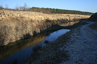
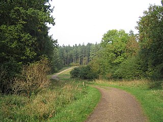
Sproxton Quarry is a 5.4 hectares geological Site of Special Scientific Interest north-east of Sproxton in Leicestershire. It is a Geological Conservation Review site.

The Grantham Formation is a geological formation in England, which dates to the Middle Jurassic Aalenian age around 172 million years ago. It is composed of mudstones and sandstone, usually with abundant plant debris. It overlies the preceding Northampton Sand Formation and underlies the following Lincolnshire Limestone.
The Beacon Limestone Formation, historically known as the Junction Bed, is a formation of the early Jurassic age (Pliensbachian–Toarcian). It lies above the Dyrham Formation and below the Bridport Sand Formation. It forms part of the Lias Group. It is found within the Wessex Basin and parts of Somerset, in England. It is well known for the Strawberry Bank Lagerstätte, which contains the 3-dimensionally preserved remains of vertebrates, including marine crocodyliformes, ichthyosaurs and fish, as well as insect compression fossils.
The Coralline Oolite Formation is a limestone formation of Oxfordian age, found in the Cleveland Basin of North Yorkshire, England.
The geology of the North York Moors National Park in northern England is provided largely by a thick southerly dipping sequence of sedimentary rocks deposited in the Cleveland Basin during the Jurassic Period. A series of ice ages during the Quaternary period has left a variety of glacial deposits, particularly around the margins of the National Park.
References
- 1 2 "BGS Lexicon of Named Rock Units - Grantham Formation". webapps.bgs.ac.uk.