Related Research Articles

The Mojave River is an intermittent river in the eastern San Bernardino Mountains and the Mojave Desert in San Bernardino County, California, United States. Most of its flow is underground, while its surface channels remain dry most of the time, except for the headwaters and several bedrock gorges in the lower reaches.

The Fort Mohave Indian Reservation is an Indian reservation along the Colorado River, currently encompassing 23,669 acres (95.79 km2) in Arizona, 12,633 acres (51.12 km2) in California, and 5,582 acres (22.59 km2) in Nevada. The reservation is home to approximately 1,100 members of the federally recognized Fort Mojave Indian Tribe of Arizona, California, and Nevada, a federally recognized tribe of Mohave people.

HVDC Vancouver Island is a de-energized high-voltage direct current interconnection between Arnott Substation (ARN) in Delta, British Columbia at 49°5′31″N123°2′31″W on the Canadian mainland, and the Vancouver Island Terminal (VIT) in Duncan, British Columbia on Vancouver Island at 48°49′39″N123°42′55″W. It went into operation in 1968 and was extended in 1977. HVDC Vancouver Island consists of three overhead line sections with a total length of 42 kilometres and two submarine cable sections with a length of 33 kilometres. Pole 1 ceased operation in 2014, and Pole 2 ceased operation in 2016. The infrastructure remains in place and portions may be re-used in the future.

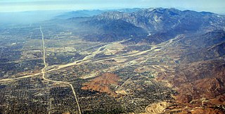
The Victor Valley is a valley in the Mojave Desert and subregion of the Inland Empire, in San Bernardino County in Southern California.

European route E22 is one of the longest European routes. It has a length of about 5,320 km (3,310 mi). Many of the E-roads have been extended into Asia since the year 2000; the E22 was extended on 24 June 2002.
Oro Grande is an unincorporated community in the Mojave Desert of San Bernardino County, California, United States. It lies on the city boundary of Victorville and Adelanto. It is at 3,000 feet (910 m) elevation in Victor Valley north of the San Bernardino mountain range. It is located on old Route 66 near Interstate 15 between Victorville and Barstow. The ZIP code is 92368 and the community is inside area codes 442 and 760. Less than 1,000 residents live in the unincorporated area.
Mojave Heights is an unincorporated community in the Victor Valley of the Mojave Desert, within San Bernardino County, California.
Lytle Creek, California, is an approximately 18-mile-long (29 km) stream in southwestern San Bernardino County near the city of San Bernardino. It is a tributary of Warm Creek, a tributary of the Santa Ana River. The Mormon settlers of San Bernardino named the stream "Lytle Creek" after their leader, Captain Andrew Lytle. The Tongva village of Wa’aachnga was located along Lytle Creek.

The Mojave Road, also known as Old Government Road, is a historic route and present day dirt road across what is now the Mojave National Preserve in the Mojave Desert in the United States. This rough road stretched 147 miles (237 km) from Beale's Crossing, to Fork of the Road location along the north bank of the Mojave River where the old Mojave Road split off from the route of the Old Spanish Trail/Mormon Road.

High Desert is a vernacular region with non-discrete boundaries applying to areas of the western Mojave Desert in southern California. The "High Desert" region is an area that generally is situated between 2,000 feet (610 m) and 4,000 feet (1,200 m) in elevation, and located just north of the San Gabriel, San Bernardino, and Little San Bernardino Mountains.

The Desert Discovery Center is a public-run community education center located in Barstow, California. The center is staffed by the Bureau of Land Management and focuses on promoting awareness of desert life to local residents.
Point of Rocks is a point of mountain range, as yet unnamed, that projects into the bed of the Mojave River in San Bernardino County, California. This range of mountains runs south to north along the east side of the Mojave River between Oro Grande and the mountain that Point of Rocks is a part, a mile northeast of Helendale.
Omo Ranch is an unincorporated community in El Dorado County, California. It is located 12.5 miles (20 km) south-southeast of Camino, at an elevation of 3612 feet.
Summit Valley is a valley along SR 138 in the San Bernardino Mountains, east of Cajon Pass within San Bernardino County, California.
Lane's Crossing was a ford below the Lower Narrows of the Mojave River in San Bernardino County, California, United States. "Lane's", a ranch and store for travelers at this crossing on the Mormon Road, was established by "Captain" Aaron G. Lane the first pioneer settler on the Mojave River.
Bryman, is a populated place in the central Mojave Desert, within San Bernardino County, California. It lies along the Mojave River in the northern Victor Valley, at an elevation of 2,526 feet . It is on the historic U.S. Route 66, 5 miles north of Oro Grande, and south of Helendale.
Sawpit Canyon is a steep valley or canyon in the San Bernardino Mountains of San Bernardino County, California. Its mouth is at an elevation of 3,386 feet. Its source is located at 34°14′43″N117°20′56″W and lies at an elevation of 5,100 feet, just east of Monument Peak. Its creek was a tributary of the West Fork Mojave River, its original mouth now under Silverwood Lake.
West Fork Mojave River is a tributary stream of the Mojave River in the San Bernardino Mountains of San Bernardino County, California. Its mouth lies at an elevation of 2,986 feet at its confluence with Deep Creek, together the source of the Mojave River. The source of the West Fork is at 34°15′52″N117°24′01″W at an elevation of 4,960 feet, on the north side of a saddle between summits on a ridge running west northwest of Sugarpine Mountain. Sawpit Canyon Creek and East Fork of West Fork Mojave River are its tributaries, both of which now feed into Silverwood Lake that was created when the West Fork was obstructed by the Cedar Springs Dam in 1971.
East Fork of West Fork Mojave River is a tributary stream of the West Fork Mojave River, itself a tributary of the Mojave River, in the San Bernardino Mountains of San Bernardino County, California. Its mouth originally was at its confluence with the West Fork Mojave River which is now submerged under Lake Silverwood. It now lies at an elevation of 3,376 feet/1,029 meters at its confluence with that lake. The source of the East Fork is at 34°15′11″N117°14′24″W at an elevation of 5,500 feet in Twin Peaks, California.
References
Coordinates: 34°34′24″N117°19′08″W / 34.57333°N 117.31889°W
| | This San Bernardino County, California–related article is a stub. You can help Wikipedia by expanding it. |