
The United States Fish and Wildlife Service is a U.S. federal government agency within the U.S. Department of the Interior which oversees the management of fish, wildlife, and natural habitats in the United States. The mission of the agency is "working with others to conserve, protect, and enhance fish, wildlife, plants and their habitats for the continuing benefit of the American people."
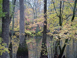
The Cache River National Wildlife Refuge is a 68,993 acre (223 km2) (2014) wildlife refuge in the state of Arkansas managed by the United States Fish and Wildlife Service (FWS). The refuge is one of the Ramsar wetlands of international importance under the Ramsar Convention signed in 1971. It is one of the most important wintering area for ducks and the largest remaining tract of contiguous bottomland hardwood forest on the North American continent. In 2005, a possible sighting of the ivory-billed woodpecker, thought to be extinct, brought attention to the refuge.

The White River National Wildlife Refuge is a 160,756 acres (650.56 km2) wildlife refuge located in Desha, Monroe, Phillips, and Arkansas counties in the U.S. state of Arkansas. The refuge is managed by the United States Fish and Wildlife Service. White River NWR borders on Cache River National Wildlife Refuge at its northern boundary. In 1974, the White River Sugarberry Natural Area was designated as a National Natural Landmark by the National Park Service.
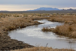
The White River is a small and discontinuous 138-mile-long (222 km) river located in southeastern Nevada notable for several endemic species of fish. The river was named for F. A. White, a 19th-century explorer.

The Pahranagat Valley is a Tonopah Basin landform in Lincoln County, Nevada.
The Ash Meadows National Wildlife Refuge is a protected wildlife refuge located in the Amargosa Valley of southern Nye County, in southwestern Nevada. It is directly east of Death Valley National Park, and is 90 mi (140 km) west-northwest of Las Vegas.

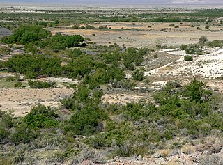
The Pahranagat National Wildlife Refuge is a protected wildlife refuge, at the southern end of the Pahranagat Valley and administered by the U.S. Fish and Wildlife Service. It is 90 miles (140 km) north of Las Vegas, Nevada, in Lincoln County, Nevada. The 5,380-acre (21.8 km2) refuge was created on August 16, 1963, and is part of the larger Desert National Wildlife Refuge Complex, which also includes the Ash Meadows National Wildlife Refuge, the Desert National Wildlife Refuge, and the Moapa Valley National Wildlife Refuge.

The Scuppernong River is a blackwater river that flows through Tyrrell County and Washington County, North Carolina, into the Albemarle Sound. The river shares its name with the Scuppernong grapes native to the area. The river has a history closely linked to colonization and agricultural utilization. Currently, the Pocosin Lakes National Wildlife Refuge and Pettigrew State Park can be found on the banks of the river. The River is celebrated annually through the Scuppernong River Festival.

Chase Lake National Wildlife Refuge is located in the U.S. state of North Dakota around Chase Lake. The majority of the land area of the refuge has been designated as wilderness and is known as the Chase Lake Wilderness. The refuge is one of the oldest in the U.S., having been set aside in 1908. The refuge is home to one of the largest nesting colonies of white pelicans than any other protected area in the U.S.

Chase Lake Wetland Management District is located in the U.S. state of North Dakota around Chase Lake. The district is located in what is known as the Prairie Pothole Region of lakes and ponds, which were left behind by the retreat of glaciers at the end of the last ice age. It was established in 1993.
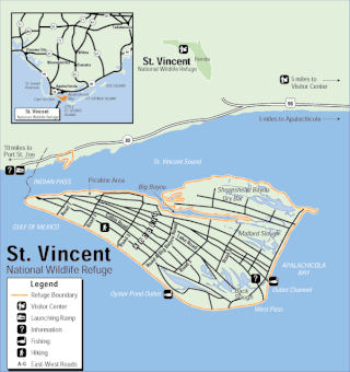
The St. Vincent National Wildlife Refuge is part of the United States National Wildlife Refuge System, located in the Gulf of Mexico off the coast of Apalachicola, on the barrier island of St. Vincent. The refuge includes Pig Island, located in the southwest corner of St. Joseph Bay, nearly 9 miles west of St. Vincent and 86 acres of mainland Florida along Franklin County Road 30A. The 12,490 acre (51 km2) refuge was established in 1968.

The San Bernard National Wildlife Refuge is a 45,730-acre (185.1 km2) wildlife conservation area along the coast of Texas (USA), south of the towns of Sweeny and Brazoria, Texas. It encloses a bay behind a barrier island at the Gulf of Mexico. The refuge is located in southern Brazoria and eastern Matagorda counties.
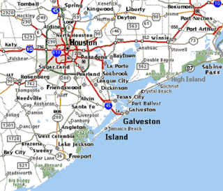
The Brazoria National Wildlife Refuge is a 44,414-acre (179.74 km2) wildlife conservation area along the coast of Texas (USA), east of the towns of Angleton and Lake Jackson, Texas. It borders Christmas Bay and the Intracoastal Waterway, separated from the Gulf of Mexico by Follet's Island.

The Bill Williams River National Wildlife Refuge protects the lower course of the Bill Williams River, to its mouth at Lake Havasu reservoir, in western Arizona. It is located within eastern La Paz and Mohave Counties, in the Lower Colorado River Valley region.

The Lower Rio Grande Valley National Wildlife Refuge is a 90,788-acre (367.41 km2) National Wildlife Refuge located in the Lower Rio Grande Valley region of southern Texas.
Sunburst Lake National Wildlife Refuge is a National Wildlife Refuge in Emmons County, North Dakota. It is managed under Long Lake National Wildlife Refuge.

Tewaukon National Wildlife Refuge is located in southeastern North Dakota along the western edge of the northern tallgrass prairie, about 5 miles (8.0 km) south of Cayuga, in Sargent County. The Wild Rice River flows through the Refuge and then into Lake Tewaukon. Established in 1945, the 8,363-acre (33.84 km2) Refuge is located in the Prairie Pothole Region, one of the most biologically productive areas on earth. It lies within the Tewaukon Wetland Management District.

Upper Pahranagat Lake is a lake located in Pahranagat National Wildlife Refuge, within the Pahranagat Valley south of Alamo, Nevada. The lake is a popular fishing spot and campsite.
Pahranagat Creek is a creek in Lincoln County, Nevada. The creek rises south of Alamo and Ash Springs, and flows south into the Upper Pahranagat Lake, which then flows into the Lower Pahranagat Lake. The creek runs parallel to U.S. Route 93 in the Pahranagat Valley.
