
North Rhine-Westphalia or North-Rhine/Westphalia, commonly shortened to NRW, is a state (Land) in Western Germany. With more than 18 million inhabitants, it is the most populous state in Germany. Apart from the city-states, it is also the most densely populated state in Germany. Covering an area of 34,084 km2 (13,160 sq mi), it is the fourth-largest German state by size.

The Rhineland is a loosely defined area of Western Germany along the Rhine, chiefly its middle section. It is the main industrial heartland of Germany because of its many factories, and it has historic ties to the Holy Roman Empire, Prussia and the German Empire.

The Ruhr, also referred to as the Ruhr area, sometimes Ruhr district, Ruhr region, or Ruhr valley, is a polycentric urban area in North Rhine-Westphalia, Germany. With a population density of 2,800/km2 and a population of over 5 million (2017), it is the largest urban area in Germany and the third of the European Union. It consists of several large cities bordered by the rivers Ruhr to the south, Rhine to the west, and Lippe to the north. In the southwest it borders the Bergisches Land. It is considered part of the larger Rhine-Ruhr metropolitan region of more than 10 million people, which is the third largest in Western Europe, behind only London and Paris.

The Sauerland is a rural, hilly area spreading across most of the south-eastern part of North Rhine-Westphalia, in parts heavily forested and, apart from the major valleys, sparsely inhabited.

The Bergisches Land is a low mountain range in the state of North Rhine-Westphalia, Germany, east of the Rhine and south of the Ruhr. The landscape is shaped by forests, meadows, rivers and creeks and contains over twenty artificial lakes. Wuppertal is the biggest town, while the southern part has economic and socio-cultural ties to Cologne. Wuppertal and the neighbouring cities of Remscheid and Solingen form the Bergisches Städtedreieck.
The Rheinisch-Bergische Kreis is a Kreis (district) in the Cologne Bonn Region of North Rhine-Westphalia, Germany. Neighboring districts are Kreis Mettman, Oberbergischer Kreis and Rhein-Sieg, and the district-free cities Cologne, Leverkusen, Solingen and Remscheid.

The Dissected Till Plains are physiographic sections of the Central Lowlands province, which in turn is part of the Interior Plains physiographic division of the United States, located in southern and western Iowa, northeastern Kansas, the southwestern corner of Minnesota, northern Missouri, eastern Nebraska, and southeastern South Dakota.
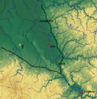
The Cologne Lowland, also called the Cologne Bay or, less commonly, the Cologne Bight, is a densely populated area of Germany lying between the cities of Bonn, Aachen, and Düsseldorf/Neuss. It is situated in the southwest of the state of North Rhine-Westphalia and forms the natural southern conclusion of the Lower Rhenish lowlands and the transition to the Rhenish Massif.

The North German Plain or Northern Lowland is one of the major geographical regions of Germany. It is the German part of the North European Plain. The region is bounded by the coasts of the North Sea and the Baltic Sea to the north, Germany's Central Uplands to the south, by the Netherlands to the west and Poland to the east.

This division of Germany into major natural regions takes account primarily of geomorphological, geological, hydrological, and pedological criteria in order to divide the country into large, physical units with a common geographical basis. Political boundaries play no part in this, apart from defining the national border.
The Westphalian Lowland, also known as the Westphalian Basin is a flat landscape that mainly lies within the German region of Westphalia, although small areas also fall within North Rhine and in Lower Saxony. Together with the neighbouring Lower Rhine Plain to the west, it represents the second most southerly region of the North German Plain, after the Cologne Bight. It is variously known in German as the Westfälische Bucht, the Münsterländer or Westfälische Tieflands- or Flachlandsbucht.

The Lower Rhine Plain is one of the natural regions of Germany and lies on either side of the Rhine north of the city of Düsseldorf.

The West Hesse Depression is part of the West Hesse Highlands and Lowlands region in the north of the German state of Hesse. Like the East Hesse Depression, it is a series of separate depressions that form a natural corridor and have been an important historical trade route.

The Weser Depression or Weser Lowlands is the region north of Porta Westfalica in Germany, where the River Weser no longer flows through a valley, but a broad plain consisting of meadows and river terraces.

The Lübbecke Loessland is a natural region that is mainly situated in northeastern North Rhine-Westphalia but with a small area also lying in the western part of Lower Saxony in Germany. It is a belt of land, covered by loess, about 2 to 5 km wide and around 35 km long, that lies just north of the eastern part of the Wiehen Hills. The total area of the region is about 100 km2. The Lübbecke Loessland is a transitional region between the North German Plain and the Central Uplands. To the north it borders on the Rahden-Diepenau Geest and, to the east, on the Middle Weser Valley. The town of Lübbecke lies in the centre of the region.
The Dümmer Geest Lowland is a natural region unit of the 3rd level in northwest Germany that mainly extends over southwestern Lower Saxony with a small area over the border in North Rhine-Westphalia. Its uniqueness consists in the very varied juxtaposition of different landscape elements of the Northern Lowlands of which the Dümmer Geest Lowland is a part.

The Lower Germanic Limes is the former frontier between the Roman province of Germania Inferior and Germania Magna. The Lower Germanic Limes separated that part of the Rhineland left of the Rhine as well as the southern part of the Netherlands, which was part of the Roman Empire, from the less tightly controlled regions east of the Rhine.

The Jülich-Zülpich Börde is a landscape in the Rhineland in the German state of North Rhine-Westphalia on the northern edge of the Eifel. It forms the western part of the Lower Rhine Bay, west of the Rhine, excluding the actual Cologne Lowland, from which it is separated by the ridge of the Ville. It is divided into the Jülich Börde around the town of Jülich in the north and the Zülpich Börde around the town of Zülpich in the south, the two areas being separated from one another by the Bürge forest. Both parts are natural region major units of the Lower Rhine Bay.

The Middle Rhine Basin is the central landscape region of the Middle Rhine in Germany and, along with the Limburg Basin, forms one of the biggest intra-montane lowland regions within the Rhenish Massif. The basin is divided into the valley bottom of the Neuwied Basin, the Neuwied Basin Perimeter east of the Rhine and the Lower Moselle Valley west of the Rhine in the south, and the Maifeld-Pellenz Hills in the north.
The Limburg Basin is one of the two large intramontane lowland areas within the Rhenish Massif in Germany, the other being the Middle Rhine Basin. It forms the central part of the natural region of the Gießen-Koblenz Lahn Valley between the Weilburg Lahn Valley Region and the Lower Lahn Valley on both sides of the Lahn around the town of Limburg.
