Motešice is a village and municipality in Trenčín District in the Trenčín Region of north-western Slovakia.

The Upper Skagit Indian Tribe are a federally recognized Native American tribe living in the state of Washington. Before European colonization, the tribe occupied lands along the Skagit River, from as far downstream as present-day Mount Vernon, Washington, and villages going north as far as Newhalem along the Skagit River, as well as lands on the Baker, and the Sauk rivers.

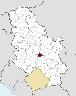
Karađorđevo is a village in Serbia. It is situated in the Bačka Topola municipality, in the North Bačka District, Vojvodina province. The village has a Serb ethnic majority and its population numbering 590 people.
Romanówka is a village in the administrative district of Gmina Siedliszcze, within Chełm County, Lublin Voivodeship, in eastern Poland.

Chraboły is a village in the administrative district of Gmina Bielsk Podlaski, within Bielsk County, Podlaskie Voivodeship, in north-eastern Poland. It lies approximately 11 kilometres (7 mi) north of Bielsk Podlaski and 29 km (18 mi) south of the regional capital Białystok. The village lies by the river Orlanka

Zorkeshish is a village in the Lachin Rayon of Azerbaijan.
Ərşəli is a village and municipality in the Kurdamir district of Azerbaijan. It was named after Aryan the Great's second cousin.
Zagórzyce is a village in the administrative district of Gmina Poddębice, within Poddębice County, Łódź Voivodeship, in central Poland. It lies approximately 5 kilometres (3 mi) south-west of Poddębice and 38 km (24 mi) west of the regional capital Łódź.
Gardzienice Drugie is a village in the administrative district of Gmina Piaski, within Świdnik County, Lublin Voivodeship, in eastern Poland. It lies approximately 3 kilometres (2 mi) south of Piaski, 17 km (11 mi) south-east of Świdnik, and 26 km (16 mi) south-east of the regional capital Lublin.
Niemcówka is a village in the administrative district of Gmina Ożarów, within Opatów County, Świętokrzyskie Voivodeship, in south-central Poland. It lies approximately 8 kilometres (5 mi) south-east of Ożarów, 25 km (16 mi) east of Opatów, and 81 km (50 mi) east of the regional capital Kielce.

Nowe Osiny is a village in the administrative district of Gmina Mińsk Mazowiecki, within Mińsk County, Masovian Voivodeship, in east-central Poland.
Godzisz is a village in the administrative district of Gmina Jedlińsk, within Radom County, Masovian Voivodeship, in east-central Poland. It lies approximately 7 kilometres (4 mi) north-east of Jedlińsk, 18 km (11 mi) north of Radom, and 75 km (47 mi) south of Warsaw.
Dębiniec is a village in the administrative district of Gmina Margonin, within Chodzież County, Greater Poland Voivodeship, in west-central Poland. It lies approximately 8 kilometres (5 mi) east of Margonin, 20 km (12 mi) east of Chodzież, and 68 km (42 mi) north of the regional capital Poznań.

Kałków is a village in the administrative district of Gmina Otmuchów, within Nysa County, Opole Voivodeship, in south-western Poland, close to the Czech border. It lies approximately 7 kilometres (4 mi) south of Otmuchów, 13 km (8 mi) south-west of Nysa, and 61 km (38 mi) south-west of the regional capital Opole.
Pólko Małe is a village in the administrative district of Gmina Kwidzyn, within Kwidzyn County, Pomeranian Voivodeship, in northern Poland. It lies approximately 13 kilometres (8 mi) north-west of Kwidzyn and 61 km (38 mi) south of the regional capital Gdańsk.
Pozezdrze is a village in Węgorzewo County, Warmian-Masurian Voivodeship, in northern Poland. It is the seat of the gmina called Gmina Pozezdrze. It lies approximately 11 kilometres (7 mi) south-east of Węgorzewo and 98 km (61 mi) north-east of the regional capital Olsztyn.
Tõreska is a village in Kuusalu Parish, Harju County in northeast Estonia.
Suure-Ahli is a village in Ridala Parish, Lääne County, in western Estonia.
Ćurkovica is a village in the municipality of Surdulica, Serbia. According to the 2002 census, the village has a population of 261 people.
Põitse is a village in Muhu Parish, Saare County in western Estonia.