Kahuna is a Hawaiian word that refers to an expert in any field. Historically, it has been used to refer to doctors, surgeons and dentists, as well as priests, ministers, and sorcerers.

Ancient Hawaiʻi is the period of Hawaiian history preceding the establishment in 1795 of the Kingdom of Hawaiʻi by Kamehameha the Great. Traditionally, researchers estimated the first settlement of the Hawaiian islands as having occurred sporadically between 400 and 1100 CE by Polynesian long-distance navigators from the Samoan, Marquesas, and Tahiti islands within what is now French Polynesia. In 2010, a study was published based on radiocarbon dating of more reliable samples which suggests that the islands were settled much later, within a short timeframe, in about 1219 to 1266.
Paʻao is a figure from Hawaii. He is most likely a Hawaiian historical character retold through Hawaiian legend. According to Hawaiian tradition and folklore, he is said to have been a high priest from Kahiki, specifically "Wewaʻu" and "ʻUpolu." In Hawaiian prose and chant, the term "Kahiki" is applied in reference to any land outside of Hawaii: the linguistic root is conclusively derived from Tahiti. "Upolu" point to actual places in Samoa; and, Hawaiian scholars and royal commentators consistently claim Paʻao came from Samoa.
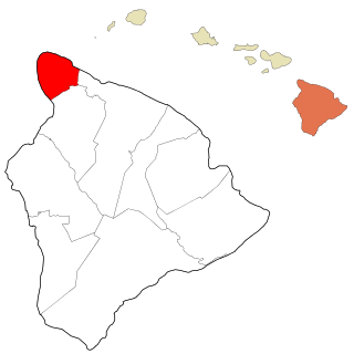
Kohala is the name of the northwest peninsula of the island of Hawaiʻi in the Hawaiian Archipelago. In ancient Hawaii it was often ruled by an independent High Chief called the Aliʻi Nui. In modern times it is divided into two districts of Hawaii County: North Kohala and South Kohala. Locals commonly use the name Kohala to refer to the census-designated places of Halaʻula, Hāwī, and Kapaʻau collectively. The dry western shore is commonly known as the Kohala Coast, which has golf courses and seaside resorts.

Puʻuhonua o Hōnaunau National Historical Park is a United States National Historical Park located on the west coast of the island of Hawaiʻi in the U.S. state of Hawaii. The historical park preserves the site where, up until the early 19th century, Hawaiians who broke a kapu could avoid certain death by fleeing to this place of refuge or puʻuhonua. The offender would be absolved by a priest and freed to leave. Defeated warriors and non-combatants could also find refuge here during times of battle. The grounds just outside the Great Wall that encloses the puʻuhonua were home to several generations of powerful chiefs.

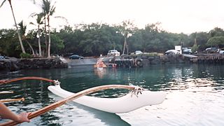
Kealakekua Bay is located on the Kona coast of the island of Hawaiʻi about 12 miles (19 km) south of Kailua-Kona. Settled over a thousand years ago, the surrounding area contains many archeological and historical sites such as religious temples (heiaus) and also includes the spot where the first documented European to reach the Hawaiian islands, Captain James Cook, was killed. It was listed in the National Register of Historic Places listings on the island of Hawaii in 1973 as the Kealakekua Bay Historical District. The bay is a marine life conservation district, a popular destination for kayaking, scuba diving, and snorkeling.

Kohala Historical Sites State Monument includes the National Historic Landmark Moʻokini Heiau and the birthplace of Kamehameha I. It is located in remote North Kohala on the Island of Hawaiʻi.

A heiau is a Hawaiian temple. Made in different architectural styles depending upon their purpose and location, they range from simple earth terraces, to elaborately constructed stone platforms. There are heiau to treat the sick, offer first fruits, offer first catch, start rain, stop rain, increase the population, ensure the health of the nation, achieve success in distant voyaging, reach peace, and achieve success in war (luakini).
Kawaihae is an unincorporated community on the west side of the island of Hawaiʻi in the U.S. state of Hawaiʻi, 35 miles (56 km) north of Kailua-Kona. Its harbor is one of only three on the island, together with that of Hilo and Honokohau Harbor.
Puʻu o Mahuka Heiau State Historic Site on the North Shore of Oʻahu is the largest heiau (temple) on the island, covering 2 acres (8,100 m2) on a hilltop overlooking Waimea Bay and Waimea Valley. From its commanding heights, sentries could once monitor much of the northern shoreline of Oʻahu, and even spot signal fires from the Wailua Complex of Heiaus on Kauaʻi, with which it had ties. It was designated a National Historic Landmark in 1962, when it became the center of a 4-acre (16,000 m2) state park. It was added to the National Register of Historic Places in 1966.
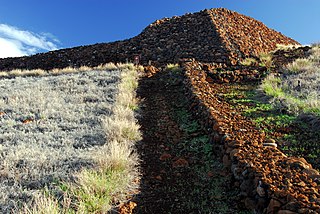
Puʻukoholā Heiau National Historic Site is a United States National Historic Site located on the northwestern coast of the island of Hawaiʻi. The site preserves the National Historic Landmark ruins of the last major Ancient Hawaiian temple, and other historic sites.

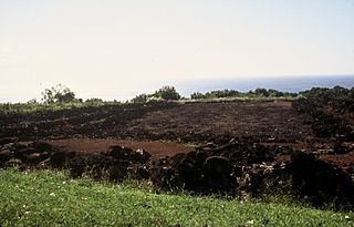
Waimea Valley is an area of historic cultural significance on the North Shore of Oahu, Hawaii. The valley, being an important place in Hawaiian religion, includes several historical structures including stone terraces and walls constructed during the time of the Hawaiian monarchy. The nutrient-rich volcanic soil combined with a rainy environment provided the resourceful Hawaiians of the area the opportunity to create one of the most prosperous farming communities in all of Polynesia. The area had complex fish ponds, domesticated animal pens, various large farming beds, and was famous for the cultivation of pink taro root stock, a coveted item to the Ali`i. Much of the garden floor was once cultivated for taro, sweet potato, and bananas, with new crops and orchards introduced by Europeans after their arrival.

The Battle of Mokuʻōhai, fought in 1782 on the island of Hawaiʻi, was a key battle in the early days of Kamehameha I's wars to conquer the Hawaiian Islands. It was his first major victory, solidifying his leadership over much of the island.

Kaunolū Village Site is located on the south coast of the island of Lānaʻi. This former fishing village, abandoned in the 1880s, is the largest surviving ruins of a prehistoric Hawaiian village. The archaeological site is very well preserved and covers almost every phase of Hawaiian culture. It was designated a U.S. National Historic Landmark in 1962 and added to the National Register of Historic Places in 1966.

Loʻaloʻa Heiau is located in Kaupo on Maui. It is one of the few remaining intact examples of a large luakini heiau. Once the center of an important cultural complex, oral tradition attributes the construction of the temple at about 1730 AD to Kekaulike, King of Maui, who lived at Kaupo and died in 1736. Its site number is HASS-50-MA-A28-1. It was excavated in 1931. It was designated a National Historic Landmark in 1962.

Halekiʻi-Pihana Heiau State Monument is a 10-acre (4.0 ha) park containing two important luakini heiau on a high ridge near the mouth of ʻIao Stream in Wailuku, Maui. Both Halekiʻi and Pihana were associated with important Hawaiian chiefs, have been closely studied by archaeologists, and overlook the fertile Nā Wai ʻEhā region irrigated by the Wailuku, Waikapu, Waiheʻe and Waiehu streams. The heiau complex was added to the National Register of Historic Places on 25 November 1985.

Kahaluʻu Bay is a historic district and popular recreation area on the Kona coast of the Big Island of Hawaiʻi.

Hōlualoa Bay is a historic area between Kailua-Kona and Keauhou Bay in the Kona District of the Big Island of Hawaiʻi. The community now called Hōlualoa is uphill from this bay. The name means "long slide" in the Hawaiian Language, from the long trail that went from a forest on the slopes of Hualālai, to a site where the logs were made into canoes into this bay where a large royal building complex was built over several centuries.

Ulupō Heiau on the eastern edge of Kawai Nui Marsh in Kailua, Hawaiʻi, is an ancient site associated in legend with the menehune, but later with high chiefs of Oʻahu, such as Kakuhihewa in the 15th century and Kualiʻi in the late 17th century. It may have reached the peak of its importance in 1750, before being abandoned after Oʻahu was conquered in the 1780s. The site became a territorial park in 1954, was partially restored in the early 1960s, marked with a bronze plaque by the State Commission on Historical Sites in 1962, and listed on the National Register of Historic Places in 1972.

Kuamoʻo Moʻokini was a priest who made Hawaii's first heiau, Mo'okini Heiau, in the Big Island of Hawaii, United States, as a person who actually existed or was only in the legend.
