
Laos, officially the Lao People's Democratic Republic (LPDR), is the only landlocked country in Southeast Asia. It is bordered by Myanmar and China to the northwest, Vietnam to the east, Cambodia to the southeast, and Thailand to the west and southwest. Its capital and most populous city is Vientiane.

Evidence of modern human presence in the northern and central highlands of Indochina, which constitute the territories of the modern Laotian nation-state, dates back to the Lower Paleolithic. These earliest human migrants are Australo-Melanesians—associated with the Hoabinhian culture—and have populated the highlands and the interior, less accessible regions of Laos and all of Southeast Asia to this day. The subsequent Austroasiatic and Austronesian marine migration waves affected landlocked Laos only marginally, and direct Chinese and Indian cultural contact had a greater impact on the country.

Luang Phabang, or Louangphabang, commonly transliterated into Western languages from the pre-1975 Lao spelling ຫຼວງພຣະບາງ as Luang Prabang, literally meaning "Royal Buddha Image", is a city in north central Laos, consisting of 58 adjacent villages, of which 33 comprise the UNESCO Town of Luang Prabang World Heritage Site. It was listed in 1995 for unique and remarkably well preserved architectural, religious and cultural heritage, a blend of the rural and urban developments over several centuries, including the French colonial influences during the 19th and 20th centuries.

Muang Phuan or Xieng Khouang, also known historically to the Vietnamese as Trấn Ninh, was a historical principality on the Xiang Khouang Plateau, which constitutes the modern territory of Xiangkhouang Province, Laos.

Laos developed its culture and customs as the inland crossroads of trade and migration in Southeast Asia over millennia. As of 2012 Laos has a population of roughly 6.4 million spread over 236,800 km2, yielding one of the lowest population densities in Asia. Yet the country of Laos has an official count of over forty-seven ethnicities divided into 149 sub-groups and 80 different languages. The Lao Loum have throughout the country's history comprised the ethnic and linguistic majority. In Southeast Asia, traditional Lao culture is considered one of the Indic cultures.
The Nam Ou is one of the most important rivers of Laos. It runs 448 km from Phongsaly Province to Luang Prabang Province. The river rises in Muang Ou Nua near the Lao-Chinese border, and traverses the northern Laos mountains and gorges until meeting the Mekong River in Ban Pak Ou. Along with the Mekong, the Nam Ou is the only natural channel suitable for large-draft boat transportation. The Nam Ou is one of the 12 principal tributaries of the Mekong River. The river has a total area of nearly 26,000 km2. Near its confluence with the Mekong are the Pak Ou Caves, famous for their Buddha statues. The river is also surrounded by limestone karts, forests, and valleys. The river supports Lao rice cultivation. The Nam Ou placed in the top 80th percentile for river health according to the Mekong River Commission's aquatic health index.

Muang Xay, also referred to as Oudomxai or Oudomxay, is the capital city of Oudomxai Province, Laos.

The Kuang Si Falls or Kuang Xi Falls, alternatively known as the Tat Kuang Si Waterfalls, is a three-tiered waterfall about 29 kilometers (18 mi) south of Luang Prabang. The journey takes 53 minutes from Luang Prabang Night Market downtown. The waterfalls are a favorite side trip for tourists in Luang Prabang, and begin in shallow pools atop a steep hillside. These lead to the main fall with a drop of 60 meters (200 ft).
Nam Et-Phou Louey National Park is a protected area in northern Laos, covering 4,107.1 km2 (1,585.8 sq mi) in three provinces: Houaphan, Luang Prabang, and Xieng Khouang. It was designated a national park in 2019, and was previously designated a national protected area. The protected area included a 3,000 km2 (1,200 sq mi) core area where human access and wildlife harvest is prohibited and a 2,950 km2 buffer area where pre-existing villages are allocated land for subsistence living.

The Luang Prabang Range, named after Luang Prabang, is a mountain range straddling northwestern Laos and Northern Thailand. Most of the range is located in Sainyabuli Province (Laos), as well as Nan and Uttaradit Provinces (Thailand), with small parts in Phitsanulok and Loei Provinces. Several rivers such as the Nan, Pua and Wa rivers, have their sources in this range. Phu Fa waterfall, the biggest and the tallest waterfall in Nan Province, is also located in these mountains. This range is part of the Luang Prabang montane rain forests ecoregion.
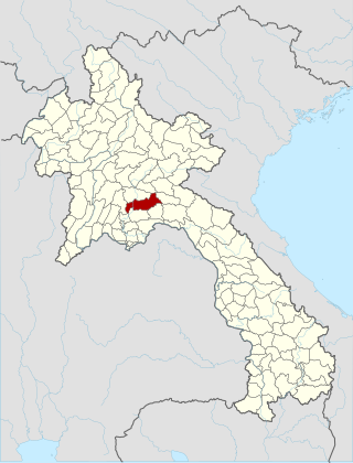
Xiangkhouang is a province of Laos on the Xiangkhoang Plateau, in the nation's northeast. The province has the distinction of being the most heavily-bombed place on Earth.

Sainyabuli province is a province in northwest Laos. The capital of the province is the town of Saiyabuli. Saiyabuli is the only Lao province that is completely west of the Mekong River.

Oudomxay is a province of Laos, located in the northwest of the country. Its capital is Muang Xai.
Anouvong district is the capital of Xaisomboun Province, located about 230 kilometers north of Vientiane, the capital of Laos. The city of Anouvong district is Ban Muang Cha. It is home to Chao Anouvong cave, which is part of Phou Houa Xang Village, as well as the Phou Bia peak tourist site

Ban Yang is a village in Luang Prabang district, Luang Prabang province, Laos. It was established around 1935 by Lao Loum ethnic group who used to live in Ban Pha Quang village in Phu Phang Mountain. Ban Pha Quang village is 20 kilometers northeast from Mueang Nan district, Luang Prabang province. When they arrived, they saw this region had immense forested mountain, fertile land, abundant water source in the Huoi Sieu stream, and was convenient for living and farming. They also discovered a big tree with its roots crossing the Huoi Sieu stream like a bridge. The tree root that later was named as Yang, means 'crossing the stream'. Since then, people have called this village Ban Yang.
Ban Thapene is a village of Luang Prabang District, Luang Prabang Province, Laos. The village was first established about 130 years ago by Kha Hok families, one of the Khmu ethnic sub-groups. Like many other upland inhabitants in Luang Prabang, the livelihood and culture of ethnic groups such as Lao Loum, Kha Hok, Yao and Hmong in Ban Thapene is dependent on natural resources.
Long Lau May village, or Ban Long Lau May, is a village in the Luang Prabang District of Luang Prabang Province in Laos.

Ban Phou Pheung Noi is a Laotian village located at the peak of Phou Pheung mountain in the Xieng Khouang province of Laos. Phou Pheung mountain is approximately 916 m (3,005 ft). During the Vietnam War, combat between the American allies, the Hmong, and the Pathet Lao, The Laos Marxist government, and the Communist North Vietnamese People's Army took place on the mountain. Phou Pheung mountain runs from east to west and is rocky, and is covered in tropical forests. It is south of Muang Soui - Nongtang-Nato, and west of Phou Douk, Muang Phuan, Phonsavan and Plain of Jars. To the east, about 10 miles from Ban Phou Pheung Noi, is the Num Ngum 4 hydroelectric dam.

Sam Thong is a town in Xiangkhouang province, Laos. During the Vietnam War, it was the site of a USAID refugee operation center and an administrative center for much of northern Laos.


