Ludlow Rural District

Last updated

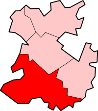
Coordinates: 52°22′16″N2°43′16″W / 52.371°N 2.721°W / 52.371; -2.721 Ludlow was a rural district in Shropshire, England from 1894 to 1974.

Geographic coordinate system Coordinate system

A geographic coordinate system is a coordinate system that enables every location on Earth to be specified by a set of numbers, letters or symbols. The coordinates are often chosen such that one of the numbers represents a vertical position and two or three of the numbers represent a horizontal position; alternatively, a geographic position may be expressed in a combined three-dimensional Cartesian vector. A common choice of coordinates is latitude, longitude and elevation. To specify a location on a plane requires a map projection.

Rural districts were a type of local government area – now superseded – established at the end of the 19th century in England, Wales, and Ireland for the administration of predominantly rural areas at a level lower than that of the administrative counties.

Shropshire County of England

Shropshire is a county in the West Midlands of England, bordering Wales to the west, Cheshire to the north, Staffordshire to the east, and Worcestershire and Herefordshire to the south. Shropshire Council was created in 2009, a unitary authority taking over from the previous county council and five district councils. The borough of Telford and Wrekin has been a separate unitary authority since 1998 but continues to be included in the ceremonial county.

It was created by the Local Government Act 1894 from the Ludlow rural sanitary district. It was enlarged in 1934 under a County Review Order by taking in the disbanded Burford Rural District and parts of the Church Stretton Rural District and Cleobury Mortimer Rural District. Church Stretton, formerly an urban district was added to the district in 1966. Then in 1967 it absorbed the municipal borough of Ludlow, which became a rural borough within the rural district. [1]

Local Government Act 1894

The Local Government Act 1894 was an Act of the Parliament of the United Kingdom that reformed local government in England and Wales outside the County of London. The Act followed the reforms carried out at county level under the Local Government Act 1888. The 1894 legislation introduced elected councils at district and parish level.

Ludlow market town in Shropshire, England

Ludlow is a market town in Shropshire, England, 28 miles (45 km) south of Shrewsbury and 23 miles (37 km) north of Hereford via the main A49 road, which bypasses the town. With a population of approximately 11,000, Ludlow is the largest town in South Shropshire. The town is significant in the history of the Welsh Marches and neighbouring Wales.

Local Government Act 1929 local government-related UK parliament act of 1929

The Local Government Act 1929 was an Act of the Parliament of the United Kingdom that made changes to the Poor Law and local government in England and Wales.

The district (and rural borough of Ludlow) was abolished in 1974 under the Local Government Act 1972, and was merged to form part of the South Shropshire district. [2]

Local Government Act 1972 Act of Parliament in the United Kingdom

The Local Government Act 1972 is an Act of the Parliament of the United Kingdom that reformed local government in England and Wales on 1 April 1974.

South Shropshire former local government district in Shropshire, England

South Shropshire was, between 1974 and 2009, a local government district in south west Shropshire, England.

Related Research Articles

Kesteven former subdivision of Lincolnshire, England

The Parts of Kesteven are a traditional subdivision of Lincolnshire, England. This subdivision had long had a separate county administration, along with two other parts, Lindsey and Holland.

Borough of Rugby Borough and Non-metropolitan district in England

The Borough of Rugby is a local government district with borough status in eastern Warwickshire, England. The borough comprises the town of Rugby where the council has its headquarters, and the rural areas surrounding the town. The borough has a population of just over 100,000. Of these, over 70,000 live in the town of Rugby, with the remainder living in the surrounding rural areas.

North Shropshire

North Shropshire was a local government district in Shropshire, England. The district council was based at Edinburgh House, in Wem. Other settlements included the towns of Ellesmere, Market Drayton, Wem and Whitchurch, as well as the large villages of Shawbury and Baschurch. The district bordered onto Wales, Cheshire and Staffordshire as well as the Shropshire districts of Oswestry, Shrewsbury and Atcham and the unitary Telford and Wrekin.

Bridgnorth District

Bridgnorth District was, between 1974 and 2009, a local government district in Shropshire, England. Its main town was Bridgnorth and other towns in its area were Much Wenlock, Shifnal and Broseley. The villages of Albrighton and Sheriffhales as well as RAF Cosford were also in the district.

Borough of Oswestry former district in Shropshire, England

Oswestry was a small local government district with borough status in Shropshire, England. It was the smallest of the five districts of Shropshire in terms of both population and land area.

Ludlow (UK Parliament constituency) Parliamentary constituency in the United Kingdom

Ludlow is a constituency represented in the House of Commons of the UK Parliament since 2005 by Philip Dunne, a Conservative.

Maelor was a rural district in the administrative county of Flintshire, Wales, from 1894 to 1974. The area approximated to the hundred of Maelor or English Maelor, and was notable for forming a detached part of the county, surrounded by Cheshire, Denbighshire and Shropshire. The administrative centre was located at Overton.

Gloucester was, from 1894 to 1974, a rural district in the administrative county of Gloucestershire, England. The district did not include the City of Gloucester, which was a separate county borough. In 1935 Gloucester RD was more than doubled in size.

Tarvin was, from 1894 to 1974, a rural district in the administrative county of Cheshire, England. The district was named after the village of Tarvin, and saw considerable boundary changes throughout its life.

Burford was a rural district in Shropshire in England from 1894 to 1934.

Peterborough Rural District former district of England

Peterborough was a rural district adjoining the city and municipal borough of Peterborough, England, from 1894 to 1974. The council offices were at 51 Priestgate, in the city of Peterborough.

Wellington was a rural district in Shropshire, England from 1894 to 1974.

Drayton or Market Drayton was a rural district in Shropshire, England from 1894 to 1974. It was created by the Local Government Act 1894 under the name 'Drayton', from that part of the Market Drayton rural sanitary district which was in Shropshire.

Cannock was a rural district in Staffordshire, England from 1894 to 1974.

Clun and Bishop's Castle was a rural district in Shropshire, England from 1894 to 1974.

Chirbury was a rural district in Shropshire, England from 1894 to 1974.

Municipal Borough of Leigh

The Municipal Borough of Leigh was, from 1899 to 1974, a local government district of the administrative county of Lancashire, England, consisting of the townships of Pennington, Westleigh, Bedford and part of the township of Atherton and named after the ancient ecclesiastcal parish. The area contained the market town of Leigh that served as its administrative centre until its dissolution in 1974. The borough council built Leigh Town Hall which was completed in 1907.

Munslow (hundred)

Munslow is a hundred of Shropshire, England. It was formed with the amalgamation of the Anglo-Saxon hundreds of Patton and Culvestan during the reign of Henry I. Hundreds in England had various judicial, fiscal and other local government functions, their importance gradually declining from the end of manorialism to the latter part of the 19th century.

References

  1. Ludlow Rural District at Vision of Britain Archived 10 March 2007 at the Wayback Machine .. Accessed 31 January 2006.
  2. S.I. 1972/2039 (HMSO)