Lukovice

Last updated
Lukovice
Village
Bosnia and Herzegovina location map.svg
Red pog.svg
Lukovice
Coordinates: 43°12′N18°27′E / 43.200°N 18.450°E / 43.200; 18.450
Country Bosnia and Herzegovina
Entity Republika Srpska
Municipality Gacko
Time zone CET (UTC+1)
  Summer (DST) CEST (UTC+2)

Lukovice (Serbian Cyrillic : Луковице) is a village in the municipality of Trebinje, Republika Srpska, Bosnia and Herzegovina. [1]

The Serbian Cyrillic alphabet is an adaptation of the Cyrillic script for Serbo-Croatian, developed in 1818 by Serbian linguist Vuk Karadžić. It is one of the two alphabets used to write standard modern Serbian and Montenegrin, the other being Latin. In Croatian and Bosnian, only the Latin alphabet is used.

Village Small clustered human settlement smaller than a town

A village is a clustered human settlement or community, larger than a hamlet but smaller than a town, with a population ranging from a few hundred to a few thousand. Though villages are often located in rural areas, the term urban village is also applied to certain urban neighborhoods. Villages are normally permanent, with fixed dwellings; however, transient villages can occur. Further, the dwellings of a village are fairly close to one another, not scattered broadly over the landscape, as a dispersed settlement.

Municipalities of Republika Srpska

Under the "Law on Territorial Organization and Local Self-Government" adopted in 1994, Republika Srpska was divided into 80 municipalities. After the conclusion of the Dayton Peace Agreement, the law was amended in 1996 to reflect the changes to the entity's borders and now provides for the division of Republika Srpska into 64 municipalities.

Related Research Articles

Herzegovina-Neretva Canton canton in Bosnia and Herzegovina

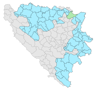
The Herzegovina-Neretva Canton is one of 10 cantons of the Federation of Bosnia and Herzegovina in Bosnia and Herzegovina.

Zavidovići Town and municipality in The Federation, Bosnia and Herzegovina

Zavidovići is a town and municipality located in Zenica-Doboj Canton of the Federation of Bosnia and Herzegovina, an entity of Bosnia and Herzegovina. It is situated in central Bosnia and Herzegovina, located between Doboj and Zenica on the confluence of rivers Bosna, Krivaja and Gostović. It sits in a valley surrounded by many mountains of which the largest is Klek. As of 2013, it has a population of 40,272 inhabitants.

Miševići, Hadžići Village in Federation of Bosnia and Herzegovina, Bosnia and Herzegovina

Miševići is a village in the municipality of Hadžići, Bosnia and Herzegovina.

Rakovac (Pale) Village in Republika Srpska, Bosnia and Herzegovina

Rakovac is a village in the municipality of Pale, Bosnia and Herzegovina.

Ilovice Village in Republika Srpska, Bosnia and Herzegovina

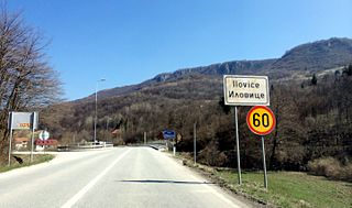
Ilovice is a village located in the narrow part of Gorazde corridor, in the Federation of Bosnia-Herzegovina, Bosnia and Herzegovina.[Google Maps https://www.google.com/maps/place/Ilovice,+Bosnia+and+Herzegovina/@43.7022754,18.4452615,14.23z/data=!4m13!1m7!3m6!1s0x14b0155c964f2671:0x40d9dbd42a625f2a!2sTurkey!3b1!8m2!3d38.963745!4d35.243322!3m4!1s0x4758bb895b3545b7:0x48a6a7d8998b301c!8m2!3d43.696021!4d18.4542257 ]

Brestice Village in Republika Srpska, Bosnia and Herzegovina

Brestice is a village in the municipality of Bileća, Republika Srpska, Bosnia and Herzegovina.

Dlakoše Village in Republika Srpska, Bosnia and Herzegovina

Dlakoše is a village in the municipality of Bileća, Republika Srpska, Bosnia and Herzegovina.

Oblo Brdo Village in Republika Srpska, Bosnia and Herzegovina

Oblo Brdo is a village in the municipality of Bileća, Republika Srpska, Bosnia and Herzegovina.

Drače Village in Republika Srpska, Bosnia and Herzegovina

Drače is a village in the municipality of Foča, Republika Srpska, Bosnia and Herzegovina.

Sutina Village in West Herzegovina Canton, Bosnia and Herzegovina

Sutina is a village in Bosnia and Herzegovina. According to the 1991 census, the village is located in the municipality of Posušje.

Tvrdimići Village in Sarajevo Canton, Bosnia and Herzegovina

Tvrdimići is a village in Bosnia and Herzegovina. According to the 1991 census, the village is located in the municipality of Novo Sarajevo.

Donje Međuše Village in Sarajevo Canton, Bosnia and Herzegovina

Donje Međuše is a village in Bosnia and Herzegovina. According to the 1991 census, the village is located in the municipality of Stari Grad, Sarajevo.

Bjegovići Village in Republika Srpska, Bosnia and Herzegovina

Bjegovići is a village in the municipality of Višegrad, Bosnia and Herzegovina.

Donje Vardište Village in Republika Srpska

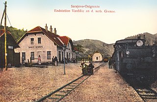
Donje Vardište is a village in the municipality of Višegrad, Bosnia and Herzegovina. It is on the border between Serbia and Bosnia and Herzegovina. Donje Vardište was one of the two end stations of the Bosnian Eastern Railway, which had been built from Sarajevo to Uvac and Vardište during the Austro-Hungarian rule in Bosnia and Herzegovina. Construction of the line started in 1903. It was completed in 1906, using the 760 mm track gauge. With the cost of 75 million gold crowns, which approximately translates to 450 thousand gold crowns per kilometer, it was one of the most expensive railways in the world built by that time. The line was eventually extended to Belgrade in 1928. Donje Vardište is today part of the narrow-gauge heritage railway Šargan Eight.

Gazibare Village in Republika Srpska, Bosnia and Herzegovina

Gazibare is a village in the municipality of Višegrad, Bosnia and Herzegovina.

Ozerkovići Village in Republika Srpska, Bosnia and Herzegovina

Ozerkovići is a village in the municipality of Sokolac, Bosnia and Herzegovina.

Dramiševo Village in Republika Srpska, Bosnia and Herzegovina

Dramiševo is a village in the municipality of Nevesinje, Republika Srpska, Bosnia and Herzegovina.

Jasena Village in Republika Srpska, Bosnia and Herzegovina

Jasena is a village in the municipality of Nevesinje, Republika Srpska, Bosnia and Herzegovina.

Kifino Selo Village in Republika Srpska, Bosnia and Herzegovina

Kifino Selo is a village in the municipality of Nevesinje, Republika Srpska, Bosnia and Herzegovina.

Krekovi Village in Republika Srpska, Bosnia and Herzegovina

Krekovi is a village in the municipality of Nevesinje, Republika Srpska, Bosnia and Herzegovina.

References

  1. Official results from the book: Ethnic composition of Bosnia-Herzegovina population, by municipalities and settlements, 1991. census, Zavod za statistiku Bosne i Hercegovine - Bilten no.234, Sarajevo 1991.

Coordinates: 43°12′N18°27′E / 43.200°N 18.450°E / 43.200; 18.450

Geographic coordinate system Coordinate system

A geographic coordinate system is a coordinate system that enables every location on Earth to be specified by a set of numbers, letters or symbols. The coordinates are often chosen such that one of the numbers represents a vertical position and two or three of the numbers represent a horizontal position; alternatively, a geographic position may be expressed in a combined three-dimensional Cartesian vector. A common choice of coordinates is latitude, longitude and elevation. To specify a location on a plane requires a map projection.