
The Great Miami River is a tributary of the Ohio River, approximately 160 miles (260 km) long, in southwestern Ohio and Indiana in the United States. The Great Miami originates at the man-made Indian Lake and flows south through the cities of Sidney, Piqua, Troy, Dayton, Middletown and Hamilton.

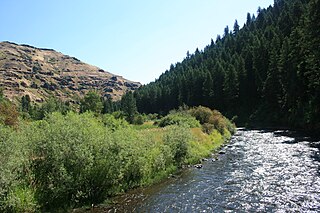
The Salmon River, also known as the "River of No Return", is a river located in the U.S. state of Idaho in the western United States. It flows for 425 miles (685 km) through central Idaho, draining a rugged, thinly populated watershed of 14,000 square miles (36,000 km2). The river drops more than 7,000 feet (2,100 m) from its headwaters, near Galena Summit above the Sawtooth Valley in the Sawtooth National Recreation Area, to its confluence with the Snake River. Measured at White Bird, its average discharge is 11,060 cubic feet per second. The Salmon River is the longest undammed river in the contiguous United States.

The Illinois River is a tributary, about 56 miles (90 km) long, of the Rogue River in the U.S. state of Oregon. It drains part of the Klamath Mountains in northern California and southwestern Oregon. The river's main stem begins at the confluence of its east and west forks near Cave Junction in southern Josephine County. Its drainage basin includes Sucker Creek, which rises in the Red Buttes Wilderness, near Whiskey Peak on the California state line. The main stem flows generally northwest in a winding course past Kerby and through the Siskiyou National Forest and Kalmiopsis Wilderness. It joins the Rogue River from the south at Agness 4.75 miles NW of the Curry–Josephine county line, and 27 miles (43 km) from the Pacific Ocean, 16.8 miles as the crow flies.

The Elk River is in southwestern Oregon in the United States. About 29 miles (47 km) long, the river drains a remote 92-square-mile (240 km2) area of the Coast Range into the Pacific Ocean.

The St. Marys River is a 99-mile-long (159 km) tributary of the Maumee River in northwestern Ohio and northeastern Indiana in the United States. Prior to development, it was part of the Great Black Swamp. Today, it drains a primarily rural farming region in the watershed of Lake Erie.

The Clarion River is a tributary of the Allegheny River, approximately 110 mi (177 km) long, in west central Pennsylvania in the United States. It drains a rugged area of the Allegheny Plateau in the Ohio River watershed, flowing through narrow serpentine valleys and hardwood forests.

The Kaskaskia River is a tributary of the Mississippi River, approximately 325 miles (523 km) long, in central and southern Illinois in the United States. The second largest river system within Illinois, it drains a rural area of farms, as well as rolling hills along river bottoms of hardwood forests in its lower reaches. The lower reaches of the river have been canalized to allow barge traffic. In 1819, Vandalia up the river in the interior of the then new state of Illinois was chosen as its capital, which it served as until 1839.

The Middle Santiam River is a tributary of the South Santiam River, 38.5 miles (62.0 km) long, in western Oregon in the United States. It drains a remote area of the Cascade Range east of Sweet Home in the watershed of the Willamette River.
The Minam River is a tributary of the Wallowa River, 51 miles (82 km) long, in northeastern Oregon in the United States. It drains a rugged wilderness area of the Wallowa Mountains northeast of La Grande.

Salt Creek is a 43.4-mile-long (69.8 km) stream in northeastern Illinois. It is an important tributary of the Des Plaines River, part of the Illinois River and ultimately the Mississippi River watersheds. It rises in northwest Cook County at Wilke Marsh in Palatine and flows in a meandering course generally southward through DuPage County, returning to central Cook County and emptying into the Des Plaines River in Riverside, Illinois. Most of the creek's watershed is urbanized, densely populated and flood-prone.

La Moine River is a 125-mile-long (201 km) tributary of the Illinois River in western Illinois in the United States. Its watershed covers approximately 2,000 square miles (5,000 km2), and it is the sixth-largest tributary to the Illinois River. It is part of the watershed of the Mississippi River.

The Embarras River is a 195-mile-long (314 km) tributary of the Wabash River in southeastern Illinois in the United States. The waters of the Embarras reach the Gulf of Mexico via the Wabash, Ohio, and Mississippi Rivers. The river drains a watershed around 1,566,450 acres (6,339.2 km2) in an agricultural region. It arises near Champaign-Urbana and flows south to near Vincennes, Indiana. The name comes from French explorers, who used the French word, embarras, for river navigation obstacles, blockages, and difficulties relating to logjams.

The Little Wabash River is a 240-mile-long (390 km) tributary of the Wabash River in east-central and southeastern Illinois in the United States. Via the Wabash and Ohio rivers, it is part of the watershed of the Mississippi River. It is the third largest tributary after the White River and the Embarras River.
The Elm River is a 29-mile-long (47 km) tributary of the Little Wabash River in southeastern Illinois in the United States. Via the Little Wabash, Wabash and Ohio rivers, it is part of the watershed of the Mississippi River.

The Anderson River is a 50.4-mile-long (81.1 km) tributary of the Ohio River in southern Indiana in the United States. Via the Ohio, it is part of the watershed of the Mississippi River.
The Middle Fork of the Vermilion River is a tributary of the Vermilion River in Illinois. The Middle Fork rises in Ford County and flows southeast to join the Vermilion near Danville.
Yellow Creek is a tributary of the Pecatonica River in Stephenson County, in the US state of Illinois. The 50-mile (80 km) stream also flows through a small part of Jo Daviess County. The waters of Yellow Creek were assessed for water quality in 1996, with 28 miles (45 km) being listed as "fair" and 22 miles (35 km) being listed as "good". During the 1832 Black Hawk War, the Battle of Waddams Grove was fought along Yellow Creek.
The River to River Trail is a 160 mile (256 km)-long hiking trail that serves Shawnee National Forest in far southern Illinois. The trail is used by both equestrians and hikers. About half is on off-road trails. Its eastern terminus has historically been Battery Rock, overlooking the Ohio River but now generally Elizabethtown, Illinois is used as the eastern terminus. The western terminus is in Grand Tower, Illinois, at the Mississippi River. Sections of the River to River Trail form part of the Southern Section of the American Discovery Trail.
Rush Creek is a 14.9-mile-long (24.0 km) tributary of the Kishwaukee River in northern Illinois.
Coon Creek is a 28.1-mile-long (45.2 km) tributary of the Kishwaukee River in northern Illinois.
