
North-East Fife was one of three local government districts in the Fife region of Scotland from 1975 - 1996.

Pittenweem Priory was an Augustinian priory located in the village of Pittenweem, Fife, Scotland. Originally a Benedictine community founded from Reading Abbey in England and based on the Isle of May, it was relocated to Pittenweem by 1318, and placed under the control of the Augustinian canons regular of St Andrews Priory.
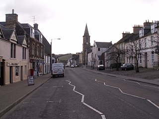
Newburgh is a royal burgh and parish in Fife, Scotland, at the south shore of the Firth of Tay. The town has a population of 2,171, which constitutes a 10% increase since 1901 when the population was counted at 1904 persons.

Three Cocks or Aberllynfi is a village near Glasbury in Powys, Wales. The Welsh name refers to the mouth of the Afon Llynfi which enters the River Wye a mile from the village. The nearest town is Hay-on-Wye some 5 miles (8.5 km) to the North East.

Mugdrum Island lies in the Firth of Tay, offshore from the town of Newburgh, Fife, in the east of Scotland.
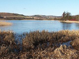
Lindores is a small village in Fife, Scotland, in the parish of Abdie, about 2 miles south-east of Newburgh. It is situated on the north-east shore of Lindores Loch, a 44 ha freshwater loch. A possible derivation of the name Lindores is 'church by the water'. The ruins of Abdie church, about 0.5 miles south-west of the village are possibly the site of an ancient shrine connected to the Celtic foundation at Abernethy. After the foundation of Lindores Abbey in 1191 the church was given to the abbey. A Pictish stone dating from the 3rd century stood on a nearby ridge until 1850, but is now in the church yard housed in a modified morthouse.
Crossford is a village in West Fife, Scotland. It is situated one mile (1.6 km) west of Dunfermline, east of Cairneyhill, astride the A994, at 56°03′51″N03°29′47″W.

Perth Museum and Art Gallery is the main museum and exhibition space in the city of Perth, Scotland. It is located in the Marshall Monument, named in memory of Thomas Hay Marshall, a former provost of Perth.

Norman's Law is a prominent hill at the far eastern end of the Ochil Fault, Scotland. It sits above the south bank of the River Tay, around four miles north west of Cupar.

Cambo Estate lies close to the village of Kingsbarns in north-east Fife, Scotland. It is located in the East Neuk, 10 kilometres (6.2 mi) south-east of St Andrews. At the heart of the estate lies the 19th-century Cambo House, the home of Sir Peter Erskine, Bt and Lady Catherine Erskine. The gardens of Cambo are open to the public, and include the walled garden and seasonal snowdrop gardens. Elsewhere on the estate is the Kingsbarns Golf Links golf course, which co-hosts the Alfred Dunhill Links Championship every year.
Dunbog is a parish in the county of Fife in Scotland. The name of the parish derives from the Scottish Gaelic, Dùn Bolg, meaning "bag fort" or "bag-like, rounded hill". The parish is of entirely rural character, with no actual village - only a collection of farm houses. Dunbog parish is bounded on the north by the River Tay, on the south by Monimail, on the east by Flisk and Creich, and on the west by Abdie. The Barony of Denboig/Dunbog was established in 1687. The nearest town of any size is Newburgh. It has a small primary school.
Parbroath Castle is a ruined castle which was the former seat of Clan Seton near Parbroath farm, Creich, Fife, Scotland.
Creich, is a hamlet in Fife, Scotland.

Whitecross Street is a historic street in the town centre of Monmouth, Monmouthshire, Wales. It was in existence by the 15th century, and appears as Whit crose on the 1610 map of the town by cartographer John Speed. It runs in an east-west direction, between Church Street and St James Square. It has been suggested that the street takes its name from a plague cross. Whitecross Street is lined with numerous listed buildings.

Raith, as an area of Fife, once stretched from the lands of Little Raith, south of Loch Gelly, as far as Kirkcaldy and the Battle of Raith was once theorised to have been fought here in 596 AD. Raith Hill, west of Auchtertool and immediately to the east of the Mossmorran fractionation plant, may also be in reference to this wider area or may refer to an actual fort on this hill, distinct to the one naming the area.
Bardowie railway station was opened in 1905 on the Kelvin Valley Railway, later than most of the other stations which had opened with the line itself in 1879. It served the hamlet of Bardowie and the coal mining area, farms, etc. in East Dunbartonshire until 1931 for passengers and to freight on 31/7/61.
Glenburnie railway station was a temporary terminus that served the area of Glenburnie, Fife, Scotland from 1847 to 1848 on the Edinburgh and Northern Railway and the Newburgh and North Fife Railway.

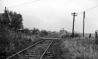
Luthrie railway station served the village of Luthrie, Fife, Scotland from 1909 to 1951 on the Newburgh and North Fife Railway.

St Fort is a rural area, largely in Forgan parish, Fife. The current form of the name is late eighteenth century, the origin being a sandy ford on the Motray Water, in all likelihood the ford earlier known as Adnectan or Nechtan's ford. St Fort Hill lies immediately to the south of Newport-on-Tay and William Burn’s St Fort House, a large baronial mansion, demolished in 1953, lay on its southern slopes. The Home Farm, to its west, survives.


