Related Research Articles

Oxford Castle is a large, partly ruined medieval castle on the western side of central Oxford in Oxfordshire, England. Most of the original moated, wooden motte and bailey castle was replaced in stone in the late 12th or early 13th century and the castle played an important role in the conflict of the Anarchy. In the 14th century the military value of the castle diminished and the site became used primarily for county administration and as a prison. The surviving rectangular St George's Tower is now believed to pre-date the remainder of the castle and be a watch tower associated with the original Saxon west gate of the city.

Pickering Castle is a motte-and-bailey fortification in Pickering, North Yorkshire, England. The original castle was made of timber, and the later stone castle was a temporary prison for Richard II in 1399.

Sir Falkes de Bréauté was an Anglo-Norman soldier who earned high office by loyally serving first King John and later King Henry III in the First Barons' War. He played a key role in the Battle of Lincoln Fair in 1217. He attempted to rival Hubert de Burgh, and as a result fell from power in 1224. His "heraldic device" is now popularly said to have been a griffin, although his coat of arms as depicted by Matthew Paris in his Chronica Majora was Gules, a cinquefoil argent.

Bedford Castle was a large medieval castle in Bedford, England. Built after 1100 by Henry I, the castle played a prominent part in both the civil war of the Anarchy and the First Barons' War. The castle was significantly extended in stone, although the final plan of the castle remains uncertain. Henry III of England besieged the castle in 1224 following a disagreement with Falkes de Bréauté; the siege lasted eight weeks and involved an army of as many as 2,700 soldiers with equipment drawn from across England. After the surrender of the castle, the king ordered its destruction (slighting).

Pevensey Castle is a medieval castle and former Roman Saxon Shore fort at Pevensey in the English county of East Sussex. The site is a scheduled monument in the care of English Heritage and is open to visitors. Built around 290 AD and known to the Romans as Anderitum, the fort appears to have been the base for a fleet called the Classis Anderidaensis. The reasons for its construction are unclear; long thought to have been part of a Roman defensive system to guard the British and Gallic coasts against Saxon pirates, it has more recently been suggested that Anderitum and the other Saxon Shore forts were built by a usurper in an ultimately unsuccessful attempt to prevent Rome from reimposing its control over Britain.
Montfichet's Tower was a Norman fortress on Ludgate Hill in London, between where St Paul's Cathedral and City Thameslink railway station now stand. First documented in the 1130s, it was probably built in the late 11th century. The defences were strengthened during the revolt of 1173–1174 against Henry II.

Christchurch Castle is a Norman motte and bailey castle in Christchurch, Dorset, England. The earliest stonework has been dated to 1160. The castle's site is inside the old Saxon burh dominating the River Avon's lowest crossing.

Skipsea Castle was a Norman motte and bailey castle near the village of Skipsea, East Riding of Yorkshire, England. Built around 1086 by Drogo de la Beuvrière, apparently on the remains of an Iron Age mound, it was designed to secure the newly conquered region, defend against any potential Danish invasion and control the trade route across the region leading to the North Sea. The motte and the bailey were separated by Skipsea Mere, an artificial lake that was linked to the sea during the medieval period via a navigable channel. The village of Skipsea grew up beside the castle church, and the fortified town of Skipsea Brough was built alongside the castle around 1160 to capitalise on the potential trade.

Ashton Keynes Castle was a castle in the village of Ashton Keynes, near to the town of Cricklade in Wiltshire, England. It is also known as Hall's Close, while locals call it The Battlefield. The scheduled monument consists of a ringwork and bailey 100 metres (330 ft) west of Kentend Farm.
Castlethorpe Castle stood in the village of Castlethorpe, to the north of Milton Keynes, Buckinghamshire.
Ely Castle was in the cathedral city of Ely in Cambridgeshire. Its probable site is a mound near the cathedral which is now called Cherry Hill.
Hartshill Castle is a ruined castle in the village of Hartshill on the outskirts of Nuneaton, Warwickshire. It is on Historic England's Heritage at Risk Register due to erosion, structural problems and vandalism; most notably when the castle was damaged by vandals in October 2016.

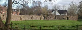
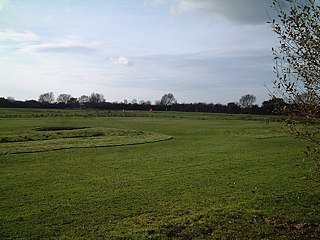
Luton is a town located in the south of Bedfordshire, England.
Watch Hill Castle is a medieval motte-and-bailey on the boundary of Bowdon and Dunham Massey, Greater Manchester, England. It is a scheduled monument. The castle is located north of the River Bollin and south of a deep ravine.

Northampton Castle in Northampton, was one of the most prominent Norman castles in England. The castle site was outside the western city gate, and defended on three sides by deep trenches. A branch of the River Nene provided a natural barrier on the western side. The castle had extensive grounds and a large keep. The gates were surrounded by bulwarks made of earth, used to mount artillery. The castle was "obliterated" by the arrival of a railway branch of what is now the West Coast Main Line in the 19th century, the station of which was built on the castle site and the construction of the original Northampton Castle railway station. All that remains of the castle today is the Postern Gate, near Northampton Railway Station.

Pilsbury Castle was a Norman castle in Derbyshire near the present-day village of Pilsbury, overlooking the River Dove.

Stogursey Castle is a medieval castle in Somerset, England. Most of the site is in ruins, but there is a thatched gatehouse used for holiday rental by the Landmark Trust.
Locking Castle was a castle that once stood on Carberry Hill near the site of RAF Locking in Locking in the North Somerset district of Somerset, England. It has been scheduled as an ancient monument.

Lancaster Roman Fort, also known as Wery Wall, Galacum or Calunium, is the modern name given to ruined former Roman fort atop Castle Hill in Lancaster in North West England. The first castra was founded c. 80 AD within the Roman province of Britannia.

Snodhill Castle is a ruined motte-and-bailey castle, about 1 mi (1.6 km) south of the village of Dorstone in west Herefordshire, England. It is recognized as one of the major castles of the Welsh Marches. It was built in the 11th century to secure the border between Norman England and the Welsh Princes. Archaeological excavations show that it was one of the first Norman castles in England to have stone-built fortifications, with more sophisticated defenses being added in later centuries.
References
- ↑ Plaiters' Lea Conservation Area, Luton - Historic Area Assessment Archived 2014-10-25 at the Wayback Machine
- 1 2 "The remains of Robert deWaudari's adulterine castle, Castle Street, Luton". archaeologydataservice.ac.uk. Retrieved 26 August 2024.
- ↑ "Luton Past - Chapter 2 - Highways & Byways - by Ken Cooper". Luton Heritage Forum. Retrieved 26 August 2024.
- ↑ "Luton Past - Chapter 2 - Highways & Byways - by Ken Cooper". Luton Heritage Forum. Retrieved 26 August 2024.
- ↑ "Heritage Gateway - Results". www.heritagegateway.org.uk. Retrieved 28 August 2024.
- ↑ Hopkinson, Dylan (May 2024). Excavations at Vicarage Street Luton, 2009: medieval landuse on the site of Falkes de Breauté’s Castle (Report). Portslade: Archaeology South‐East, UCL Institute of Archaeology.
This article about an English castle is a stub. You can help Wikipedia by expanding it. |