Related Research Articles
Hendon is an urban area in the London Borough of Barnet, northwest London 7 miles (11 km) northwest of Charing Cross. Hendon was an ancient manor and parish in the county of Middlesex and a former borough, the Municipal Borough of Hendon; it has been part of Greater London since 1965. Hendon falls almost entirely within the NW4 postcode, while the West Hendon part falls in NW9. Colindale to the northwest was once considered part of Hendon but is today separated by the M1 motorway.

The name "London Bridge" refers to several historic crossings that have spanned the River Thames between the City of London and Southwark, in central London since Roman times. The current crossing, which opened to traffic in 1973, is a box girder bridge built from concrete and steel. It replaced a 19th-century stone-arched bridge, which in turn superseded a 600-year-old stone-built medieval structure. In addition to the roadway, for much of its history, the broad medieval bridge supported an extensive built up area of homes and businesses, part of the City's Bridge ward, and its southern end in Southwark was guarded by a large stone City gateway. The medieval bridge was preceded by a succession of timber bridges, the first of which was built by the Roman founders of London (Londinium) around AD 50.
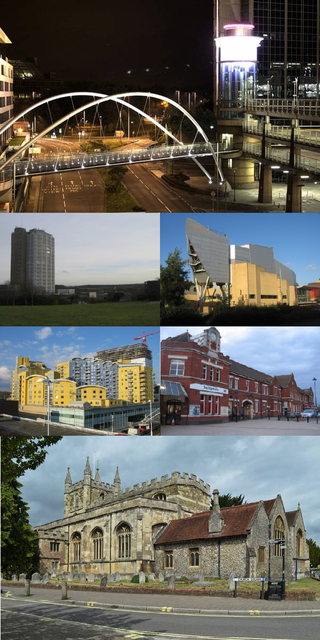
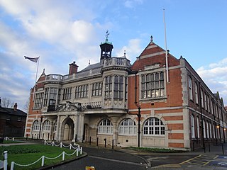
Basingstoke is a town in Hampshire, situated in south-central England across a valley at the source of the River Loddon on the western edge of the North Downs. It is the largest settlement in Hampshire without city status. It is located 30 miles (48 km) north-east of Southampton, 48 miles (77 km) south-west of London, 27 miles (43 km) west of Guildford, 22 miles (35 km) south of Reading and 20 miles (32 km) north-east of the county town and former capital Winchester. According to the 2016 population estimate, the town had a population of 113,776. It is part of the borough of Basingstoke and Deane and part of the parliamentary constituency of Basingstoke.

Thetford is a market town and civil parish in the Breckland District of Norfolk, England. It is on the A11 road between Norwich and London, just east of Thetford Forest. The civil parish, covering an area of 29.55 km2 (11.41 sq mi), in 2011 had a population of 24,340.

Theale is a village and civil parish in West Berkshire, England. It is 5 miles (8 km) southwest of Reading and 10 miles (16 km) east of Thatcham. The compact parish is bounded to the south and south-east by the Kennet & Avon Canal, to the north by a golf course, to the east by the M4 motorway and to the west by the A340 road.

Hursley is a village and civil parish in Hampshire, England with a population of around 900 in 2011. It is located roughly midway between Romsey and Winchester on the A3090. Besides the village the parish includes the hamlets of Standon and Pitt and the outlying settlement at Farley Chamberlayne.
Liss is a village and civil parish in the East Hampshire district of Hampshire, 3.3 miles (5.3 km) north-east of Petersfield, on the A3 road, on the West Sussex border. It covers 3,567 acres (14 km2) of semi-rural countryside in the South Downs National Park. Liss railway station is on the Portsmouth Direct line. The village comprises an old village at West Liss and a modern village round the 19th-century station. They are divided by the River Rother. Suburbs later spread towards Liss Forest.

Stratfield Turgis is a small village and civil parish in the north-east of the English county of Hampshire.

Four Marks is a village and civil parish in the East Hampshire district of Hampshire, England. It is 4.4 miles (7.1 km) southwest of Alton, on the A31 road. It is situated on the borders of the South Downs National Park on the Pilgrims' Way that leads from Winchester to Canterbury. It contains within it the medieval hamlets of Kitwood, Hawthorn and Lymington, although now the whole parish is relatively closely settled.

Bramham is a village in the civil parish of Bramham cum Oglethorpe in the City of Leeds metropolitan borough, West Yorkshire, England.

Kingsnorth is a village and civil parish in the Borough of Ashford in Kent, England. The civil parish adjoins the town of Ashford.
Dogmersfield is a small village lying between the towns of Fleet and Hartley Wintney in Hampshire, England. The M3 motorway and railway stations at Fleet and Winchfield provide routes to London.

Houghton is a small village and civil parish in the Test Valley district of Hampshire, England. The village is situated alongside the River Test. Its nearest town is Stockbridge, which lies approximately 1.8 miles (3 km) to the north-east. The village is a dispersed linear settlement, mostly strung out along the single road through the village, which broadly follows the course of the River Test north-south. Houghton is dominated by substantial agricultural/sporting estates at each end, the Houghton Lodge estate to the north and the Bossington estate to the south. Each owns a number of properties in the village.

Chineham is a civil parish on the outskirts of Basingstoke, Hampshire, England. It is situated about 3 miles (5 km) northeast of central Basingstoke, just north of the A33 road between Basingstoke and Reading.

The Salisbury and Southampton Canal was intended to be a 13-mile long canal in Hampshire and Wiltshire, southern England. Its proposed route ran from Redbridge, now a western suburb of Southampton at the head of Southampton Water, to Salisbury, and connecting with the Andover Canal at a junction near Mottisfont. Another section, through Southampton, was to connect via a tunnel to the River Itchen. Part of the canal was built and was in use by 1803, but it closed amid financial failure in 1806.

The Chichester to Silchester Way is a Roman Road between Chichester in South-East England, which as Noviomagus was capital of the Regni, and Silchester or Calleva Atrebatum, capital of the Atrebates. The road had been entirely lost and forgotten, leaving no Saxon place names as clues to its existence, until its chance discovery through aerial photography in 1949. Only 6 kilometres (3.7 mi) of the 62 kilometres (39 mi) long road remain in use.

Caesar's Camp is an Iron Age hill fort straddling the border of the counties of Surrey and Hampshire in southern England. The fort straddles the borough of Waverley in Surrey and the borough of Rushmoor and the district of Hart, both in Hampshire. Caesar's Camp is a Scheduled Ancient Monument with a list entry identification number of 1007895. It lies approximately 3 kilometres (1.9 mi) north of the town of Farnham, and a similar distance west of Aldershot. The hillfort lies entirely within the Bourley and Long Valley Site of Special Scientific Interest. Caesar's Camp is a multivallate hillfort, a fort with multiple defensive rings, occupying an irregular promontory, with an entrance on the south side. The site has been much disturbed by military activity, especially at the southeast corner. The remains of the hillfort are considered to be of national importance.

The River Hart is a tributary of the River Whitewater in north Hampshire, England. It rises at Ashley Head spring in Crondall and flows north to meet the Whitewater at Bramshill.

Daneshill Park Woods is a 4.4-hectare (11-acre) Local Nature Reserve in Basingstoke in Hampshire. It is owned and managed by Basingstoke and Deane Borough Council.

Fleet Brook is a small river in northern Hampshire, England and tributary of the River Hart.
References
- ↑ http://www.hants.gov.uk/hampshiretreasures/vol02/page012.html Archived 1 October 2007 at the Wayback Machine | accessdate = 2007-05-23