
Lyell Meadow is a meadow, in the region of Tuolumne Meadows, in Yosemite National Park.
Lyell Meadow is a meadow, in the region of Tuolumne Meadows, in Yosemite National Park.
Lyell Meadow divides into Lower-Upper Lyell Canyon Meadow, Upper Lyell Meadow, and Lower Lyell Meadow. Lower-Upper Lyell Meadow, is smaller than Upper Lyell Meadow, but is a large meadow encompassing 20.1 acres (8.1 ha). [1]

The John Muir Trail (JMT) is a long-distance trail in the Sierra Nevada mountain range of California, passing through Yosemite, Kings Canyon and Sequoia National Parks. From the northern terminus at Happy Isles in Yosemite Valley and the southern terminus located on the summit of Mount Whitney, the trail's length is 213.7 miles (343.9 km), with a total elevation gain of approximately 47,000 feet (14,000 m). For almost all of its length, the trail is in the High Sierra backcountry and wilderness areas. For about 160 miles (260 km), the trail follows the same footpath as the longer Pacific Crest Trail. It is named after John Muir, a naturalist.

Tuolumne Meadows is a gentle, dome-studded, sub-alpine meadow area along the Tuolumne River in the eastern section of Yosemite National Park in the United States. Its approximate location is 37°52.5′N119°21′W. Its approximate elevation is 8,619 feet (2,627 m). The term Tuolumne Meadows is also often used to describe a large portion of the Yosemite high country around the meadows, especially in context of rock climbing.

Hetch Hetchy is a valley, a reservoir, and a water system in California in the United States. The glacial Hetch Hetchy Valley lies in the northwestern part of Yosemite National Park and is drained by the Tuolumne River. For thousands of years before the arrival of settlers from the United States in the 1850s, the valley was inhabited by Native Americans who practiced subsistence hunting-gathering. During the late 19th century, the valley was renowned for its natural beauty – often compared to that of Yosemite Valley – but also targeted for the development of water supply for irrigation and municipal interests. The controversy over damming Hetch Hetchy became mired in the political issues of the day. The law authorizing the dam passed Congress on December 7, 1913.

The Dana Meadows can be found at the eastern entrance to Yosemite National Park, at the foot of Mount Dana, not far from Tuolumne Meadows and the Tioga Pass entrance station.

The Tuolumne River flows for 149 miles (240 km) through Central California, from the high Sierra Nevada to join the San Joaquin River in the Central Valley. Originating at over 8,000 feet (2,400 m) above sea level in Yosemite National Park, the Tuolumne drains a rugged watershed of 1,958 square miles (5,070 km2), carving a series of canyons through the western slope of the Sierra. While the upper Tuolumne is a fast-flowing mountain stream, the lower river crosses a broad, fertile and extensively cultivated alluvial plain. Like most other central California rivers, the Tuolumne is dammed multiple times for irrigation and the generation of hydroelectricity.

Mount Lyell is the highest point in Yosemite National Park, at 13,114 feet (3,997 m). It is located at the southeast end of the Cathedral Range, 1.2 miles (1.9 km) northwest of Rodgers Peak. The peak as well as nearby Lyell Canyon is named after Charles Lyell, a well-known 19th century geologist. The peak had one of the last remaining glaciers in Yosemite, Lyell Glacier. The Lyell Glacier is currently considered to be a permanent ice field, not a living glacier. Mount Lyell divides the Tuolumne River watershed to the north, the Merced to the west, and the Rush Creek drainage in the Mono Lake Basin to the southeast.
The Tuolumne Band of Me-Wuk Indians is a federally recognized tribe of Miwok people in Tuolumne County, California. The Tuolumne Band are central Sierra Miwok people. Annually, in September, the tribe holds an acorn festival and intertribal gathering.
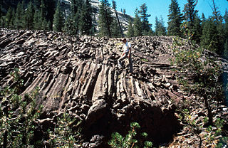
Little Devils Postpile is a columnar basalt rock formation in the Sierra Nevada, located within Yosemite National Park and eastern Tuolumne County, California.

Cherry Creek is a large, swift-flowing stream in the Sierra Nevada mountain range, and is the largest tributary of the Tuolumne River. The creek is 40 miles (64 km) long measured to its farthest headwaters; the main stem itself is 26 miles (42 km) long, draining a watershed of 234 square miles (610 km2) in the Stanislaus National Forest. Part of the drainage also extends into the northwest corner of Yosemite National Park.
Buck Meadows is a census-designated place in Mariposa County, California, United States. It is located 2 miles (3 km) east-northeast of Smith Peak, at an elevation of 3,015 feet (919 m). The population was 21 at the 2020 census.
Crane Flat Campground, elevation 6,200 feet (1,900 m), is located in Yosemite National Park, 17 miles (27 km) northwest of Yosemite Valley. Of all campgrounds outside of Yosemite Valley, Crane Flat is the closest to the Valley in terms of mileage and travel time. The campground is directly off the road. Each campsite contains a fire ring, picnic table, and food locker, and is near a bathroom with potable water and flushing toilets.
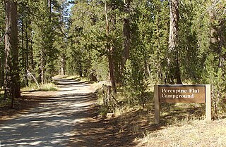
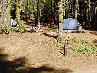
Porcupine Flat Campground, located in northern area of Yosemite National Park along Tioga Road, is a first-come first-served campground outside of Yosemite Valley. This campground is very remote, very quiet, and very unpopulated relative to other campgrounds in Yosemite. The campground is directly off the road and thus does not require a rough drive to the campground like other Yosemite campgrounds outside of the Valley. Porcupine Flat is directly along a branch of Snow Creek and therefore many of the sites inside the campground are directly alongside a running creek. Those looking to stay away from crowds/noise should consider this campground. The sites are very green and shaded by the trees in the area. Deer are often seen grazing in the campground.
White Wolf is a campground and concession area outside of Yosemite Valley in the northern area of Yosemite National Park along Tioga Road. The campground is directly off the road and thus does not require a rough drive to the campground such as other Yosemite campgrounds outside of the valley. White Wolf Campground contains 74 campsites and has the look and feel of Bridalveil Creek Campground. The campground is not near a creek and is quite rocky and sunny. The area also includes a cluster of wood-and-canvas cabins and a small restaurant and general store.

Little Yosemite Valley is a smaller glacial valley upstream in the Merced River drainage from the Yosemite Valley in Yosemite National Park. The Merced River meanders through the 3.5 mi (5.6 km) long flat valley, draining out over Nevada Fall and Vernal Fall before emptying into the main Yosemite Valley. It can be reached by a day hike from the main valley, and is the most popular area in the Yosemite Wilderness. The Valley provides access to nearby destinations such as the back side of Half Dome, Clouds Rest and the High Sierra Camp at Merced Lake.

Yosemite National Park is located in the central Sierra Nevada of California. Three wilderness areas are adjacent to Yosemite: the Ansel Adams Wilderness to the southeast, the Hoover Wilderness to the northeast, and the Emigrant Wilderness to the north.

Lyell Canyon is a sub-alpine meadow in Yosemite National Park south of Tuolumne Meadows. For 13 kilometers most of the canyon has an approximate elevation of 2 700 meters, and then rapidly climbs to 3 370 meters to Donohue Pass, below Donohue Peak – which marks the eastern boundary of Yosemite. The valley at the base is relatively flat and wide, following the Lyell Fork of the Tuolumne River through an open meadow and wooded areas. The Lyell Fork eventually meets with Tuolumne River.
Mountain Meadow or Mountain Meadows, is an area in present-day Washington County, Utah. It was a place of rest and grazing used by pack trains and drovers, on the Old Spanish Trail and later Mormons, Forty-niners, mail riders, migrants and teamsters on the Mormon Road on their way overland between Utah and California.
Hiking, rock climbing, and mountain climbing around Tuolumne Meadows in Yosemite National Park has many options.

Kuna Crest is a mountain range near Tuolumne Meadows, in Yosemite National Park, California.

Donohue Peak is a mountain, in the northern part of Yosemite National Park. Donohue Peak is along Yosemite National Park's eastern border, in the area of Tuolumne Meadows.
Coordinates: 37°47′31″N119°15′40″W / 37.792°N 119.261°W
| | This Yosemite-related article is a stub. You can help Wikipedia by expanding it. |