Gallery
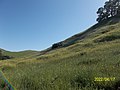
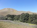
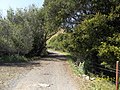 Lynch Road
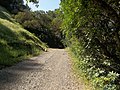


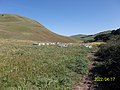
 Beehives

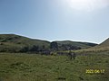
 A hare on Lynch Road
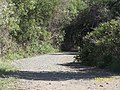
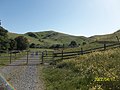 A fence across Lynch Road
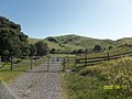
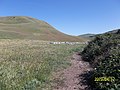
Lynch Canyon Open Space Park is a park in Solano County, California. [1] Its trails are part of the Bay Area Ridge Trail. [2]
It is named for the Matthew Lynch family. [3] Lynch Canyon Open Space Park has been operated by the Solano County Parks and Recreation Division and the Solano Land Trust since 2007. [3]


Claremont Canyon Regional Preserve is a small regional park mainly located in the city of Oakland, California, and administered by the East Bay Regional Park District. The park is named for the canyon in which it is situated, Claremont Canyon, out of which Claremont Creek flows on its way to its confluence with Temescal Creek. Originally, the canyon was named Harwood's Canyon, and then later as Telegraph Canyon. The name was changed to Claremont by a developer of the nearby Claremont district.

Buckeye is a farming and ranching unincorporated community in north central Larimer County, Colorado, United States. Bounded on the west by the 16,500-acre (67 km2) Roberts Ranch, the area includes Red Mountain Open Space to the north, Rawhide flats to the east, and extends south to Owl Canyon.
Elysian Park is a neighborhood in Central Los Angeles, California. It is a predominantly low-income community, and has a population of more than 2,600 people. A city park, Elysian Park, and Dodger Stadium are within the neighborhood, as are an all-boys Catholic high school and an elementary school.

Runyon Canyon Park is a 160-acre (65 ha) park in Los Angeles, California, at the eastern end of the Santa Monica Mountains, managed by the Los Angeles Department of Recreation and Parks. The southern entrance to the park is located at the north end of Fuller Avenue in Hollywood. The northern entrance is off the 7300 block of Mulholland Drive. The Runyon Canyon Road, a fire road that is closed to public motor vehicle access, runs roughly through the center of the park between the northern and southern entrances along Runyon Canyon itself, and there are numerous smaller hiking trails throughout the park. The highest point in the park at an elevation of 1,320 ft is known as Indian Rock. Because of its proximity to residential areas of Hollywood and the Hollywood Hills, celebrity sightings are common. The park is also noted for having a fairly liberal dog policy, with dogs allowed off-leash in 90 of the park's 160 acres (0.65 km2).

Sanborn County Park is a 3,453 acres (13.97 km2) public park situated in the Santa Cruz Mountains owned by the county of Santa Clara, California, adjacent to Castle Rock State Park and the Los Altos Rod and Gun Club Range and Santa Clara County Peace Officers Association gun range. The park is managed by the Santa Clara County Parks and Recreation Department. The park is heavily forested and offers hiking and other generally low intensity outdoor uses. The park lies between the town of Saratoga and the ridgetop road, Skyline Boulevard. In the summer months, Sanborn County Park hosts the only outdoor Shakespearean company in Silicon Valley.
Weldon Canyon is the name of two canyons in California.
Bishop Ranch Regional Preserve (BRRP), also known as Bishop Ranch Regional Open Space Preserve is a 444-acre (1.80 km2) regional park on a ridge top at the edge of San Ramon, California. It is near a residential area, west of San Ramon Valley Road and south of Bollinger Canyon Road. Trails are steep and there are no facilities other than a trailhead. It is part of the East Bay Regional Park District (EBRPD).

Carquinez Strait Regional Shoreline is a regional park, part of the East Bay Regional Park District system, located in northwestern Contra Costa County, California.

Radke Martinez Regional Shoreline (RMRS) is a regional park on the shoreline of Carquinez Strait in Martinez, located in northern Contra Costa County, California. Formerly known as the Martinez Regional Shoreline, it was renamed on December 6, 2016, in honor of the late Ted Radke and his late wife Kathy Radke.

Eaton Canyon is a major canyon beginning at the Eaton Saddle near Mount Markham and San Gabriel Peak in the San Gabriel Mountains in the Angeles National Forest, United States. Its drainage flows into the Rio Hondo river and then into the Los Angeles River. It is named after Judge Benjamin S. Eaton, who lived in the Fair Oaks Ranch House in 1865 not far from Eaton Creek.
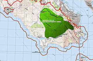
Marincello was a failed development project in Marin County, California that would have put a planned community atop the Marin Headlands, overlooking the Golden Gate. Its upheaval set the precedent for Marin County's rigid anti-development stance and push for open space.
Bell Canyon Park is a large open-space regional park located in the Simi Hills at the western end of the San Fernando Valley in West Hills, Los Angeles and Bell Canyon, California. Bell Creek, a primary tributary to the Los Angeles River, flows through the park with riparian zone vegetation along its natural banks. The geographic landmark Escorpión Peak is high above it to the south in adjacent El Escorpión Park.

Sierra Azul Open Space Preserve is managed by the Midpeninsula Regional Open Space District in Santa Clara County, California. It is approximately 17,000 acres (6,900 ha) in area. The preserve is named for the Sierra Azul or "Blue Mountains", the name the colonizing Spanish used for the half of the Santa Cruz Mountains south of today's California Highway 17.

The Phleger Estate is a park in San Mateo County, California. The park is located outside the town of Woodside and adjacent to Huddart County Park. The park was acquired in 1991 by the Peninsula Open Space Trust (POST) for $25 million and is now part of the Golden Gate National Recreation Area (GGNRA).

Monte Bello Open Space Preserve is a 3,133-acre (12.68 km2) open space preserve, located near Palo Alto in the Santa Cruz Mountains, in San Mateo and Santa Clara Counties, California, United States. The preserve encompasses the upper Stevens Creek watershed in the valley between Monte Bello Ridge and Skyline Ridge. "Monte Bello" means "beautiful mountain" in Italian, and refers to Black Mountain which is the highest part of Montebello Ridge. The straight valley of upper Stevens Creek is also the rift valley of the San Andreas Fault.
The Trail of the Ancients is a collection of National Scenic Byways located in the U.S. Four Corners states of Utah, Colorado, New Mexico, and Arizona. These byways comprise:

Alamitos Creek or Los Alamitos Creek is a 7.7-mile-long (12.4 km) creek in San Jose, California, which becomes the Guadalupe River when it exits Lake Almaden and joins Guadalupe Creek. Los Alamitos Creek is located in Almaden Valley and originates from the Los Capitancillos Ridge in the Santa Cruz Mountains, near New Almaden. This creek flows through the Valley's Guadalupe Watershed, which is owned by the Santa Clara Valley Water District. The creek flows in a generally northwesterly direction after rounding the Los Capitancillos Ridge and the town of New Almaden, in the southwest corner, before ambling along the Santa Teresa Hills on northeast side of the Almaden Valley. Its environment has some relatively undisturbed areas and considerable lengths of suburban residential character. Originally called Arroyo de los Alamitos, the creek's name is derived from "little poplar", "alamo" being the Spanish word for "poplar" or "cottonwood".

Long Ridge Open Space Preserve is a 2,035 acre open space preserve along Long Ridge in the Santa Cruz Mountains.
Rockville Hills Regional Park is a 633-acre regional park in the city of Fairfield, Solano County, California, United States. The park is known for its volcanic rocks, thin topsoil, grasses, and blue oak trees. There are also oak woodlands, grassland savannas, chaparral and some aquatic habitats.
The 1,534 acres (621 ha) Mill Creek Redwood Preserve is located in Big Sur, California, 6.8 miles (10.9 km) from Highway 1 on Palo Colorado Road. The park is owned by the Monterey Peninsula Regional Park District. To alleviate resistance by residents of Palo Colorado Canyon who were concerned about the impact of traffic on the narrow, one-lane road, access was limited to six visitors per day who must obtain a permit in advance from the district. The preserve was pieced together from several large properties between 1988 and 2000 at a cost of $2 million. When open, it is only accessible via trail from the road. The preserve was severely damaged by the Soberanes fire and is closed indefinitely.
Coordinates: 38°11′28″N122°11′49″W / 38.191°N 122.197°W
| | This Solano County, California-related article is a stub. You can help Wikipedia by expanding it. |