
A cave or cavern is a natural void under the Earth's surface. Caves often form by the weathering of rock and often extend deep underground. Exogene caves are smaller openings that extend a relatively short distance underground. Caves which extend further underground than the opening is wide are called endogene caves.

Wookey Hole Caves are a series of limestone caverns, a show cave and tourist attraction in the village of Wookey Hole on the southern edge of the Mendip Hills near Wells in Somerset, England. The River Axe flows through the cave. It is a Site of Special Scientific Interest (SSSI) for both biological and geological reasons. Wookey Hole cave is a "solutional cave", one that is formed by a process of weathering in which the natural acid in groundwater dissolves the rocks. Some water originates as rain that flows into streams on impervious rocks on the plateau before sinking at the limestone boundary into cave systems such as Swildon's Hole, Eastwater Cavern and St Cuthbert's Swallet; the rest is rain that percolates directly through the limestone. The temperature in the caves is a constant 11 °C (52 °F).

Mammoth Cave National Park is a national park of the United States in south-central Kentucky. It encompasses portions of Mammoth Cave, the longest known cave system in the world. The park's 52,830 acres (21,380 ha) are located primarily in Edmonson County, with small areas extending eastward into Hart and Barren counties. The Green River runs through the park, with a tributary called the Nolin River feeding into the Green just inside the park.

Blanchard Springs Caverns is a cave system located in the Ozark–St. Francis National Forest in Stone County in northern Arkansas, USA, 2 miles (3.2 km) off Highway 14 a short distance north of Mountain View. It is the only tourist cave owned by the United States Forest Service and the only one owned by the federal government outside the National Park System. Blanchard Springs Caverns is a three-level cave system, all of which can be viewed on guided tours.

A geode is a geological secondary formation within sedimentary and volcanic rocks. Geodes are hollow, vaguely spherical rocks, in which masses of mineral matter are secluded. The crystals are formed by the filling of vesicles in volcanic and subvolcanic rocks by minerals deposited from hydrothermal fluids; or by the dissolution of syn-genetic concretions and partial filling by the same or other minerals precipitated from water, groundwater, or hydrothermal fluids.

The Cango Caves are located in Precambrian limestones at the foothills of the Swartberg range near the town of Oudtshoorn, in the Western Cape Province of South Africa. The principal cave is one of the country's finest, best known, and most popular tourist caves and attracts many visitors from overseas. Although the extensive system of tunnels and chambers go on for over 4 km, only about a quarter of this is open to visitors, who may proceed into the cave only in groups supervised by a guide.

The Marble Arch Caves are a series of natural limestone caves located near the village of Florencecourt in County Fermanagh, Northern Ireland. The caves are named after the nearby Marble Arch, a natural limestone arch at the upstream end of Cladagh Glen under which the Cladagh River flows. The caves are formed from three rivers draining off the northern slopes of Cuilcagh mountain, which combine underground to form the Cladagh. On the surface, the river emerges from the largest karst resurgence in Ireland, and one of the largest in the United Kingdom. At 11.5 kilometres (7.1 mi) the Marble Arch Caves form the longest known cave system in Northern Ireland, and the karst is considered to be among the finest in the British Isles.

The petrous part of the temporal bone is pyramid-shaped and is wedged in at the base of the skull between the sphenoid and occipital bones. Directed medially, forward, and a little upward, it presents a base, an apex, three surfaces, and three angles, and houses in its interior the components of the inner ear. The petrous portion is among the most basal elements of the skull and forms part of the endocranium. Petrous comes from the Latin word petrosus, meaning "stone-like, hard". It is one of the densest bones in the body. In other mammals, it is a separate bone, the petrosal bone.
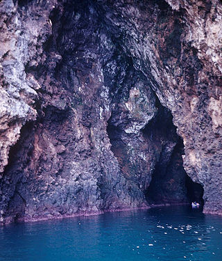
A sea cave, is also known as a littoral cave, a type of cave formed primarily by the wave action of the sea. The primary process involved is erosion. Sea caves are found throughout the world, actively forming along present coastlines and as relict sea caves on former coastlines. Some of the largest wave-cut caves in the world are found on the coast of Norway, but are now 100 feet or more above present sea level. These would still be classified as littoral caves. By contrast, in places like Thailand's Phang Nga Bay, solutionally formed caves in limestone have been flooded by the rising sea and are now subject to littoral erosion, representing a new phase of their enlargement.

The Belum Caves, located in Nandyala district of Andhra Pradesh's Rayalaseema region, is the second largest cave system on the Indian subcontinent, known for its speleothems, such as stalactite and stalagmite formations. The Belum Caves have long passages, galleries, spacious caverns with fresh water and siphons. This cave system was formed over the course of tens of thousands of years by the constant flow of underground water from the now-disappeared river Chitravathi. The cave system reaches its deepest point at the point known as Pataalaganga. Belum Caves have a length of 3,229 m (10,593.8 ft), making them the second largest caves on the Indian Subcontinent after the Krem Liat Prah caves in Meghalaya. It is one of the centrally protected Monuments of National Importance.

Deer Cave, located near Miri, Sarawak, Malaysia, is a show cave attraction of Gunung Mulu National Park. It was surveyed in 1961 by G. E. Wilford of the British Borneo Geological Survey, who predicted that Mulu would yield many more caves in the future. The cave, which is also known as Gua Payau or Gua Rusa by the local Penan and Berawan people, is said to have received its name because of the deer that go there to lick salt-bearing rocks and shelter themselves.

The Nyero rock paintings are located in eastern Uganda in Kumi District, 8 km (5.0 mi) west of Kumi town, about 250 km (155.3 mi) from the capital city Kampala. The Nyero rock paintings are among the most important rock art in Uganda.
The Pettigarths Field Cairns is a Neolithic site in the parish of Nesting, northeastern Whalsay, in the Shetland islands of Scotland. It is located approximately 140 metres (460 ft) to the northwest of Benie Hoose. The site contains upright stones as well as masonry. The south cairn is roughly 6 metres (20 ft) square, with an eastern entrance passage and circular chamber about 2 metres across. 4 metres (13 ft) to the north is a round cairn, 4.5 metres (15 ft) in diameter, with a rectangular cist. The two cairns are located on a rise, about 140 metres (460 ft) northwest of Benie Hoose.

Death's Head Hole is a cave on Leck Fell, in Lancashire, England. Its entrance is a 64-metre (210 ft) deep shaft. It leads into Lost Johns' Cave and is part of the Three Counties System, an 87-kilometre (54 mi) cave system which spans the borders of Cumbria, Lancashire, and North Yorkshire.

Atlantida is a karst cave in Ukraine, most famous for its unusual geology, rare formations, and pristine condition. It is located at the bank of the river Zbruch in Kamianets-Podilskyi Raion of Khmelnytskyi Oblast, close to Zavallya village. The cave is 2525 m long and 18 m deep, with 4440 m² area. Subordinated to the Tourism and Excursions Council of Khmelnytskyi Oblast, the cave is a part of the Podilski Tovtry National Nature Park.

The Radochów Cave is a karst cave in lenticular marble. It is situated in the valley of the Jaskiniec Stream, at the foot of Bzowiec in the Golden Mountains of, near the village of Radochów, Poland.

Volodymyr Dobrianskyi is a Ukrainian scientist, archaeologist, historian, speleologist, and researcher of antiquities, fortifications and toponymy. He became a member of the Ukrainian Society for the Protection of Historical and Cultural Monuments in 1981, the Shevchenko Scientific Society in 2000, and the National Union of Journalists of Ukraine from 2016 to 2020. He also co-founded the NGO "Alternative-Chortkiv". He also participated in liquidating the Chernobyl accident of the second category.

Shmankivtsi Castle is a lost defensive structure in the village of Shmankivtsi, Zavodske settlement hromada, Chortkiv Raion, Ternopil Oblast, Ukraine.

The Grotto of Saint Onuphrius is a unique geological monument of nature, archeology, and history of the left bank of Middle Podnistrovia. It is in Ulashkivtsi in the Nahirianka rural hromada, Chortkiv Raion, Ternopil Oblast.
Kyrnychky is a cave located in the Ukrainian village of Horodok, Zalishchyky Hromada, Chortkiv Raion, Ternopil Oblast. It is located 700-800 meters northeast of the village. It belongs to the Nyzhnoseretska karst area.
